 EMODnet product catalogue
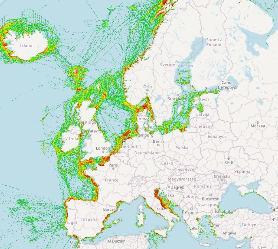
EMODnet Human Activities, EMSA Route Density Map
The Route Density Map at 1 km resolution was created by EMSA in 2019 and made available on EMODnet Human Activities, an initiative funded by the EU Commission.
Simple
- Date (Publication)
- 2019-12-19
- Date (Revision)
- 2025-06-04
- Date (Creation)
- 2019-12-19
- Citation identifier
- EMODnet_HA_EMSA_Route_Density_Map_20191111
- Point of contact
-
Organisation name Individual name Electronic mail address Role EMSA
Author
-
INSPIRE feature concept dictionary (Version: Linked Data 1.0)
-
-
Marine Layer
-
Marine Waterway
-
Transport Area
-
-
GEMET - INSPIRE themes, version 1.0
-
-
Geographical grid systems
-
- Use limitation
-
The Route Density Maps are produced and provided to EMODnet by the European Maritime Safety Agency (EMSA) solely for the purposes of EMODnet. EMODnet shall ensure the storage of the received the data and prepare and distribute maps via the EMODnet portal using its own data conversion and presentation tools and methodologies. The data made available through EMODnet portal and the maps produced by EMODnet from the data shall have reference to EMSA as the source of data. Users shall make reference to EMSA as the source of data when using them, promoting them or generating related publications, whatever the purpose. EMODnet Human Activities accepts no responsibility or liability whatsoever for the re-use of content accessible on its website.
- Access constraints
- Other restrictions
- Other constraints
-
no limitation
- Spatial representation type
- raster
- Distance
- 1000 sq mt
- Language
- English
- Topic category
-
- Oceans
))
- Begin date
- 2019-01-01
- End date
- 2025-05-31
- Reference system identifier
- EPSG / EPSG:3035
- Reference system identifier
- ISO 19108 calendar
- Distribution format
-
Name Version GeoTIFF
- Transfer size
- 0
- OnLine resource
- Hierarchy level
- Dataset
Conformance result
- Title
-
COMMISSION REGULATION (EC) No 1205/2008 of 3 December 2008 implementing Directive 2007/2/EC of the European Parliament and of the Council as regards metadata
- Date (Publication)
- 2008-12-04
- Explanation
-
See the referenced specification
- Pass
- Yes
Conformance result
- Title
-
Corrigendum to INSPIRE Metadata Regulation published in the Official Journal of the European Union, L 328, page 83
- Date (Publication)
- 2009-12-15
- Explanation
-
See the referenced specification
Conformance result
- Title
-
Commission Regulation (EU) No 1089/2010 of 23 November 2010 implementing Directive 2007/2/EC of the European Parliament and of the Council as regards interoperability of spatial data sets and services
- Date (Publication)
- 2010-12-08
- Explanation
-
See the referenced specification
- Pass
- Yes
- Statement
-
On the bases of a Service Level Agreement (SLA) signed between EMSA and the European Commission - DG MARE for the provision and use of vessel traffic density mapping data, the route density maps data files were produced and provided to EMODnet by the European Maritime Safety Agency (EMSA). The method selected by EMSA and agreed by the Member States is the ship routes restoring method. This method rebuilds the track of each distinct ship from the recorded positions and counts how many routes are crossing each cell of a grid during a given period of time. This method can be implemented in all regions (coastal and open sea), using all the available ships position data and allows connecting ship routes even within areas with a low coverage. The grids used as reference to build the route density maps are constructed to cover all the target areas and have a definition of 1x1 km. The grids are based on the EMODnet constructed grids. In order to build a density map, the first step is to collect ship positions data from EMSA’s ship position database. Terrestrial AIS (T-AIS) and satellite AIS (S-AIS) data are collected by using an SQL query (filtering). Each ship position is collected with the indication of the ship’s type. The position data is collected and aggregated per period of time and target area (e.g. North Sea-Atlantic, Atlantic, Baltic Sea, Mediterranean Sea, Black Sea and All Europe). Positions are checked to remove improbable situations, e.g. erroneous positions or duplicated positions. Position data with a high frequency acquisition (e.g. T-AIS data) is down-sampled (e.g. one position per 6 minutes). S-AIS data normally is not down-sampled. The down sampling rate is configurable. The routes are recreated by connecting the position reports into polylines using the acquisition time stamp to order the points in a chronological order (per MMSI and a period). The polylines are then tagged per AIS ship types ranges: Passenger (includes AIS ship type codes 60 to 69); Cargo (includes AIS ship type codes 70 to 79); Tanker (includes AIS ship type codes 80 to 89); Fishing (includes AIS ship type code 30); All Other (includes all other ship types), and All Traffic (includes all ships monitored). The polyline segments which are obviously improbable are removed, such as: segments joining two consecutive positions of the same vessel (MMSI) too distant in time from each other; too long segments joining two consecutive positions of the same vessel (e.g. more than 100 NM); too short segments joining two consecutive positions of the same vessel (e.g. less than 10m.); segments overlapping land area (either by checking if the polyline goes beyond existing grid cells or it crosses a land polygon), etc. The filtering settings are configurable. The traffic density map is created by counting the number of routes (polylines) crossing each grid cell and applying a colour code corresponding to the number of crossings. The system counts the number of polylines crossing boundary of each cell. The output of this process is a grid data file containing the number of vessel route crossings per cell. The data files are created for all combinations of the predefined criteria (i.e. area, ship type range and time period). The traffic density (the number of polylines crossing each cell) is presented by using a colour code per the range of values. A corresponding colour code is given to each cell. The output of this process is a georeferenced image file showing a density map with a predefined code by cell. The files are created for all combinations of the predefined criteria (i.e. area, ship type range and time period). Once a set of basic maps (grid data files) are created, they can be combined (using the sum function) to create new maps. This allows to avoid re-treatment of the data. The final route density maps are produced by aggregating (stacking and summing) the intermediate files generated according to the configured time criteria (i.e. monthly, seasonal and annual maps) and ship type ranges (i.e. Cargo, Fishing, Passenger, Tanker, All Other and All traffic) and finally clipping according to the preconfigured geographic area (e.g. All Europe). For each individual map, the following files are produced: a georeferenced image showing a density map with a predefined colour code by cell (e.g. a GeoTiff file); a grid data file containing the number of vessels routes crossings per cell (e.g. GeoTiff 16 bit signed)(Value - 9999 is assigned for cells without data); and, a metadata file, providing information about the route density map. The methodology is available at the EMSA website.
Metadata
- File identifier
- 74eef9c6-13fe-4630-b935-f26871c8b661 XML
- Metadata language
- English
- Character set
- UTF8
- Hierarchy level
- Dataset
- Date stamp
- 2025-06-04T14:41:39.991552Z
- Metadata standard name
-
ISO19115
- Metadata standard version
-
2003/Cor.1:2006
- Metadata author
-
Organisation name Individual name Electronic mail address Role EMSA
Point of contact
)))
