 EMODnet Product Catalogue
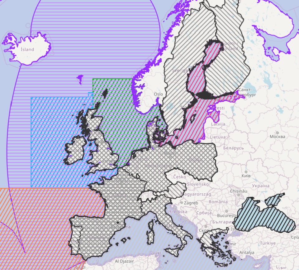
EMODnet Human Activities, Regional Advisory Councils
This shape lists the areas covered by the Regional Advisory Councils (RAC) as poligons as exposed in the Atlas of the Seas. The Black Sea, Aquaculture, Markets and Outermost Regions Advisory Conucils have been added. Aditional information regarding to legal fundation have been added to the original shape.
owner : {{md.getOwnername()}}
{{'mdStatusRecord' | translate}}: {{('mdStatus-' + md.mdStatus) | translate}}
- Identification
- Content
- ReferenceSystem
- Quality
- DomainConsistancy
- Constraints
- Distribution
- Meta-metadata
- ObjectCatalogue
| Date | 2014-05-18 |
|---|---|
| Date type | Creation: Date identifies when the resource was brought into existence |
| Unique resource identifier | Emodnet_Human_Activities_Others_Managements_WGS84 |
mdConstraintsSection
Resource constraints
|
|||||
Point of contact
| Organisation name | Fundación CETMAR |
|---|---|
| Electronic mail address | socioeconomia@cetmar.org |
| Role | Processor: Party wha has processed the data in a manner such that the resource has been modified |
Descriptive keywords
| GEMET - INSPIRE themes, version 1.0 | |
|---|---|
| Advisory Councils | Maritime boundaries |
| Language | English |
|---|---|
| Topic category code |
|
| Hierarchy level | Dataset: Information applies to the dataset |
|---|
Lineage
| Statement | Information about fundation and countries represented in each RAC has been added to information contained in the original source (Atlas of the Seas). Furthermore the original shapefile has been reprojeted into WGS84. Validation and quality assurance remain up to primary data sources, while harmonization is carried out by CETMAR. For further information on validation and quality assurance, it is suggested that primary data sources are contacted. |
|---|
Domain consistency
Conformance result
|
|||||||||||
mdLegalAndSecurityConstraintsSection
Resource constraints
|
|||||||||
| Distribution format | unknown (Version: unknown) | ||||||||||||||||||||||||||||||||||||||||||||||||||||||||||||||||||||||||||||||||||||||||||||||||||||||||||||||||||||||||||||||||||||||||||||||||||||||||||||||||||||||||||||||||||||||||||||||||||||||||||||||||||||||||||||||||||||||||||||||||||||||||||||||||||||
|---|---|---|---|---|---|---|---|---|---|---|---|---|---|---|---|---|---|---|---|---|---|---|---|---|---|---|---|---|---|---|---|---|---|---|---|---|---|---|---|---|---|---|---|---|---|---|---|---|---|---|---|---|---|---|---|---|---|---|---|---|---|---|---|---|---|---|---|---|---|---|---|---|---|---|---|---|---|---|---|---|---|---|---|---|---|---|---|---|---|---|---|---|---|---|---|---|---|---|---|---|---|---|---|---|---|---|---|---|---|---|---|---|---|---|---|---|---|---|---|---|---|---|---|---|---|---|---|---|---|---|---|---|---|---|---|---|---|---|---|---|---|---|---|---|---|---|---|---|---|---|---|---|---|---|---|---|---|---|---|---|---|---|---|---|---|---|---|---|---|---|---|---|---|---|---|---|---|---|---|---|---|---|---|---|---|---|---|---|---|---|---|---|---|---|---|---|---|---|---|---|---|---|---|---|---|---|---|---|---|---|---|---|---|---|---|---|---|---|---|---|---|---|---|---|---|---|---|---|---|---|---|---|---|---|---|---|---|---|---|---|---|---|---|---|---|---|---|---|---|---|---|---|---|---|---|---|---|---|---|---|---|
Transfer options
|
|||||||||||||||||||||||||||||||||||||||||||||||||||||||||||||||||||||||||||||||||||||||||||||||||||||||||||||||||||||||||||||||||||||||||||||||||||||||||||||||||||||||||||||||||||||||||||||||||||||||||||||||||||||||||||||||||||||||||||||||||||||||||||||||||||||
| File identifier | 7e539449-48b8-4e5f-87f3-e5e2ff4cfe1b | ||||||
|---|---|---|---|---|---|---|---|
| Metadata language | English | ||||||
| Character set | MD_CharacterSetCode_utf8: MD_CharacterSetCode_utf8 | ||||||
| Hierarchy level | Dataset: Information applies to the dataset | ||||||
| Date stamp | 2024-02-14T14:17:08.136702Z | ||||||
| Metadata standard name | ISO19115 | ||||||
| Metadata standard version | 2003/Cor.1:2006 | ||||||
Contact
|
|||||||
Overviews
extent
- geoDesc
- {{d}}
- geoBox
-
}})
- geoDescCode
- {{mdView.current.record.geoDescCode}}
tempExtent
- creationDate
- publicationDate
- revisionDate
- tempExtentBegin
Associated resources
Not available