 EMODnet product catalogue
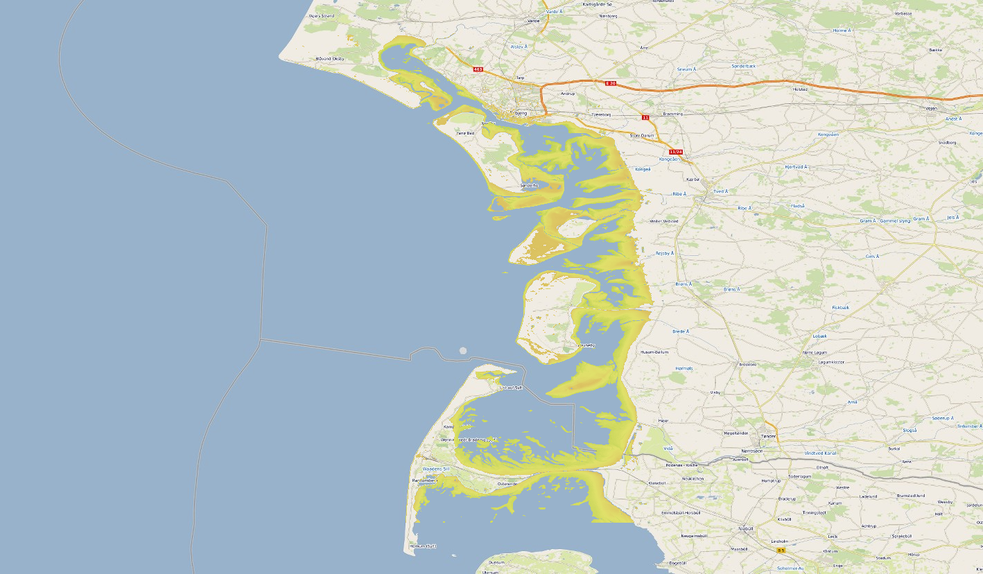
1528_IB_Danske_Vadden_2020
Satellite-derived intertidal bathymetry for the Danish Wadden on the West coast of Denmark
Simple
- Alternate title
-
KN172L08 SeaBeam 3012-P1 Bathymetry Grid
- Date (Creation)
- 2020-12-15T00:00:00
- Date (Revision)
- Invalid DateT00:00:00
- Citation identifier
- IB_Danske_Vadden_2020_64
- Point of contact
-
Organisation name Individual name Electronic mail address Role Deltares
Originator Deltares
Custodian
-
Project name
-
-
EMODNet Bathymetry
-
-
Parameter Discovery Vocabulary (P02)
-
-
Bathymetry and Elevation
-
-
GEMET - INSPIRE themes, version 1.0
-
-
Hydrography
-
- Access constraints
- Creative Commons Attribution 4.0 International
- Use constraints
- Other restrictions
- Other constraints
-
DO NOT USE FOR NAVIGATION
- Spatial representation type
- Grid
- Denominator
- 50000
- Distance
- 0.0002694945851899888 degree
- Language
- English
- Character set
- UTF8
- Topic category
-
- Oceans
- Begin date
- 2017-01-01T09:00:00
- End date
- 2019-01-01T09:00:00
))
- Description
-
Map projection parameters, values and units :
Axes units :
UPPER LEFT X=29.3054583250
UPPER LEFT Y=44.6262830219
LOWER RIGHT X=40.7816282263
LOWER RIGHT Y=41.2281769950
WEST LONGITUDE=29° 18' 19.6500" E
NORTH LATITUDE=44° 37' 34.6189" N
EAST LONGITUDE=40° 46' 53.8616" E
SOUTH LATITUDE=41° 13' 41.4372" N
PROJ_DESC=Geographic (Latitude/Longitude) / WGS84 / arc degrees
PROJ_DATUM=WGS84
PROJ_UNITS=arc degrees
EPSG_CODE=4326
COVERED AREA=353215 sq km
- Geographic identifier
- EPSG / WGS84 / Geographic coordinate system / 7.4
- Reference system identifier
- EPSG / WGS 84 (EPSG:4326) / 7.4
- Number of dimensions
- 3
- Dimension name
- Column
- Dimension size
- 2226
- Dimension name
- Row
- Dimension size
- 2969
- Dimension name
- Time
- Dimension size
- 1
- Resolution
- 10 day
- Cell geometry
- Point
- Transformation parameter availability
- No
- Checkpoint Availability
- No
- Point in Pixel
-
- Lower left
- Distribution format
-
Name Version NetCDF
4
- Distributor contact
-
Organisation name Individual name Electronic mail address Role Deltares
Distributor
- Transfer size
- 26
- OnLine resource
-
Protocol Linkage Name WWW:LINK
https://emodnet.ec.europa.eu/sites/emodnet.ec.europa.eu/files/public/20201219_emodnet_bathymetry_satellite_derived_coastline_report.pdf report
WWW:LINK
https://emodnet.ec.europa.eu/geoviewer/ EMDOnet viewer
WWW:DOWNLOAD
https://downloads.emodnet-bathymetry.eu/high_resolution/1528_IB_Danske_Vadden_2020_64.emo.zip WWW:LINK
https://tiles.emodnet-bathymetry.eu/ EMODnet Bathymetry WMTS service
- Hierarchy level
- Dataset
Vertical extent
- Minimum value
- 2
- Maximum value
- -2
Vertical CS
Vertical datum
- Statement
-
no information
- Hierarchy level
- Feature
- Dataset
-
accuracy
Gridded data positional accuracy
- Name of measure
-
horizontal accuracy
- Measure identification
- horizontal accuracy of coordinate
- Measure description
-
20 meters
- Evaluation method description
-
Rough estimate from comparison to other data
Quantitative result
- Value type
- horizontal accuracy
Quantitative attribute accuracy
- Name of measure
-
depth
- Measure identification
- depth accuracy
- Measure description
-
20 cm
- Evaluation method description
-
Rough estimate
Quantitative result
- Value
- not defined
Conformance result
- Title
-
Shoal bias
- Date
- Explanation
-
na
- Hierarchy level
- Software
- Description
-
MB-System
- Other
-
software
- Hierarchy level
- Property type
- Description
-
parameters of data processing
Attributes
- Statement
-
Water-occurrence from many satellite images combined with water height frequencies from the model.
- Description
-
Combination of optical satellite and a water-levels computed with a numerical model
- Hierarchy level
- Dataset
Absolute external positional accuracy
- Name of measure
-
emodnet-bathymetry.QI.Horizontal
- Value
- 2
Absolute external positional accuracy
- Name of measure
-
emodnet-bathymetry.QI.Vertical
- Value
- -1 - Multisources
Domain consistency
- Name of measure
-
emodnet-bathymetry.QI.Purpose
- Value
- 1 - Transit and/or opportunity
Metadata
- File identifier
- SDN_CPRD_1528_IB_Danske_Vadden_2020_64 XML
- Metadata language
- English
- Character set
- UTF8
- Hierarchy level name
-
Composite Product Record
- Date stamp
- 2025-03-07T15:17:16.428418Z
- Metadata standard name
-
ISO 19115:2003/19139 - EMODNET - BATHYMETRY
- Metadata standard version
-
1.0
- Metadata author
-
Organisation name Individual name Electronic mail address Role Deltares
Author
)))
