Mega_Dunes_Gulf_of_Cadiz
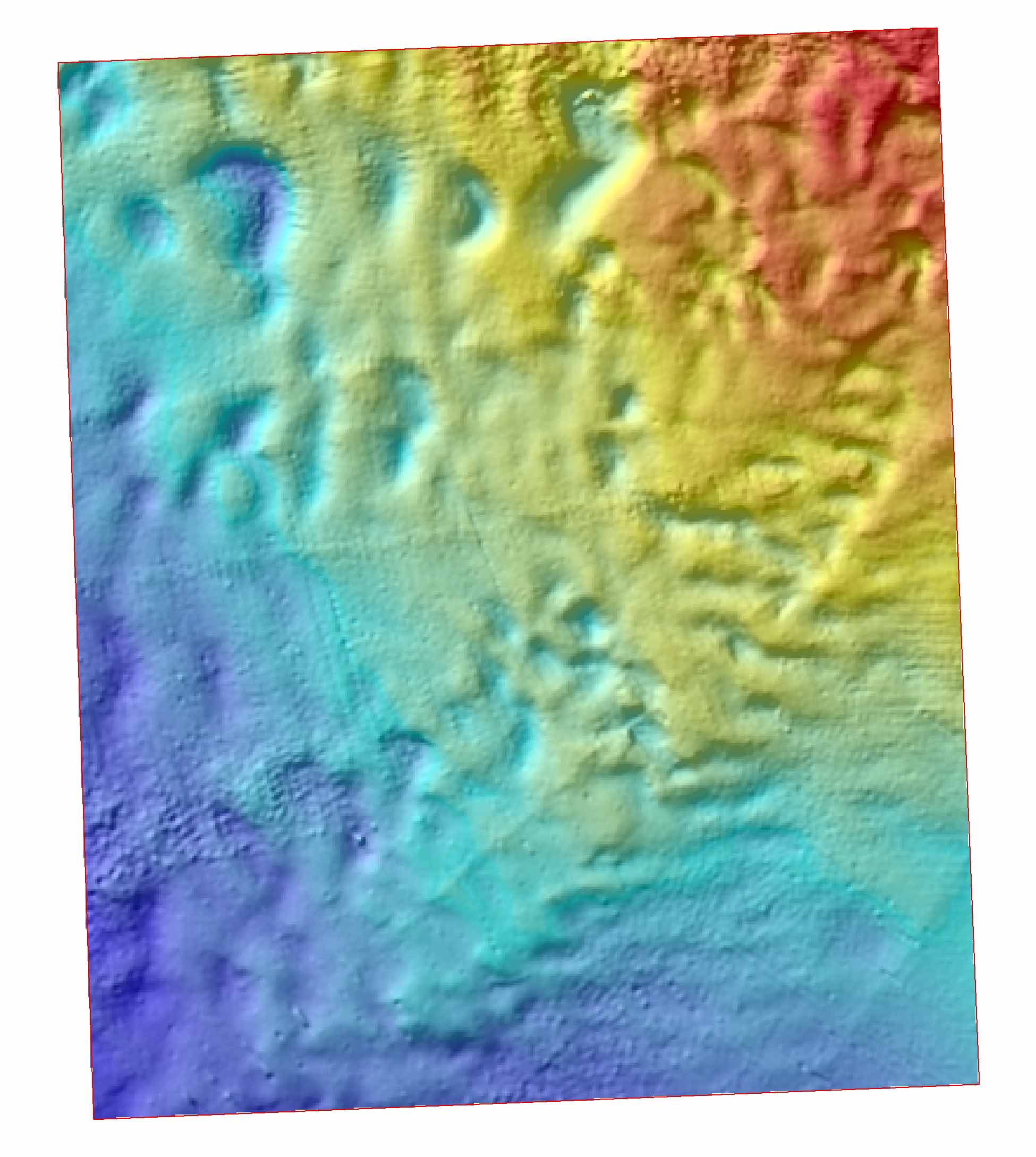
Detail of the seabed forms (Mega Dunes) of the Gulf of Cádiz (5 km width x 6 km long). Data coming from "Contouriber1 Cruise". Principal Investigators: Francisco Javier Hernández Molina (Coordinator, University of Vigo), Gemma Ercilla (CSIC), Teresa Medialdea (IGME).
owner
: {{md.getOwnername()}}
{{'mdStatusRecord' | translate}}: {{('mdStatus-' + md.mdStatus) | translate}}
| Date |
2018-09-28T00:00:00
|
| Date type |
Creation:
Date identifies when the resource was brought into existence
|
| Date |
2018-10-02T00:00:00
|
| Date type |
Revision:
Date identifies when the resource was examined or re-examined and improved or
amended
|
| Unique resource identifier |
igme_201009_HR_Contou1_1_GoC |
| Organisation name |
IGME, Geological Survey of Spain |
| Voice |
+34 913 495700 |
| Delivery point |
C/Rios Rosas 23 |
| City |
Madrid |
| Postal code |
28003 |
| Country |
Spain |
| Electronic mail address |
igme@igme.es
|
| Linkage |
http://www.igme.es
|
| Role |
Originator:
Party who created the resource
|
| Organisation name |
ICM-CSIC/ Institute of Marine Sciences |
| Voice |
+34 932 309500 |
| Delivery point |
Paseo Marítimo de la Barceloneta, 37-49 |
| City |
Barcelona |
| Postal code |
08003 |
| Country |
Spain |
| Electronic mail address |
secredir@icm.csic.es
|
| Linkage |
http://www.icm.csic.es
|
| Role |
Originator:
Party who created the resource
|
| Organisation name |
Universidad de Vigo |
| Voice |
+34 986 812 000 |
| Delivery point |
Campus Universitario 36310 |
| City |
Vigo (Pontevedra) |
| Postal code |
36310 |
| Country |
Spain |
| Electronic mail address |
informacion@uvigo.es
|
| Linkage |
http://www.uvigo.es/
|
| Role |
Originator:
Party who created the resource
|
| Organisation name |
IGME, Geological Survey of Spain |
| Voice |
+34 913 495700 |
| Delivery point |
C/Rios Rosas 23 |
| City |
Madrid |
| Postal code |
28003 |
| Country |
Spain |
| Electronic mail address |
igme@igme.es
|
| Linkage |
http://www.igme.es
|
| Role |
Custodian:
Party that accepts accountability and responsability for the data and ensures
appropriate care and maintenance of the resource
|
| Parameter Discovery Vocabulary (P02) |
Bathymetry and Elevation
|
| SeaDataNet device categories |
multi-beam echosounders
|
| Positioning devices |
Differential Global Positioning System receivers
|
| Vertical Datum |
Lowest Astronomical Tide
|
| Project name |
EMODnet HRSM
|
| Thèmes Sextant |
/Physical Environment/Bathymetry/Digital Terrain Model
|
| GDI-Vlaanderen Trefwoorden |
Metadata GDI-Vl-conform
|
| Distance |
0.015625 Arc minute |
| Language |
English |
| Character set |
UTF8:
8-bit variable size UCS Transfer Format, based on ISO/IEC 10646
|
| Topic category code |
|
| Hierarchy level |
Dataset:
Information applies to the dataset
|
| Hierarchy level |
Software:
Information applies to a computer program or routine
|
| Hierarchy level |
Property type:
Information applies to a property type
|
| Other |
software |
| Record |
2 - MBES low frequency (lower than 100kHz) (similar than 1+2%d) |
|
| Statement |
EMODnet processing methodology using Globe software |
| Access constraints |
Creative Commons Attribution 4.0 International:
Creative Commons Attribution 4.0 International
|
| Use constraints |
Other restrictions:
Limitation not listed
|
| Other constraints |
DO NOT USE FOR NAVIGATION |
|
|
|
 EMODnet Product Catalogue
}})