 EMODnet product catalogue
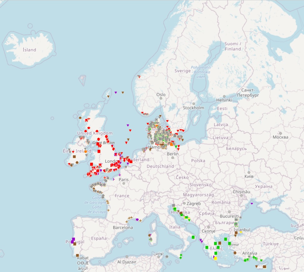
EMODnet Human Activities, Submerged Prehistoric Archeology
The dataset has been developped under the SPLASHCOS EU project, involving 20 EU Member States plus Norway, Russia, Ukraine and Switzerland. SPLASHCOS - Submerged Prehistoric Archaeology and Landscapes of the Continental Shelf - is a four-year research network (2009 to 2013) funded by the European Commission under its COST program (Cooperation in Science and Technology) as COST Action TD0902.
Its aim is to bring together archaeologists, marine geoscientists, heritage agencies, and commercial and industrial organizations interested in researching, managing and preserving the archives of archaeological and palaeoclimatic information locked up on the drowned prehistoric landscapes of the European continental shelf, and to disseminate that knowledge to a wider audience.
Simple
- Date (Creation)
- 2009-01-01
- Citation identifier
- Emodnet_Human_Activities_wrecks_WGS
- Point of contact
-
Organisation name Individual name Electronic mail address Role SPLASHCOS project
Point of contact
-
GEMET - INSPIRE themes, version 1.0
-
-
Protected sites
-
-
INSPIRE - Feature Concept Dictionary, version 3
-
-
Protected Site
-
-
GEMET - Concepts, version 2.4
-
-
culture (society)
-
- Use limitation
-
No access to
- Use limitation
-
No access to exact position of sites
- Access constraints
- Other restrictions
- Other constraints
-
the protection of sites of high heritage value
- Language
- English
- Topic category
-
- Utilities communication
))
))
))
))
))
- Begin date
- 2009-01-01
- Distribution format
-
Name Version unknown
unknown
- OnLine resource
-
Protocol Linkage Name WWW:LINK-1.0-http--link
https://emodnet.ec.europa.eu/en/human-activities EMODnet Human Activities
- Hierarchy level
- Dataset
Conformance result
- Title
-
COMMISSION REGULATION (EC) No 1205/2008 of 3 December 2008 implementing Directive 2007/2/EC of the European Parliament and of the Council as regards metadata
- Date
- 2008-12-04
- Explanation
-
See the referenced specification
- Pass
- Yes
Conformance result
- Title
-
Corrigendum to INSPIRE Metadata Regulation published in the Official Journal of the European Union, L 328, page 83
- Date
- 2009-12-15
- Explanation
-
See the referenced specification
- Pass
- Yes
Conformance result
- Title
-
Commission Regulation (EU) No 1089/2010 of 23 November 2010 implementing Directive 2007/2/EC of the European Parliament and of the Council as regards interoperability of spatial data sets and services
- Date
- 2010-12-08
- Explanation
-
See the referenced specification
- Statement
-
Data are provided by the SPLASHCOS project partners, who are national institutions of 24 countries. Quality and validity of data are ensured by scientists in charge of collecting information in the different countries.
Metadata
- File identifier
- a24c8be1-08b5-48ed-b8c5-85b7a8c24d05 XML
- Metadata language
- English
- Character set
- MD_CharacterSetCode_utf8
- Hierarchy level
- Dataset
- Date stamp
- 2024-02-14T14:35:19.697467Z
- Metadata standard name
-
ISO19115
- Metadata standard version
-
2003/Cor.1:2006
- Metadata author
-
Organisation name Individual name Electronic mail address Role AND International
Point of contact
),POLYGON((180%2041.19,180%2081.86,-180%2081.86,-180%2041.19,180%2041.19)),POLYGON((31.15%2057.97,31.15%2071.19,4.64%2071.19,4.64%2057.97,31.15%2057.97)),POLYGON((40.23%2044.39,40.23%2052.38,22.14%2052.38,22.14%2044.39,40.23%2044.39)),POLYGON((10.49%2045.82,10.49%2047.81,5.96%2047.81,5.96%2045.82,10.49%2045.82))))
