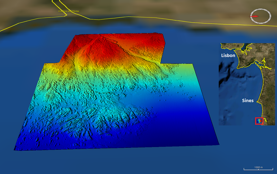
3288_Mineplat_HR_B - Alentejo shelf - paleo-channels - 4m res.
High resolution (1/448 minute ~ 4m) composite bathymetry dataset from the Mineplat 3 and Mineplat 4 cruises onboard IPMA RV Noruega. Portugal southern continental shelf, off Alentejo coast, 8 to 20 June 2018 and 24 March to 4 April 2019. Depths between 20 and 115m. During Mineplat 3 cruise high resolution multichannel seismics and magnetic data acquisition was performed during the daytime and multibeam mapping 24h/24h, with a Reson T50-P multibeam echosounder. Mineplat 4 cruise comprised seabed sediments sampling during daytime and multibeam mapping during the night. Depths are referenced to the Portuguese Chart Datum (2m below MSL), horizontal coordinates in the WGS84 reference frame. Position and attitude data (GNSS+Inertial via Applanix OceanMaster POSMV) was post-processed with POSPAC.
owner
: {{md.getOwnername()}}
{{'mdStatusRecord' | translate}}: {{('mdStatus-' + md.mdStatus) | translate}}
Alternate title
KN172L08 SeaBeam 3012-P1 Bathymetry Grid
Date
2020-11-18T00:00:00
Date type
Creation:
Date identifies when the resource was brought into existence
Date
2020-11-19T00:00:00
Date type
Revision:
Date identifies when the resource was examined or re-examined and improved or
amended
Unique resource identifier
Mineplat_HR_B
Organisation name
Portuguese Institute of Ocean and Atmosphere
Voice
(+351) 218 447 000
Delivery point
Rua C do Aeroporto
City
Lisbon
Postal code
1749-077
Country
Portugal
Electronic mail address
info@ipma.pt
Linkage
http://www.ipma.pt
Role
Originator:
Party who created the resource
Organisation name
Portuguese Institute of Ocean and Atmosphere
Voice
(+351) 218 447 000
Delivery point
Rua C do Aeroporto
City
Lisbon
Postal code
1749-077
Country
Portugal
Electronic mail address
info@ipma.pt
Linkage
http://www.ipma.pt
Role
Custodian:
Party that accepts accountability and responsability for the data and ensures
appropriate care and maintenance of the resource
Project name
EMODNet Bathymetry
SeaDataNet device categories
multi-beam echosounders
|
acoustic backscatter sensors
SeaDataNet device categories
Differential Global Positioning System receivers
Parameter Discovery Vocabulary (P02)
Bathymetry and Elevation
GEMET - INSPIRE themes, version 1.0
GDI-Vlaanderen Trefwoorden
Metadata GDI-Vl-conform
Spatial representation type
Grid:
Grid data is used to represent geographic data
Distance
0.0022321 Arc minute
Language
English
Character set
UTF8:
8-bit variable size UCS Transfer Format, based on ISO/IEC 10646
Topic category code
Unique resource identifier
WGS 84 (EPSG:4326)
Codespace
EPSG
Hierarchy level
Dataset:
Information applies to the dataset
Hierarchy level
Feature:
Information applies to a feature
Hierarchy level
Software:
Information applies to a computer program or routine
Hierarchy level
Property type:
Information applies to a property type
Hierarchy level
Dataset:
Information applies to the dataset
Other
software
Record
4 - MBES High frequency (higher that 100kHz) (1+0.5%d)
Statement
EMODnet processing methodology using Globe software
Access constraints
Creative Commons Attribution 4.0 International:
Creative Commons Attribution 4.0 International
Use constraints
Other restrictions:
Limitation not listed
Other constraints
DO NOT USE FOR NAVIGATION
 EMODnet Product Catalogue
}})