 EMODnet Product Catalogue
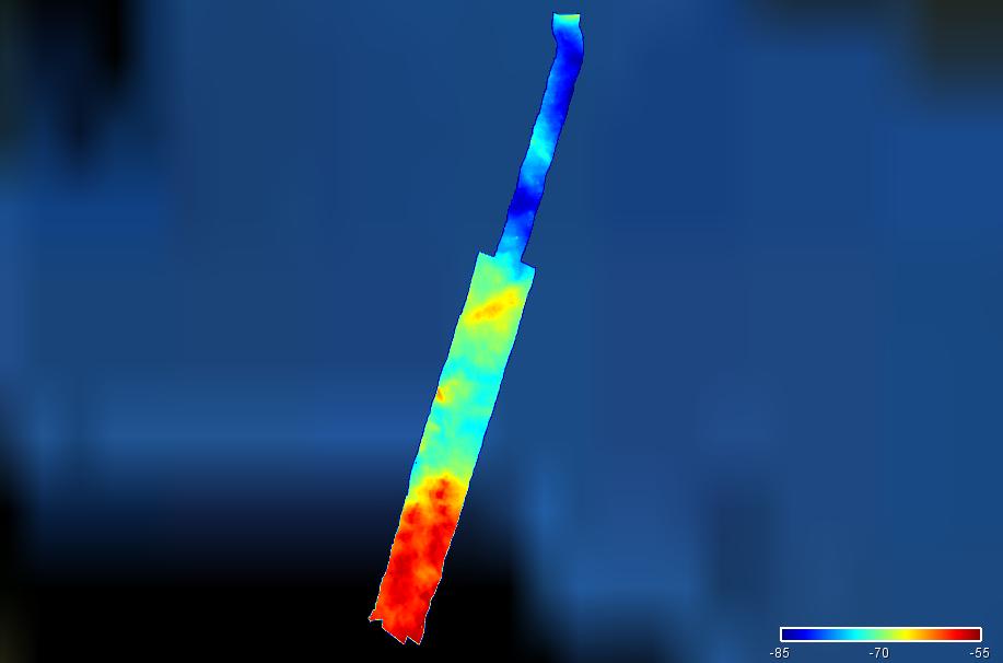
3289_ESTUNLAR_Skopunarfjordur_B_2015
Multibeam bathymetry in Skopunarfjørður, Faroe Islands.
owner : {{md.getOwnername()}}
{{'mdStatusRecord' | translate}}: {{('mdStatus-' + md.mdStatus) | translate}}
- Identification
- Content
- ReferenceSystem
- Quality
- DomainConsistancy
- Constraints
- Distribution
- Meta-metadata
- ObjectCatalogue
| Date | 2015-05-01 |
|---|---|
| Date type | Creation: Date identifies when the resource was brought into existence |
| Date | 2015-05-01 |
| Date type | Revision: Date identifies when the resource was examined or re-examined and improved or amended |
| Unique resource identifier | FO_ESTSFB_2015 |
Point of contact
| Organisation name | Jardfeingi, the Faroe Islands Earth and Energy Directorate |
|---|---|
| Voice | +298 357000 |
| Delivery point | Brekkutún 1 Postsmoga 3059 |
| City | Tórshavn |
| Postal code | FO 110 |
| Country | Faroe Islands |
| Electronic mail address | jardfeingi@jardfeingi.fo |
| Linkage | http://www.jardfeingi.fo/ |
| Role | Originator: Party who created the resource |
Point of contact
| Organisation name | Jardfeingi, the Faroe Islands Earth and Energy Directorate |
|---|---|
| Voice | +298 357000 |
| Delivery point | Brekkutún 1 Postsmoga 3059 |
| City | Tórshavn |
| Postal code | FO 110 |
| Country | Faroe Islands |
| Electronic mail address | jardfeingi@jardfeingi.fo |
| Linkage | http://www.jardfeingi.fo/ |
| Role | Custodian: Party that accepts accountability and responsability for the data and ensures appropriate care and maintenance of the resource |
Descriptive keywords
| Spatial representation type | Grid: Grid data is used to represent geographic data |
|---|
Spatial resolution
| Denominator | 5000 |
|---|
Spatial resolution
| Distance | 0.00390625 Arc minute |
|---|
| Language | English |
|---|---|
| Character set | UTF8: 8-bit variable size UCS Transfer Format, based on ISO/IEC 10646 |
| Topic category code |
|
| Hierarchy level | Dataset: Information applies to the dataset |
|---|---|
| Hierarchy level | Software: Information applies to a computer program or routine |
| Hierarchy level | Property type: Information applies to a property type |
| Other | software |
Absolute external positional accuracy
Quantitative result
|
|||
Absolute external positional accuracy
Quantitative result
|
|||
mdLegalAndSecurityConstraintsSection
Resource constraints
|
|||||||||||
| Distribution format | XYZ Ascii (Version: 1.0) | ||||||||||||||||||||||||
|---|---|---|---|---|---|---|---|---|---|---|---|---|---|---|---|---|---|---|---|---|---|---|---|---|---|
Transfer options
|
|||||||||||||||||||||||||
| File identifier | SDN_CPRD_3289_FO_ESTSFB_2015 |
|---|---|
| Metadata language | English |
| Character set | UTF8: 8-bit variable size UCS Transfer Format, based on ISO/IEC 10646 |
| Hierarchy level name | Composite Product Record |
| Date stamp | 2025-03-07T14:09:30.537549Z |
| Metadata standard name | ISO 19115:2003/19139 - EMODNET - BATHYMETRY |
| Metadata standard version | 1.0 |
Overviews
extent
- geoDesc
- {{d}}
- geoBox
-
}})
- geoDescCode
- {{mdView.current.record.geoDescCode}}
tempExtent
- creationDate
- publicationDate
- revisionDate
- tempExtentBegin
Associated resources
Not available