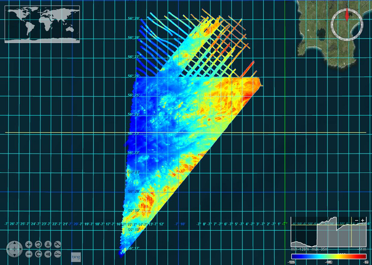
2012/9_MS: Argyll Array: South-west of Tiree: Priority Area: 1/128
This marine geophysical and multibeam survey was undertaken by British Geological Survey on behalf of Marine Scotland utilising the Northern Lighthouse Board vessel NLV Polestar, it took place in July/August 2012 off south-west Tiree. The purpose was to further our understanding of Scotland’s marine environment, increase the efficiency of use of public resources, enhance the safety of those at sea and contribute to new policy priorities such as marine protected areas, wider conservation measures, marine planning and renewable. Bathymetric data was collected using a Kongsberg EM3002D dual head, multibeam system. Data was acquired using a Kongsberg SIS operating system, logging raw .ALL files. This data was processed offline by BGS using CARIS HIPS and SIPS 7.1 SP2.
owner
: {{md.getOwnername()}}
{{'mdStatusRecord' | translate}}: {{('mdStatus-' + md.mdStatus) | translate}}
| Date |
2017-12-07
|
| Date type |
Creation:
Date identifies when the resource was brought into existence
|
| Date type |
Revision:
Date identifies when the resource was examined or re-examined and improved or
amended
|
| Unique resource identifier |
BGS_2012_9_Tiree_PriorityArea |
| Organisation name |
British Geological Survey, Edinburgh |
| Delivery point |
The Lyell Centre |
| City |
Edinburgh |
| Postal code |
EH14 4AP |
| Country |
United Kingdom |
| Electronic mail address |
OffshoreData@bgs.ac.uk
|
| Linkage |
http://www.bgs.ac.uk/
|
| Role |
Originator:
Party who created the resource
|
| Organisation name |
British Geological Survey, Edinburgh |
| Delivery point |
The Lyell Centre |
| City |
Edinburgh |
| Postal code |
EH14 4AP |
| Country |
United Kingdom |
| Electronic mail address |
OffshoreData@bgs.ac.uk
|
| Linkage |
http://www.bgs.ac.uk/
|
| Role |
Custodian:
Party that accepts accountability and responsability for the data and ensures
appropriate care and maintenance of the resource
|
| Parameter Discovery Vocabulary (P02) |
Bathymetry and Elevation
|
| SeaDataNet device categories |
multi-beam echosounders
|
| Positioning devices |
Differential Global Positioning System receivers
|
| Vertical Datum |
UK Admiralty Chart Datum
|
| Project name |
EMODnet HRSM
|
| Thèmes Sextant |
/Physical Environment/Bathymetry/Digital Terrain Model
|
| GDI-Vlaanderen Trefwoorden |
Metadata GDI-Vl-conform
|
| Spatial representation type |
Grid:
Grid data is used to represent geographic data
|
| Distance |
0.0078125 Arc minute |
| Language |
English |
| Character set |
UTF8:
8-bit variable size UCS Transfer Format, based on ISO/IEC 10646
|
| Topic category code |
|
| Unique resource identifier |
WGS 84 / UTM zone 29N (EPSG:32629) |
| Codespace |
EPSG |
| Hierarchy level |
Dataset:
Information applies to the dataset
|
| Hierarchy level |
Software:
Information applies to a computer program or routine
|
| Hierarchy level |
Property type:
Information applies to a property type
|
| Other |
software |
| Record |
4 - MBES High frequency (higher that 100kHz) (1+0.5%d) |
|
| Statement |
EMODnet processing methodology using Globe software |
| Access constraints |
Creative Commons Attribution 4.0 International:
Creative Commons Attribution 4.0 International
|
| Use constraints |
Other restrictions:
Limitation not listed
|
| Other constraints |
DO NOT USE FOR NAVIGATION |
|
|
|
| Organisation name |
British Geological Survey, Edinburgh |
| Delivery point |
The Lyell Centre |
| City |
Edinburgh |
| Postal code |
EH14 4AP |
| Country |
United Kingdom |
| Electronic mail address |
OffshoreData@bgs.ac.uk
|
| Linkage |
http://www.bgs.ac.uk/
|
| Role |
Distributor:
Party who distributes the resource
|
|
|
|
 EMODnet Product Catalogue
}})