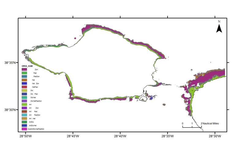
Azores: Faial and western Pico dominant macroalgae
Spatial distribution of the dominant benthic macroalgae resulting from predictive models for the infralittoral rocky seafloor around Faial island and neighbouring passage to Pico. Tempera, F. (2008). Benthic Habitats of the Extended Faial Island Shelf and their Relationship to Geologic, Oceanographic and Infralittoral Biologic Features. Ph.D. thesis. University of St. Andrews. 348 pp. http://hdl.handle.net/10023/726.
owner : {{md.getOwnername()}}
{{'mdStatusRecord' | translate}}: {{('mdStatus-' + md.mdStatus) | translate}}
- Identification
- Content
- ReferenceSystem
- Quality
- DomainConsistancy
- Constraints
- Distribution
- Meta-metadata
- ObjectCatalogue
| Alternate title | PT100001 |
|---|---|
| Date | 2012-10-17T15:12:00 |
| Date type | Publication: Date identifies when the resource was issued |
| Edition | Version 1.0 |
| Purpose | Research supported by MeshAtlantic project |
|---|---|
| Status | Historical archive: Data has been stored in an offline storage facility |
Point of contact
| Individual name | Patricia Amorim & Fernando Tempera |
|---|---|
| Organisation name | DOP/IMAR University of the Azores |
| Delivery point | Rua Prof. Dr. Frederico Machado, 4 |
| City | HORTA |
| Postal code | 9900-361 |
| Country | Portugal |
| Electronic mail address | pamorim@uac.pt; tempera@uac.pt |
| Role | Point of contact: Party who can be contacted for acquiring knowledge about or acquisition of the resource |
| Maintenance and update frequency | Not planned: There are no plans to update the data |
|---|
Descriptive keywords
| GEMET - INSPIRE themes, version 1.0 | |
|---|---|
| GDI-Vlaanderen Trefwoorden | Metadata GDI-Vl-conform |
| Other keywords | Azores |
| Other keywords | Marine habitat mapping |
| Spatial representation type | Grid: Grid data is used to represent geographic data |
|---|
Spatial resolution
| Denominator | 10000 |
|---|
| Character set | UTF8: 8-bit variable size UCS Transfer Format, based on ISO/IEC 10646 |
|---|---|
| Topic category code |
|
Reference System Information
| Unique resource identifier | WGS 1984 |
|---|
| Hierarchy level | Dataset: Information applies to the dataset |
|---|
mdLegalAndSecurityConstraintsSection
Resource constraints
|
|||||
| Distribution format | GRID (Version: ArcGIS 10) | ||||||||||||||||||||||||||||||||
|---|---|---|---|---|---|---|---|---|---|---|---|---|---|---|---|---|---|---|---|---|---|---|---|---|---|---|---|---|---|---|---|---|---|
Transfer options
|
|||||||||||||||||||||||||||||||||
| File identifier | a5214486-dbd4-4b8b-b960-694d3fd4af4c | ||||||||||||||
|---|---|---|---|---|---|---|---|---|---|---|---|---|---|---|---|
| Character set | UTF8: 8-bit variable size UCS Transfer Format, based on ISO/IEC 10646 | ||||||||||||||
| Date stamp | 2020-01-15T12:29:29 | ||||||||||||||
| Metadata standard name | ISO 19115:2003/19139 | ||||||||||||||
| Metadata standard version | 1.0 | ||||||||||||||
Contact
|
|||||||||||||||
Overviews

thumbnail

large_thumbnail
extent
- geoDesc
- {{d}}
- geoBox
-
- geoDescCode
- {{mdView.current.record.geoDescCode}}
tempExtent
- creationDate
- publicationDate
- revisionDate
- tempExtentBegin
Associated resources
Not available
 EMODnet Product Catalogue
}})