 EMODnet Product Catalogue
Concentration of organic matter in sediments
Type of resources
Available actions
Topics
Keywords
Contact for the resource
Provided by
Years
Formats
Representation types
-
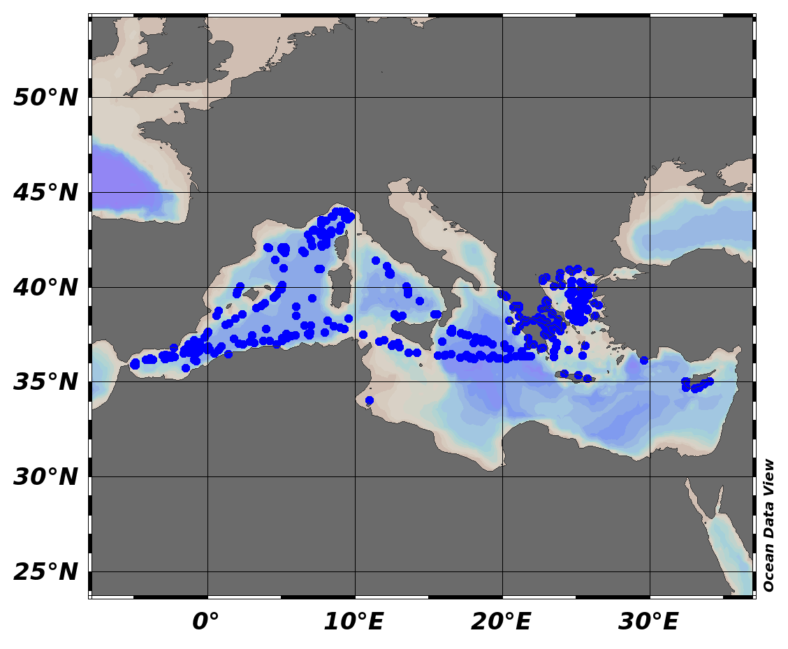
EMODnet Chemistry aims to provide access to marine chemistry data sets and derived data products concerning eutrophication, ocean acidification and contaminants. The chemicals chosen reflect importance to the Marine Strategy Framework Directive (MSFD). This regional aggregated dataset contains all unrestricted EMODnet Chemistry data on contaminants (24 parameters), and covers the Mediterranean Sea with 4517 CDI records divided per matrices: 520 biota profiles, 560 water profiles, 3437 sediment (26 Vertical profiles and 3411 Time series). In the water dataset, the vertical profiles temporal range is from 1974-09-12 to 2015-09-14. In sediment dataset, vertical profiles temporal range is from 2010-08-02 to 2014-09-28 and time series temporal range is from 1981-06-27 to 2018-08-02. In biota time series temporal range is from 1979-03-29 to 2017-03-15. Data were aggregated and quality controlled by ‘Hellenic Centre for Marine Research, Hellenic National Oceanographic Data Centre (HCMR/HNODC)’ from Greece. Regional datasets concerning contaminants are automatically harvested. Parameter names in these datasets are based on P01, BODC Parameter Usage Vocabulary, which is available at: http://seadatanet.maris2.nl/bandit/browse_step.php . Each measurement value has a quality flag indicator. The resulting data collections for each Sea Basin are harmonised, and the collections are quality controlled by EMODnet Chemistry Regional Leaders using ODV Software and following a common methodology for all Sea Regions. Harmonisation means that: (1) unit conversion is carried out to express contaminant concentrations with a limited set of measurement units (according to EU directives 2013/39/UE; Comm. Dec. EU 2017/848) and (2) merging of variables described by different “local names” ,but corresponding exactly to the same concepts in BODC P01 vocabulary. The harmonised dataset can be downloaded as ODV spreadsheet (TXT file), which is composed of metadata header followed by tab separated values. This worksheet can be imported to ODV Software for visualisation (More information can be found at: https://www.seadatanet.org/Software/ODV ). The same dataset is offered also as XLSX file in a long/vertical format, in which each P01 measurement is a record line. Additionally, there are a series of columns that split P01 terms in subcomponents (measure, substance, CAS number, matrix...).This transposed format is more adapted to worksheet applications users (e.g. LibreOffice Calc). The 24 parameter names in this metadata record are based on P02, SeaDataNet Parameter Discovery Vocabulary, which is available at: http://seadatanet.maris2.nl/v_bodc_vocab_v2/vocab_relations.asp?lib=P02 . Detailed documentation will be published soon. The original datasets can be searched and downloaded from EMODnet Chemistry Download Service: https://emodnet-chemistry.maris.nl/search
-
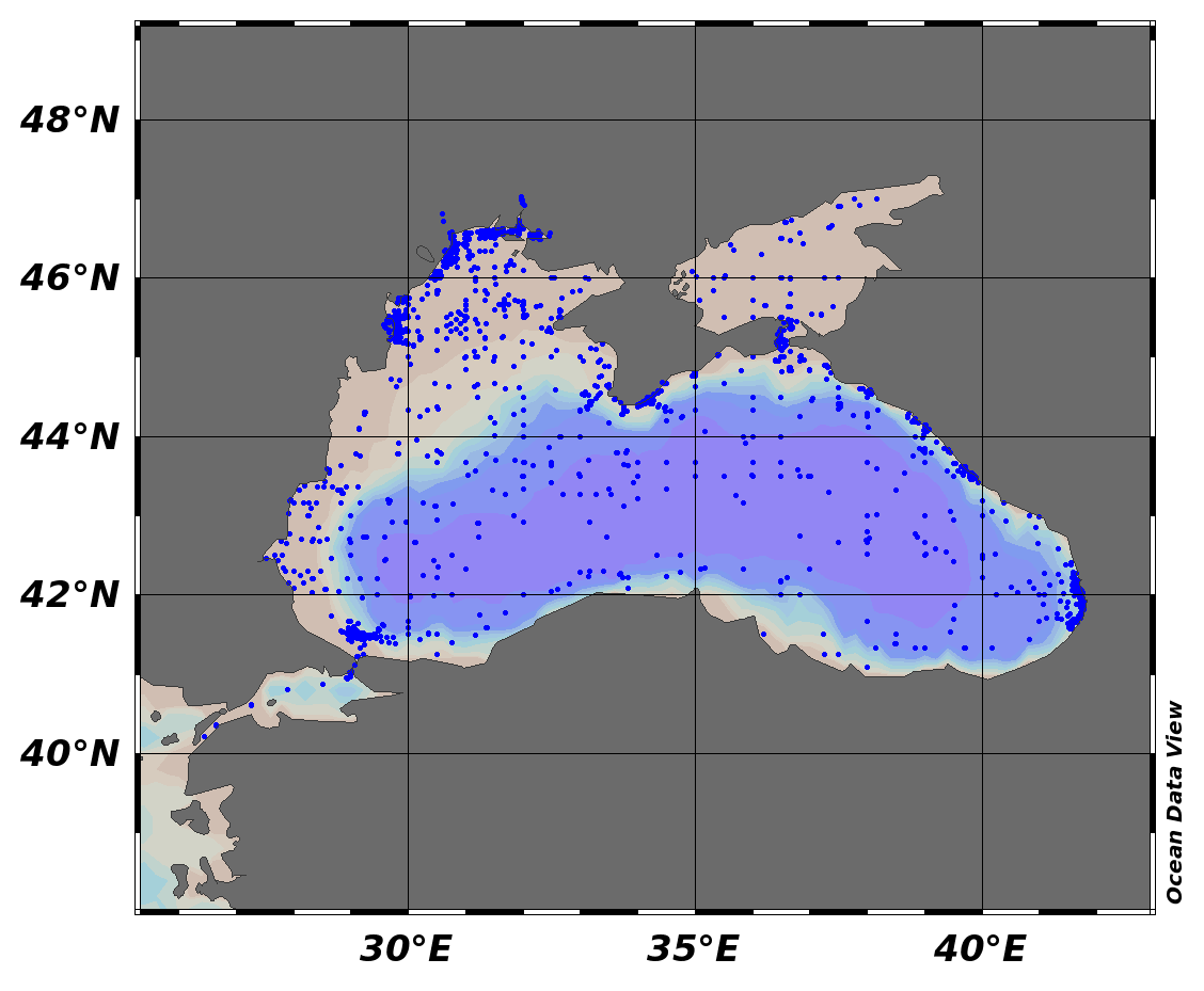
EMODnet Chemistry aims to provide access to marine chemistry data sets and derived data products concerning eutrophication, ocean acidification and contaminants. The chemicals chosen reflect importance to the Marine Strategy Framework Directive (MSFD). This regional aggregated dataset contains all unrestricted EMODnet Chemistry data on contaminants (48 parameters), and covers the Black Sea with 21504 CDI records divided per matrices: 7 biota profiles, 19677 water profiles, 1820 sediment profiles. Vertical profiles temporal range is from 1974-08-24 to 2017-10-06. Data were aggregated and quality controlled by ‘National Institute for Marine Research and Development "Grigore Antipa"’ from Romania. Regional datasets concerning contaminants are automatically harvested. Parameter names in these datasets are based on P01, BODC Parameter Usage Vocabulary, which is available at: http://seadatanet.maris2.nl/bandit/browse_step.php . Each measurement value has a quality flag indicator. The resulting data collections for each Sea Basin are harmonised, and the collections are quality controlled by EMODnet Chemistry Regional Leaders using ODV Software and following a common methodology for all Sea Regions. Harmonisation means that: (1) unit conversion is carried out to express contaminant concentrations with a limited set of measurement units (according to EU directives 2013/39/UE; Comm. Dec. EU 2017/848) and (2) merging of variables described by different “local names”, but corresponding exactly to the same concepts in BODC P01 vocabulary. The harmonised dataset can be downloaded as ODV spreadsheet (TXT file), which is composed of metadata header followed by tab separated values. This worksheet can be imported to ODV Software for visualisation (More information can be found at: https://www.seadatanet.org/Software/ODV ). The same dataset is offered also as XLSX file in a long/vertical format, in which each P01 measurement is a record line. Additionally, there are a series of columns that split P01 terms in subcomponents (measure, substance, CAS number, matrix...).This transposed format is more adapted to worksheet applications users (e.g. LibreOffice Calc). The 48 parameter names in this metadata record are based on P02, SeaDataNet Parameter Discovery Vocabulary, which is available at: http://seadatanet.maris2.nl/v_bodc_vocab_v2/vocab_relations.asp?lib=P02 . Detailed documentation will be published soon. The original datasets can be searched and downloaded from EMODnet Chemistry Download Service: https://emodnet-chemistry.maris.nl/search
-

EMODnet Chemistry aims to provide access to marine chemistry data sets and derived data products concerning eutrophication, ocean acidification and contaminants. The chemicals chosen reflect importance to the Marine Strategy Framework Directive (MSFD). This regional aggregated dataset contains all unrestricted EMODnet Chemistry data on contaminants (20 parameters), and covers the North East Atlantic Ocean with 2400 CDI records divided per matrices: 122 in biota (as time series), 1689 in water (as vertical profiles), 589 in sediment (478 Vertical profiles and 111 Time series). Vertical profiles temporal range is from 1970-07-29 to 2017-02-28. Time series temporal range is from 1979-02-28 to 2014-10-21. Data were aggregated and quality controlled by ‘IFREMER / IDM / SISMER - Scientific Information Systems for the SEA’ from France. Regional datasets concerning contaminants are automatically harvested. Parameter names in these datasets are based on P01, BODC Parameter Usage Vocabulary, which is available at: http://seadatanet.maris2.nl/bandit/browse_step.php . Each measurement value has a quality flag indicator. The resulting data collections for each Sea Basin are harmonised, and the collections are quality controlled by EMODnet Chemistry Regional Leaders using ODV Software and following a common methodology for all Sea Regions. Harmonisation means that: (1) unit conversion is carried out to express contaminant concentrations with a limited set of measurement units (according to EU directives 2013/39/UE; Comm. Dec. EU 2017/848) and (2) merging of variables described by different “local names” ,but corresponding exactly to the same concepts in BODC P01 vocabulary. The harmonised dataset can be downloaded as ODV spreadsheet (TXT file), which is composed of metadata header followed by tab separated values. This worksheet can be imported to ODV Software for visualisation (More information can be found at: https://www.seadatanet.org/Software/ODV ). The same dataset is offered also as XLSX file in a long/vertical format, in which each P01 measurement is a record line. Additionally, there are a series of columns that split P01 terms in subcomponents (measure, substance, CAS number, matrix...).This transposed format is more adapted to worksheet applications users (e.g. LibreOffice Calc). The 20 parameter names in this metadata record are based on P02, SeaDataNet Parameter Discovery Vocabulary, which is available at: http://seadatanet.maris2.nl/v_bodc_vocab_v2/vocab_relations.asp?lib=P02 . Detailed documentation will be published soon. The original datasets can be searched and downloaded from EMODnet Chemistry Download Service: https://emodnet-chemistry.maris.nl/search
-

EMODnet Chemistry aims to provide access to marine chemistry data sets and derived data products concerning eutrophication, ocean acidification and contaminants. The chemicals chosen reflect importance to the Marine Strategy Framework Directive (MSFD). This regional aggregated dataset contains all unrestricted EMODnet Chemistry data on contaminants (59 parameters), and covers the North Sea with 34978 CDI records divided per matrices: 3909 biota time series, 28071 water profiles, 2998 sediment profiles. Vertical profiles temporal range is from 1970-02-17 to 2017-10-26. Time series temporal range is from 1979-02-26 to 2017-02-28. Data were aggregated and quality controlled by ‘Aarhus University, Department of Bioscience, Marine Ecology Roskilde from Denmark. Regional datasets concerning contaminants are automatically harvested. Parameter names in these datasets are based on P01, BODC Parameter Usage Vocabulary, which is available at: http://seadatanet.maris2.nl/bandit/browse_step.php . Each measurement value has a quality flag indicator. The resulting data collections for each Sea Basin are harmonised, and the collections are quality controlled by EMODnet Chemistry Regional Leaders using ODV Software and following a common methodology for all Sea Regions. Harmonisation means that: (1) unit conversion is carried out to express contaminant concentrations with a limited set of measurement units (according to EU directives 2013/39/UE; Comm. Dec. EU 2017/848) and (2) merging of variables described by different “local names” ,but corresponding exactly to the same concepts in BODC P01 vocabulary. The harmonised dataset can be downloaded as ODV spreadsheet (TXT file), which is composed of metadata header followed by tab separated values. This worksheet can be imported to ODV Software for visualisation (More information can be found at: https://www.seadatanet.org/Software/ODV ). The same dataset is offered also as XLSX file in a long/vertical format, in which each P01 measurement is a record line. Additionally, there are a series of columns that split P01 terms in subcomponents (measure, substance, CAS number, matrix...).This transposed format is more adapted to worksheet applications users (e.g. LibreOffice Calc). The 59 parameter names in this metadata record are based on P02, SeaDataNet Parameter Discovery Vocabulary, which is available at: http://seadatanet.maris2.nl/v_bodc_vocab_v2/vocab_relations.asp?lib=P02 . Detailed documentation will be published soon. The original datasets can be searched and downloaded from EMODnet Chemistry Download Service: https://emodnet-chemistry.maris.nl/search
-
The ReZoEnv field campaign was conducted at 9 sites distributed within contrasted seagrass (Zostera notlei) meadows in the Arcachon Bay. This multi-parameter survey was conducted during one year (November 2015 – November 2016). Water levels, temperature and light were recorded every 10 minutes. While bed sediment characteristics (granulometry, water content, organic matter content), seagrass characteristics (coverage, biometry, chlorophyll and CNP content) were measured monthly. Additionally, wind-wave parameters were obtained from high frequency pressure sensor at 4 sites, every 20 minutes. List of sites : ANDE : 44.745091 N, 1.121366 O FONT : 44.722631 N, 1.080133 O GAIL : 44.662573 N, 1.099575 O GARR : 44.705132 N, 1.121562 O HAUT : 44.729331 N, 1.15608 O ILE : 44.683117 N, 1.162716 O JACQ : 44.724563 N, 1.181109 O PASS : 44.689927 N, 1.089491 O ROCH : 44.648529 N, 1.127736 O Important Note: This submission has been initially submitted to SEA scieNtific Open data Edition (SEANOE) publication service and received the recorded DOI. The metadata elements have been further processed (refined) in EMODnet Ingestion Service in order to conform with the Data Submission Service specifications.
-
The Green Edge project was designed to investigate the onset, life and fate of a phytoplankton spring bloom (PSB) in the Arctic Ocean. The lengthening of the ice-free period and the warming of seawater, amongst other factors, have induced major changes in arctic ocean biology over the last decades. Because the PSB is at the base of the Arctic Ocean food chain, it is crucial to understand how changes in the arctic environment will affect it. Green Edge was a large multidisciplinary collaborative project bringing researchers and technicians from 28 different institutions in seven countries, together aiming at understanding these changes and their impacts on the future. The fieldwork for the Green Edge project took place over two years (2015 and 2016) and was carried out from both an ice camp and a research vessel in the Baffin Bay, Canadian arctic. Here, we describe the data set obtained during the research cruise, which took place aboard the Canadian Coast Guard Ship (CCGS) Amundsen in spring 2016. Important Note: This submission has been initially submitted to SEA scieNtific Open data Edition (SEANOE) publication service and received the recorded DOI. The metadata elements have been further processed (refined) in EMODnet Ingestion Service in order to conform with the Data Submission Service specifications.
-
This data set is associated with the manuscript draft entitled "How is particulate organic carbon transported in the Congo-River-fed Submarine Canyon to the deep-sea"? accpeted for publication in the Journal EGU Biogeosciences on 18 August 2024. The dataset includes grain-size measurements, total organic carbon contents, carbon stable isotopes and radiocarbon ages on sediment samples collected in a sediment trap and multi-cores in the Congo Submarine Canyon at 2 km of water depth. Important Note: This submission has been initially submitted to SEA scieNtific Open data Edition (SEANOE) publication service and received the recorded DOI. The metadata elements have been further processed (refined) in EMODnet Ingestion Service in order to conform with the Data Submission Service specifications.
-
The purpose of this publication is to give access to the analytic data set which has been used in a paper submitted to the journal Marine Geology (Torelli et al., submitted). This paper proposes a general study of the organic matter (OM) distribution within the recent Quaternary sediments of the Mozambique Channel (southern part of the east African margins). The study was conducted in the framework of the PAMELA (PAssive Margin Exploration LAboratory) research project (Bourillet et al., 2013). This study is mainly based on Rock-Eval 6 (RE6) analyses of samples collected during several marine surveys: Pamela-Moz01 (Olu, 2014), Pamela-Moz04 (Jouet and Deville, 2015) and Pamela-Moz08 (Khripounoff, 2016; Fig. 1). 394 RE6 analyses were performed on samples collected with the Küllenberg corer (recovered core length up to 12 m) of the R/V Atalante (Pamela-Moz01 survey) and the Calypso corer (recovered core length up to 33 m) of the R/V Pourquoi Pas? (Pamela-Moz04 survey), 11 RE6 analyses on samples collected with an interface multicorer (30-40 cm maximum penetration), and 101 RE6 analyses on samples collected with sediment traps in moorings located 47 m above seabed. We provide here the whole RE6 analyses (Table 1) and the correlation made between RE6 analyses and LECO elemental analyses concerning the total carbon (Tables 2 and 3). The analysis of samples collected with particle traps within the deep-water areas of the Mozambique Basin has shown that the OM is transported by turbidite and/or contour currents and deposited while preserving Total Organic Carbon (TOC) contents between 1.5 and 3%Wt. However, the sedimentary OM is largely oxidized (Oxygen Index > 300 mg CO2/g TOC) and only a small amount of TOC (< 0.5%Wt) is preserved within the recent sediments of the distal area of the Zambezi turbidite system at water depths below 2500 m. Interface sediments sampled to a maximum depth of 40 cm, have shown intermediate TOC values between those collected in the particle traps and those from piston cores suggesting that the degradation of the OM is mainly active at the water-sediment interface. This OM oxidation and degradation process in the deep-water domains of the Mozambique Basin is probably due to the conjugate effects of low sediment accumulation rate and high permeability of the coarse-grained sediments but also to important bottom currents that promote the remobilization and the rearrangement of fine grained sediments. References Bourillet, J.F., Ferry, J.N., Bourges, P., 2013. PAMELA, Passive Margins Exploration Laboratories. https://dx.doi.org/10.18142/236. Jouet, G., Deville, E., 2015. PAMELA-MOZ04 cruise, R/V Pourquoi Pas? https://doi.org/10.17600/15000700. Khripounoff, A., 2017. PAMELA-MOZ08 cruise, R/V Antea. https://doi.org/10.17600/17003900. Olu, K, 2014. PAMELA-MOZ01 cruise, R/V L'Atalante, https://dx.doi.org/10.17600/14001000. Torelli, M., Battani, A., Pillot, D., Kohler, E., Lopes De Azevedo, J., Kowalewski, I., Pastor, L., Brandily, C., Schmidt, S., Jouet, G., Deville, E. (Submitted to Marine Geology). Organic matter distribution in modern sediments of the Mozambique Channel: Evidence for widespread oxidation processes in the deep-water domains. Important Note: This submission has been initially submitted to SEA scieNtific Open data Edition (SEANOE) publication service and received the recorded DOI. The metadata elements have been further processed (refined) in EMODnet Ingestion Service in order to conform with the Data Submission Service specifications.
-
Part of Deliverable 6.1 of GENIALG Project. Datasets used for parametrisation of models and evaluation of seaweed farm environmental footprint. Sediment samples collected using van veen grabs and analysed for granulometry and organic matter content. Locations and dates indicated on dataset. Records obtained at Ventry Harbour test farm between September 2017 and April 2019 during GENIALG project (project ID: 727892, GENIALG - GENetic diversity exploitation for Innovative Macro-ALGal biorefinery, http://genialgproject.eu/). GENIALG was funded by the European Union Horizon2020 programme. The remit of the work was assessing the environmental footprint and ecosystem services provided by seaweed aquaculture in Europe to provide best practice advice to industry.
-
In the Mediterranean deep-sea two scleractinian species, Lophelia pertusa (= Desmophyllum pertusum) and Madrepora oculata, make up the dominant structure-forming corals. The Lacaze-Duthiers canyon is the only French Mediterranean canyon where the two species L. pertusa and M. oculata have been observed living together in large quantities, the situation generally described for the biocoenosis of cold-water corals (CWC). In this canyon large colonies (more than 40 cm) of both species of scleractinians were observed at depths ranging from 246 m to 541 m at the head of the canyon and its western flank. The second canyon is the Cassidaigne canyon, where M. oculata seems to be the only structure-forming scleractinian there. The largest concentration of M. oculata colonies was observed on the west flank of the canyon along a crest at depths ranging from 200 to 210 m. Mature M. oculata colonies attained heights up to 40 cm. M. oculata were observed in three other canyons: Bourcart, Sicié and Var. In the Bourcart canyon, M. oculata was observed on a shelf of hard substratum at 331 m depth. Several single branches protruded from a slab. In the Sicié canyon a 15-cm colony of M. oculata was observed at 255 m depth, while in the Var canyon, three young branches 2 cm long were seen growing at 350 m depth on a wall of hard rock. Important Note: This submission has been initially submitted to SEA scieNtific Open data Edition (SEANOE) publication service and received the recorded DOI. The metadata elements have been further processed (refined) in EMODnet Ingestion Service in order to conform with the Data Submission Service specifications.