 EMODnet Product Catalogue
Metal concentrations in sediment pore waters
Type of resources
Available actions
Topics
Keywords
Contact for the resource
Provided by
Years
Formats
Representation types
-
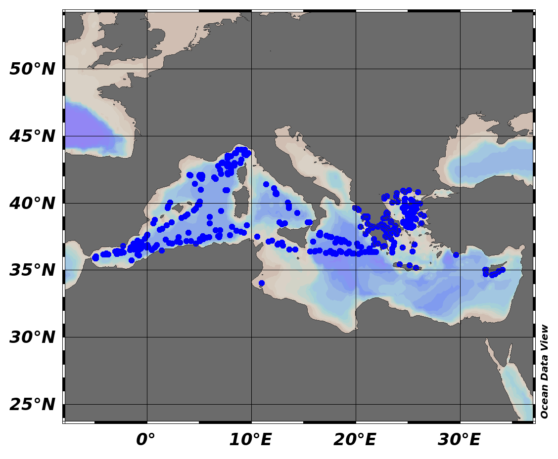
EMODnet Chemistry aims to provide access to marine chemistry data sets and derived data products concerning eutrophication, ocean acidification and contaminants. The chemicals chosen reflect importance to the Marine Strategy Framework Directive (MSFD). This regional aggregated dataset contains all unrestricted EMODnet Chemistry data on contaminants (24 parameters), and covers the Mediterranean Sea with 4517 CDI records divided per matrices: 520 biota profiles, 560 water profiles, 3437 sediment (26 Vertical profiles and 3411 Time series). In the water dataset, the vertical profiles temporal range is from 1974-09-12 to 2015-09-14. In sediment dataset, vertical profiles temporal range is from 2010-08-02 to 2014-09-28 and time series temporal range is from 1981-06-27 to 2018-08-02. In biota time series temporal range is from 1979-03-29 to 2017-03-15. Data were aggregated and quality controlled by ‘Hellenic Centre for Marine Research, Hellenic National Oceanographic Data Centre (HCMR/HNODC)’ from Greece. Regional datasets concerning contaminants are automatically harvested. Parameter names in these datasets are based on P01, BODC Parameter Usage Vocabulary, which is available at: http://seadatanet.maris2.nl/bandit/browse_step.php . Each measurement value has a quality flag indicator. The resulting data collections for each Sea Basin are harmonised, and the collections are quality controlled by EMODnet Chemistry Regional Leaders using ODV Software and following a common methodology for all Sea Regions. Harmonisation means that: (1) unit conversion is carried out to express contaminant concentrations with a limited set of measurement units (according to EU directives 2013/39/UE; Comm. Dec. EU 2017/848) and (2) merging of variables described by different “local names” ,but corresponding exactly to the same concepts in BODC P01 vocabulary. The harmonised dataset can be downloaded as ODV spreadsheet (TXT file), which is composed of metadata header followed by tab separated values. This worksheet can be imported to ODV Software for visualisation (More information can be found at: https://www.seadatanet.org/Software/ODV ). The same dataset is offered also as XLSX file in a long/vertical format, in which each P01 measurement is a record line. Additionally, there are a series of columns that split P01 terms in subcomponents (measure, substance, CAS number, matrix...).This transposed format is more adapted to worksheet applications users (e.g. LibreOffice Calc). The 24 parameter names in this metadata record are based on P02, SeaDataNet Parameter Discovery Vocabulary, which is available at: http://seadatanet.maris2.nl/v_bodc_vocab_v2/vocab_relations.asp?lib=P02 . Detailed documentation will be published soon. The original datasets can be searched and downloaded from EMODnet Chemistry Download Service: https://emodnet-chemistry.maris.nl/search
-
The survey was conducted at 17 stations in the coastal waters of the Maltese Islands in 2012. Sediment samples were collected using a Van Veen grab sampler. The collected sediment was collected in a container of adequate size, photographed and immediately sampled. At each station two samples were collected in order to execute and compare two chemical analyses. These were placed in a cool box and transported to the warehouse and stored in a refrigerator. Later, they were shipped by express courier to the laboratory within 3 working days. The samples were analysed for the level of pollutants using International Organization for Standardization and US Environmental Protection Agency standard procedures. The pollutants tested for are important metals, hydrocarbons and PAHs and persistent organic compounds that can cause bioaccumulation. The measurements were made in connection with a monitoring survey of Maltese coastal waters. The resultant datasets generated provide the benchmark for long term monitoring programs and assessments that are required in order to implement EU Directives on water resources.
-
The Mediterranean Sea (MS) is a large oligotrophic sea. Its productivity may be sensitive to riverine nutrient inputs. Understanding its productivity involves quantifying phosphorus (P) river supply which is crucial for calculating P mass balances in the anthropogenically disturbed sea. Yet the precise role of the deltaic filter is not known, especially concerning the differential trapping/recycling of nutrients in deltaic sediments. A benthic dataset from the Rhône River prodelta was coupled to an early diagenetic model, including the benthic P cycle. The dataset comprised porewater oxygen, nitrate, sulfate, dissolved inorganic carbon, ammonium, dissolved reduced and total iron, dissolved inorganic phosphorus (DIP) and solid data (organic carbon, Fe-bound P, Ca-bound P and organic P) for 9 stations from the Rhône River prodelta. The model results indicated that the intensity of biogeochemical processes occurring near the sediment–water interface decreased from the river mouth to the adjacent continental shelf. This decrease occurred according to OC fluxes to the seafloor, sedimentation rates and integrated rates of OC mineralization (from 160 mmol C m-2 d-1 near the mouth to 10 mmol m-2 d-1 on the shelf). The organic P mineralization was intense, especially near the river mouth (1196 µmol m-2 d-1), and its contribution to DIP release was large (> 90%). Fe-bound P had a key role in promoting Ca-bound P precipitation in anoxic sediments. These sediments played an important role as a source of regenerated DIP.A significant part of DIP was recycled to the overlying waters (72-94%), representing 25% of the riverine discharge input of DIP. While 6-28% of produced DIP was buried as Ca-bound P, which represented 3-6% of the riverine inputs. Important Note: This submission has been initially submitted to SEA scieNtific Open data Edition (SEANOE) publication service and received the recorded DOI. The metadata elements have been further processed (refined) in EMODnet Ingestion Service in order to conform with the Data Submission Service specifications.
-
Heavy metal samples from soft sediments in Tallinn Bay, Muuga Bay and Ihasalu Bay 2012-2013.