 EMODnet Product Catalogue
2014
Type of resources
Available actions
Topics
Keywords
Contact for the resource
Provided by
Years
Formats
Representation types
Update frequencies
status
Scale 1:
Resolution
-
Benthos samples taken as part of the EIA of the harbour constructions at Rotterdam
-
Timeseries oceanographic data for the period Jan 2011 - Feb 2014
-
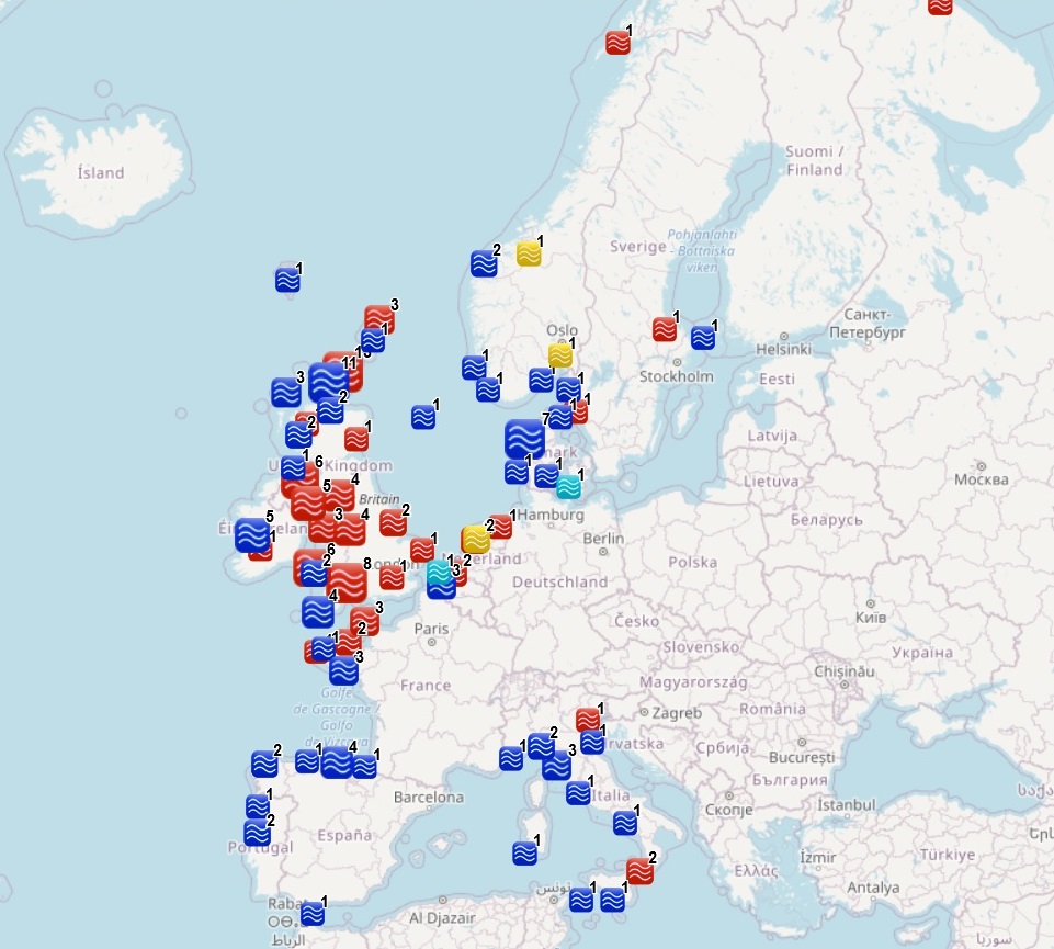
The dataset on ocean energy in the European seas was created in 2014 by AZTI for the European Marine Observation and Data Network (EMODnet). It is the result of the aggregation and harmonization of datasets provided by several sources from all across the European countries. It is updated every year, and is available for viewing and download on EMODnet web portal (Human Activities, https://emodnet.ec.europa.eu/en/human-activities). The dataset contains points representing Ocean Energy project sites in the following countries: Belgium, Denmark, Finland, France, Ireland, Italy, Norway, Portugal, Russia, Spain, Sweden, The Netherlands and United Kingdom. Where available, each point has the following attributes: site code (ID_1), project code (ID), name, location, country, sea basin, sea, distance to coast (metres), resource type (wave, tidal, salinity gradient, wave/wind), starting year, ending year, lease status, technology (Based on www.aquaret.com/), device, device scale (Full scale, prototype, etc.), project scale (Commercial, Demonstrator Array, etc.), project status (operational, completed, etc.), project capacity (KW), promoter, position info (it indicates if the attribute value is original from the source or has been estimated or calculated the polygon centroid) and the studies conducted for the environmental assessment (EIA). In 2016, a feature on areas for ocean energy test sites was included. It contains polygons representing Ocean Energy test sites in the following countries: Denmark, France, Ireland, Norway, Portugal, Spain, Sweden, The Netherlands and United Kingdom. Where available, each polygon has the following attributes: test site code, name, location, country, sea basin, sea, distance to coast (metres), resource type (wave, tidal), starting year, ending year, lease status, site status, capacity (kW), depth (metres), area (square km), grid connection, number of berths, developer, position info (it indicates if the attribute value is original from the source or has been estimated) and the studies conducted for the Environmental Assessment (EIA). In 2024, new data has been included and existing data has been updated.
-
The Wild Atlantic Way Route is a long distance touring route along the West Coast of Ireland, stretching from Donegal to Cork. This dataset is a set of locations along the Wild Atlantic Way that are points of interest which a tourist or member of the public maybe interested in stopping at. These are a subset of the Discovery points dataset, they represent 15 of discovery points dataset that have been designated as “Signature Points”. These places are especially unique and shape the image of Ireland’s remarkable west coast.
-
This dataset shows the distribution of fishing effort by fishing vessels according to the gear type used. Fishing effort is defined as the time spent engaged in fishing operations or time spent at sea, this time may be multiplied by a measure of fishing capacity, e.g. engine power. In this dataset fishing effort is measured as average hours spent actively fishing per kilometre square, per year. Data from years 2014 to 2018 was used to produce this data product for the Marine Institute publication the “Atlas of Commercial Fisheries around Ireland, third edition“ (https://oar.marine.ie/handle/10793/1432).
-
Coastal sea levels have been monitored for decades by networks of tide gauges in Bulgarian ports and harbors, established by a diverse range of organizations to fulfill their specific needs and requirements.Now the sea level stations are equipped with radar sensors.
-
COALA (COAstal LAgoon, Ref. PTDC/MAR/114217/2009) project aimed to contribute to study the nutrients and particulate matter dynamics - exchanges between Ria Formosa, south of Portugal, and the adjacent ocean through a multiple inlet system. As part of this project, two pressure sensors were placed in Ria Formosa to acquire sea level and temperature data, one in Faro-Olhão inlet and another 6 km upstream, in the Faro commercial pier, in addition to seventeen semi-diurnal tidal experimental campaigns carried out in the three inlets of the western sector of Ria Formosa. Important Note: This submission has been initially submitted to SEA scieNtific Open data Edition (SEANOE) publication service and received the recorded DOI. The metadata elements have been further processed (refined) in EMODnet Ingestion Service in order to conform with the Data Submission Service specifications.
-
Aimed at understanding the mesoscale eddy’s effect on the subduction and dissipation of the North Pacific Subtropical Mode Water, a field experiment namely the Pacific Mode Water Ventilation Experiment (P-MoVE) was carried out in the northwestern Pacific Ocean ((Xu et al., 2016)-[https://doi.org/10.1038/ncomms10505]). During 27 March to 5 April 2014, we conducted 54 station surveys in an anticyclonic eddy (AE) and a nearby weak cyclonic eddy (CE) with a spacing of 0.25° (Figure 1). The conductivity-temperature-depth system (CTD 911plus, Sea-Bird Electronics) and microstructure probe (MSS-90, Sea & Sun Technology) were deployed to obtain temperature-salinity profiles and microscale velocity shear at these stations. Important Note: This submission has been initially submitted to SEA scieNtific Open data Edition (SEANOE) publication service and received the recorded DOI. The metadata elements have been further processed (refined) in EMODnet Ingestion Service in order to conform with the Data Submission Service specifications.
-
This dataset shows the distribution of fishing effort by fishing vessels according to the gear type used. Fishing effort is defined as the time spent engaged in fishing operations or time spent at sea, this time may be multiplied by a measure of fishing capacity, e.g. engine power. In this dataset fishing effort is measured as average hours spent actively fishing per kilometre square, per year. Data from years 2014 to 2018 was used to produce this data product for the Marine Institute publication the “Atlas of Commercial Fisheries around Ireland, third edition“ (https://oar.marine.ie/handle/10793/1432).
-
Data indicates the location for mid-water trawl fishing activity in Irish waters. Attributes when known include year, area, gear type, species, season, days per year (Days_Year), number of vessels (Vessels), vessel size (LOA_Max), gear units, classification, Area of polygon (Area_M2), and data type.