 EMODnet Product Catalogue
features
Type of resources
Available actions
Topics
Keywords
Contact for the resource
Provided by
Years
status
-

-
-
-

-

-
Geophysics that are shown as polygons. Sometimes the real position of geophysical lines cannot be shown because of confidentiality reasons and in this case a polygon that shows the approximate location is used instead. In other cases the geophysics is best represented by a polygon – for example for 3D seismic surveys.
-

This data set is a compilation of all known marine geophysical survey lines. From this index, you can get an overview on available geological knowledge for European seas together with contact information for further details.
-
This data set is a compilation of all known marine points with geological knowledge. From this index, you can get an overview on available geological knowledge for European seas together with contact information for further details.
-

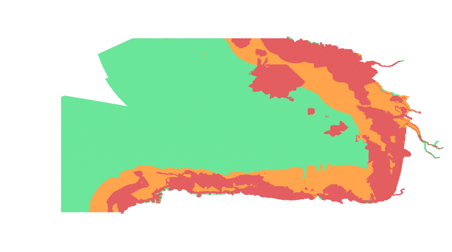
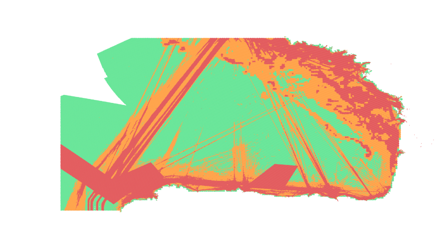
Seabed substrate map of the European marine areas (e.g. the Baltic Sea, the Greater North Sea, the Celtic Sea, the Iberian Coast, and the Mediterranean Sea within EU waters). The map is collated and harmonized from seabed substrate information within the EMODnet Geology project. Where necessary, the existing seabed substrate classifications (of individual maps) have been translated to a scheme that is supported by EUNIS. This EMODnet reclassification scheme includes at least five seabed substrate classes. Four substrate classes are defined on the basis of the modified Folk triangle (mud to sandy mud; sand; coarse sediment; and mixed sediment) and one additional substrate class (rock and boulders) was included by the project team. If the original seabed substrate dataset has enabled more detailed substrate classification, classifications with 7 and 16 substrate classes might be available. The EMODnet-Geology project started in 2013 with 36 marine departments of the geological surveys of Europe, with an objective to assemble marine geological information from all European sea areas. Note: The data may include some errors e.g. data discontinuities.
-

Seabed substrate map of the European marine areas (e.g. the Baltic Sea, the Greater North Sea, the Celtic Sea, the Iberian Coast, and the Mediterranean Sea within EU waters). The map is collated and harmonized from seabed substrate information within the EMODnet Geology project. Where necessary, the existing seabed substrate classifications (of individual maps) have been translated to a scheme that is supported by EUNIS. This EMODnet reclassification scheme includes at least five seabed substrate classes. Four substrate classes are defined on the basis of the modified Folk triangle (mud to sandy mud; sand; coarse sediment; and mixed sediment) and one additional substrate class (rock and boulders) was included by the project team. If the original seabed substrate dataset has enabled more detailed substrate classification, classifications with 7 and 16 substrate classes might be available. The EMODnet-Geology project started in 2013 with 36 marine departments of the geological surveys of Europe, with an objective to assemble marine geological information from all European sea areas. Note: The data may include some errors e.g. data discontinuities.