 EMODnet Product Catalogue
Habitats and biotopes, Hábitats y biotopos, Protected sites, Lugares protegidos, Species distribution, Distribución de las especies, Rasgos oceanográficos, Hidrografía, Geology, Geología, Biology, Biología
Type of resources
Available actions
Topics
Keywords
Contact for the resource
Provided by
Years
Formats
Representation types
Update frequencies
status
Scale 1:
-
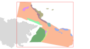
This dataset contains the habitats map from the SCI (Site of Community Importance) ÔÇ£Sistema de Ca├▒ones Submarinos Occidentales del Golfo de Le├│nÔÇØ. The marine area ÔÇ£South-West Gulf of Lions canyons systemÔÇØ is located in the northeastern part of the Iberian Peninsula. The coastline belongs to the Catalan province of Girona, featuring a large number of rocky outcrops with many coves, small beaches, vertical cliffs and islets. Cape Creus is the most notorious element of the landscape, which corresponds to the easternmost part of the Pyrenees Mountains. This small peninsula is characterized by its wildness, and despite its low relief it penetrates into the Mediterranean Sea for more than 10 kilometers.This study was supported by the INDEMARES-LIFE+ Project, EC contract INDEMARES-LIFE+ (07/NAT/E/000732): Inventory and Designation of the Natura 2000 network in marine areas of the Spanish State (www.indemares.es/en). This work was coordinated by the Biodiversity Foundation (www.fundacion-biodiversidad.es). Habitats are classified according to EUNIS nomenclature and the List of Marine Habitats in Spain (LPRE, that itÔÇÖs classified hierarchically and was completed and published in March 2013). Habitats classification are been simplified owing to the requirements of the EMODnet (European Marine Observation and Data Network) portal for Seabed Habitats.
-
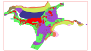
This dataset contains the habitats map from the SCI (Site of Community Importance) ÔÇ£Canal de MenorcaÔÇØ. The "Menorca Channel" is a marine corridor located between the islands of Mallorca and Menorca in the Balearic Islands archipelago, with a minimum distance between the two islands of 36 kilometers. Its geographical position in the centre of the Western Mediterranean and its location, between islands, gives the area a peculiar set of oceanographic characteristics, including strong currentsand unusually transparent waters. This study was supported by the INDEMARES-LIFE+ Project, EC contract INDEMARES-LIFE+ (07/NAT/E/000732): Inventory and Designation of the Natura 2000 network in marine areas of the Spanish State (www.indemares.es/en). This work was coordinated by the Biodiversity Foundation (www.fundacion-biodiversidad.es). Habitats are classified according to EUNIS nomenclature and the List of Marine Habitats in Spain (LPRE, that itÔÇÖs classified hierarchically and was completed and published in March 2013). Habitats classification are been simplified owing to the requirements of the EMODnet (European Marine Observation and Data Network ) portal for Seabed Habitats.