 EMODnet Product Catalogue
Habitat
Type of resources
Available actions
Topics
Keywords
Contact for the resource
Provided by
Years
Formats
Representation types
Update frequencies
status
Scale 1:
-
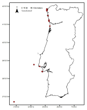
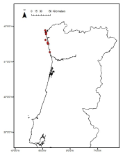
Laminaria ochroleuca distribution in the Portuguese mainland from historical data. Data provided by the Project FindKelp and published in: ÔÇ£Findkelp, a GIS-based Community Participation Project to Assess Portuguese Kelp Conservation StatusÔÇØ. Journal of Coastal Research (2009) :SI 56 (1469-1473)
-
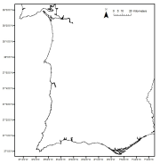
Saccorhiza polyschides distribution in the Portuguese mainland from historical data. Data provided by the Project FindKelp and published in: ÔÇ£Findkelp, a GIS-based Community Participation Project to Assess Portuguese Kelp Conservation StatusÔÇØ. Journal of Coastal Research (2009) :SI 56 (1469-1473)
-
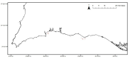
Maerl beds distribution in the Portuguese mainland from historical data. Data published in: ÔÇ£Present distribution of maerl beds in the Atlantic Iberian PeninsulaÔÇØ. Museologia Scientifica e Naturalista. Volume Speciale 2009
-
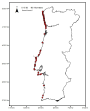
Zostera noltii meadows distribution in the Portuguese mainland from historical data. Data provided by the Life Project BIOMARES and published in: ÔÇ£Seagrasses in Portugal: A most endangered marine habitatÔÇØ. Aquatic Botany. doi:10.1016/j.aquabot.2011.08.007. ÔÇ£Estimation of available seagrass meadows area in Portugal for transplanting purposes ÔÇØ. Journal of Coastal Research (2009) :SI 56 (1100-1104)
-
Cymodocea nodosa meadows distribution in the south of Portugal from historical data. Data provided by the Life Project BIOMARES and published in: ÔÇ£Seagrasses in Portugal: A most endangered marine habitatÔÇØ. Aquatic Botany. doi:10.1016/j.aquabot.2011.08.007. ÔÇ£Estimation of available seagrass meadows area in Portugal for transplanting purposes ÔÇØ. Journal of Coastal Research (2009) :SI 56 (1100-1104)
-
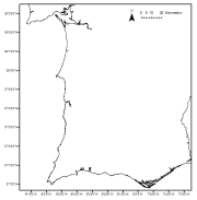
Laminaria hyperborea distribution in the Portuguese mainland from historical data. Data provided by the Project FindKelp and published in: ÔÇ£Findkelp, a GIS-based Community Participation Project to Assess Portuguese Kelp Conservation StatusÔÇØ. Journal of Coastal Research (2009) :SI 56 (1469-1473)
-
Zostera marina meadows distribution in the Portuguese mainland from historical data. Data provided by the Life Project BIOMARES and published in: ÔÇ£Seagrasses in Portugal: A most endangered marine habitatÔÇØ. Aquatic Botany. doi:10.1016/j.aquabot.2011.08.007. ÔÇ£Estimation of available seagrass meadows area in Portugal for transplanting purposes ÔÇØ. Journal of Coastal Research (2009) :SI 56 (1100-1104)
-
The measurements of Secchi depth were done within Estonia-Latvia transboundary project "Towards joint management of the transboundary Gauja/Koiva river basin district" for harmonization of water quality classification system for transboundary water bodies in the Gauja/Koiva river basin district and adjacent areas (in Estonia) in the Gulf of Riga." The measurements were done once in August 2012 along with underwater video observation, SPM, TN, TC, Chlorophyll a and CTD measurements in coastal waters in shallow part (2 - 12m) of the East coast of the Gulf of Riga. Data were used for Final report on assessment of the quality status of the transboundary water bodies (coastal, lakes, rivers) in Gauja/Koiva river basin district (2013. Kalvane I. and Veidemane K. (eds.))
-
A geotechnical survey campaign was undertaken within the vicinity of the Westermost Rough Offshore Wind Farm. This was supported by a preliminary review of acoustic data and assessment for the presence of Annex I reefs to minimise the risk of potential damage to protected features. Following the review of existing data, a drop down video survey protocol was developed (EMU, 2011) and approved by the Marine Management Organisation (MMO). Part of this protocol identified that a number of proposed geotechnical sampling sites were likely to be in the vicinity of potential Annex I reefs and therefore warranted field ground-truthing by means of drop down video to verify the presence and status of these features. The video ground-truthing survey has now been completed. Drawing upon the findings of this survey, the 2012 EMU report present within this series provides an update of the assessment of the potential Annex I reefs present at the proposed geotechnical sample locations and fulfils condition 3.1.1 of the Marine Licence (Licence L/2011/001075). The aim of the 2013 Fugro EMU document also present within this series was to satisfy Marine Licence condition 31.22 and to address the responses from the MMO regarding the Annex I reef features (letter ref: REN024, dated 12th April 2013, and 21st June 2013). The objectives were to assess the impacts (direct and indirect) of the construction activities on the potential Annex I features. The objectives of this report were to: 1. Assess the direct impact (loss of habitat) of each of the construction activities; 2. Assess the associated indirect impacts (increase in sediment smothering, and suspended sediment concentrations. 3. Assess the cumulative impacts of all construction activities.
-
Classification of the Atlantic Ocean seabed into broad-scale benthic habitats employing a hierarchical top-down clustering approach aimed at informing Marine Spatial Planning. This work was performed at the University of Plymouth in 2021 with data provided by a wide group of partners representing the nations surrounding the Atlantic Ocean. It classifies continuous environmental data into discrete classes that can be compared to observed biogeographical patterns at various scales. It has 3 levels of classification. For ease of use, a layer is provided for each level. Level 1 has 4 classes. Level 2 has 15 classes nested within level 1. Layers indices are 2 digits (1[level1 class index]1[level 2 class index]). Level 3 has 157 classes nested within level 2 and class names have 4 digits (1digit[level1 class index]1[level 2 class index]2[level 3 class index]). Note that the classification was performed for the whole world and thus it has more classes than in the presented layer.