 EMODnet Product Catalogue
Carbon concentrations in sediment
Type of resources
Available actions
Topics
Keywords
Contact for the resource
Provided by
Years
Formats
Representation types
-
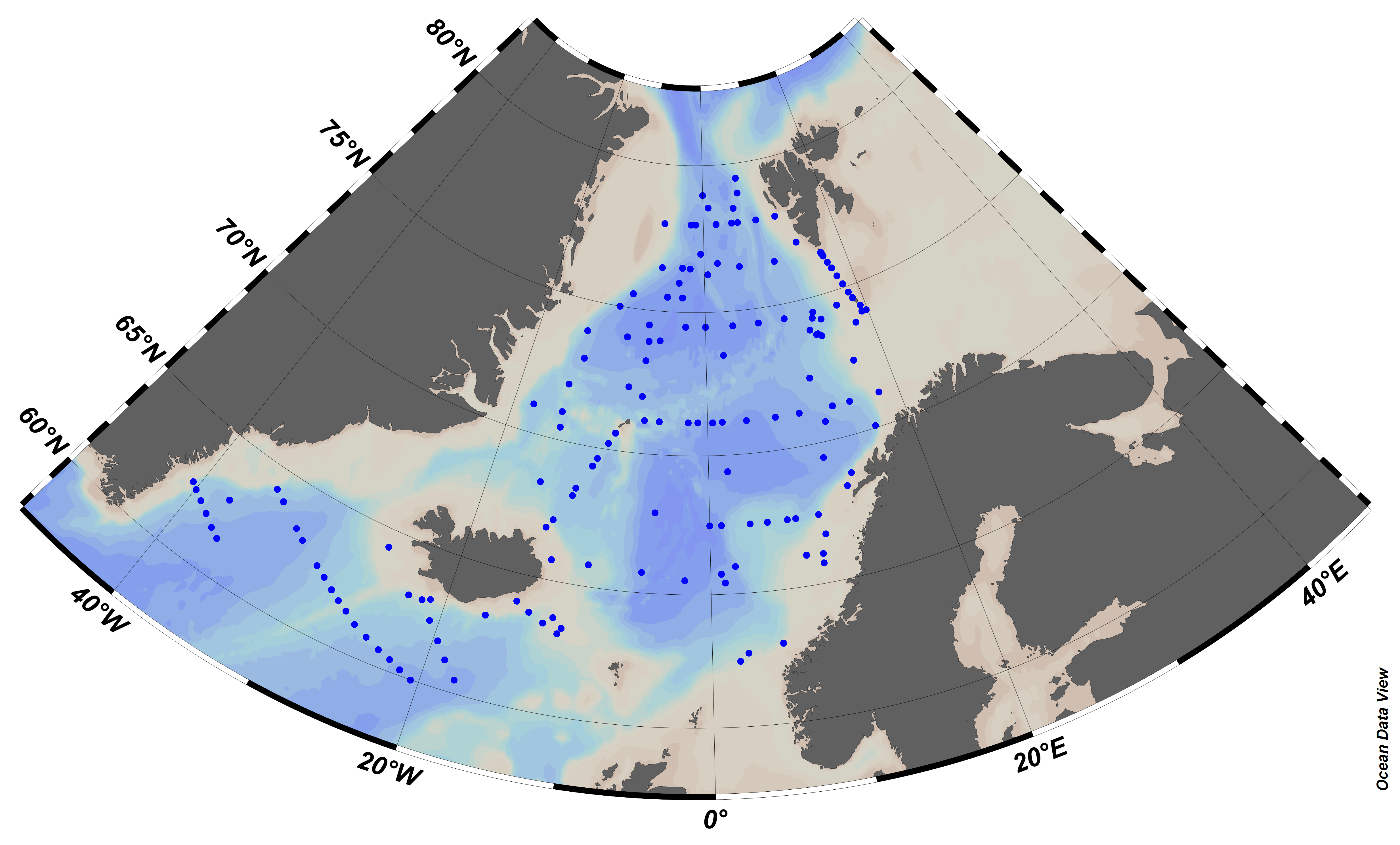
EMODnet Chemistry aims to provide access to marine chemistry data sets and derived data products concerning eutrophication, ocean acidification and contaminants. The chemicals chosen reflect importance to the Marine Strategy Framework Directive (MSFD). This regional aggregated dataset contains all unrestricted EMODnet Chemistry data on contaminants (20 parameters), and covers the Arctic Ocean with 548 CDI records divided per matrices: 235 water profiles, 313 sediment profiles. Vertical profiles temporal range is from 1974-03-25 to 2015-06-15. Data were aggregated and quality controlled by ‘Institute of Marine Research - Norwegian Marine Data Centre (NMD)’ from Norway. Regional datasets concerning contaminants are automatically harvested. Parameter names in these datasets are based on P01, BODC Parameter Usage Vocabulary, which is available at: http://seadatanet.maris2.nl/bandit/browse_step.php . Each measurement value has a quality flag indicator. The resulting data collections for each Sea Basin are harmonised, and the collections are quality controlled by EMODnet Chemistry Regional Leaders using ODV Software and following a common methodology for all Sea Regions. Harmonisation means that: (1) unit conversion is carried out to express contaminant concentrations with a limited set of measurement units (according to EU directives 2013/39/UE; Comm. Dec. EU 2017/848) and (2) merging of variables described by different “local names” ,but corresponding exactly to the same concepts in BODC P01 vocabulary. The harmonised dataset can be downloaded as ODV spreadsheet (TXT file), which is composed of metadata header followed by tab separated values. This worksheet can be imported to ODV Software for visualisation (More information can be found at: https://www.seadatanet.org/Software/ODV ). The same dataset is offered also as XLSX file in a long/vertical format, in which each P01 measurement is a record line. Additionally, there are a series of columns that split P01 terms in subcomponents (measure, substance, CAS number, matrix...).This transposed format is more adapted to worksheet applications users (e.g. LibreOffice Calc). The 20 parameter names in this metadata record are based on P02, SeaDataNet Parameter Discovery Vocabulary, which is available at: http://seadatanet.maris2.nl/v_bodc_vocab_v2/vocab_relations.asp?lib=P02 . Detailed documentation will be published soon. The original datasets can be searched and downloaded from EMODnet Chemistry Download Service: https://emodnet-chemistry.maris.nl/search
-

EMODnet Chemistry aims to provide access to marine chemistry data sets and derived data products concerning eutrophication, ocean acidification and contaminants. The chemicals chosen reflect importance to the Marine Strategy Framework Directive (MSFD). This regional aggregated dataset contains all unrestricted EMODnet Chemistry data on contaminants (49 parameters), and covers the Baltic Sea with 3818 CDI records divided per matrices: 1358 biota (396 Vertical profiles and 962 Time series),906 water profiles, 2510 sediment profiles. Vertical profiles temporal range is from 1985-04-16 to 2016-09-27. Time series temporal range is from 1972-05-02 to 2017-10-30. Data were aggregated and quality controlled by ‘Swedish Meteorological and Hydrological Institute (SMHI)’ from Sweden. Regional datasets concerning contaminants are automatically harvested. Parameter names in these datasets are based on P01, BODC Parameter Usage Vocabulary, which is available at: http://seadatanet.maris2.nl/bandit/browse_step.php . Each measurement value has a quality flag indicator. The resulting data collections for each Sea Basin are harmonised, and the collections are quality controlled by EMODnet Chemistry Regional Leaders using ODV Software and following a common methodology for all Sea Regions. Harmonisation means that: (1) unit conversion is carried out to express contaminant concentrations with a limited set of measurement units (according to EU directives 2013/39/UE; Comm. Dec. EU 2017/848) and (2) merging of variables described by different “local names” ,but corresponding exactly to the same concepts in BODC P01 vocabulary. The harmonised dataset can be downloaded as ODV spreadsheet (TXT file), which is composed of metadata header followed by tab separated values. This worksheet can be imported to ODV Software for visualisation (More information can be found at: https://www.seadatanet.org/Software/ODV ). The same dataset is offered also as XLSX file in a long/vertical format, in which each P01 measurement is a record line. Additionally, there are a series of columns that split P01 terms in subcomponents (measure, substance, CAS number, matrix...).This transposed format is more adapted to worksheet applications users (e.g. LibreOffice Calc). The 49 parameter names in this metadata record are based on P02, SeaDataNet Parameter Discovery Vocabulary, which is available at: http://seadatanet.maris2.nl/v_bodc_vocab_v2/vocab_relations.asp?lib=P02 . Detailed documentation will be published soon. The original datasets can be searched and downloaded from EMODnet Chemistry Download Service: https://emodnet-chemistry.maris.nl/search
-
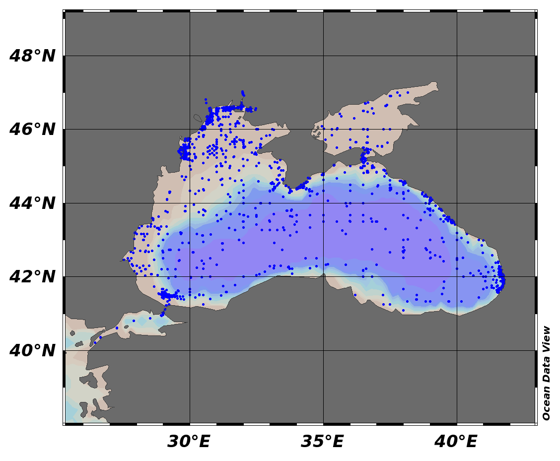
EMODnet Chemistry aims to provide access to marine chemistry data sets and derived data products concerning eutrophication, ocean acidification and contaminants. The chemicals chosen reflect importance to the Marine Strategy Framework Directive (MSFD). This regional aggregated dataset contains all unrestricted EMODnet Chemistry data on contaminants (48 parameters), and covers the Black Sea with 21504 CDI records divided per matrices: 7 biota profiles, 19677 water profiles, 1820 sediment profiles. Vertical profiles temporal range is from 1974-08-24 to 2017-10-06. Data were aggregated and quality controlled by ‘National Institute for Marine Research and Development "Grigore Antipa"’ from Romania. Regional datasets concerning contaminants are automatically harvested. Parameter names in these datasets are based on P01, BODC Parameter Usage Vocabulary, which is available at: http://seadatanet.maris2.nl/bandit/browse_step.php . Each measurement value has a quality flag indicator. The resulting data collections for each Sea Basin are harmonised, and the collections are quality controlled by EMODnet Chemistry Regional Leaders using ODV Software and following a common methodology for all Sea Regions. Harmonisation means that: (1) unit conversion is carried out to express contaminant concentrations with a limited set of measurement units (according to EU directives 2013/39/UE; Comm. Dec. EU 2017/848) and (2) merging of variables described by different “local names”, but corresponding exactly to the same concepts in BODC P01 vocabulary. The harmonised dataset can be downloaded as ODV spreadsheet (TXT file), which is composed of metadata header followed by tab separated values. This worksheet can be imported to ODV Software for visualisation (More information can be found at: https://www.seadatanet.org/Software/ODV ). The same dataset is offered also as XLSX file in a long/vertical format, in which each P01 measurement is a record line. Additionally, there are a series of columns that split P01 terms in subcomponents (measure, substance, CAS number, matrix...).This transposed format is more adapted to worksheet applications users (e.g. LibreOffice Calc). The 48 parameter names in this metadata record are based on P02, SeaDataNet Parameter Discovery Vocabulary, which is available at: http://seadatanet.maris2.nl/v_bodc_vocab_v2/vocab_relations.asp?lib=P02 . Detailed documentation will be published soon. The original datasets can be searched and downloaded from EMODnet Chemistry Download Service: https://emodnet-chemistry.maris.nl/search
-

EMODnet Chemistry aims to provide access to marine chemistry data sets and derived data products concerning eutrophication, ocean acidification and contaminants. The chemicals chosen reflect importance to the Marine Strategy Framework Directive (MSFD). This regional aggregated dataset contains all unrestricted EMODnet Chemistry data on contaminants (59 parameters), and covers the North Sea with 34978 CDI records divided per matrices: 3909 biota time series, 28071 water profiles, 2998 sediment profiles. Vertical profiles temporal range is from 1970-02-17 to 2017-10-26. Time series temporal range is from 1979-02-26 to 2017-02-28. Data were aggregated and quality controlled by ‘Aarhus University, Department of Bioscience, Marine Ecology Roskilde from Denmark. Regional datasets concerning contaminants are automatically harvested. Parameter names in these datasets are based on P01, BODC Parameter Usage Vocabulary, which is available at: http://seadatanet.maris2.nl/bandit/browse_step.php . Each measurement value has a quality flag indicator. The resulting data collections for each Sea Basin are harmonised, and the collections are quality controlled by EMODnet Chemistry Regional Leaders using ODV Software and following a common methodology for all Sea Regions. Harmonisation means that: (1) unit conversion is carried out to express contaminant concentrations with a limited set of measurement units (according to EU directives 2013/39/UE; Comm. Dec. EU 2017/848) and (2) merging of variables described by different “local names” ,but corresponding exactly to the same concepts in BODC P01 vocabulary. The harmonised dataset can be downloaded as ODV spreadsheet (TXT file), which is composed of metadata header followed by tab separated values. This worksheet can be imported to ODV Software for visualisation (More information can be found at: https://www.seadatanet.org/Software/ODV ). The same dataset is offered also as XLSX file in a long/vertical format, in which each P01 measurement is a record line. Additionally, there are a series of columns that split P01 terms in subcomponents (measure, substance, CAS number, matrix...).This transposed format is more adapted to worksheet applications users (e.g. LibreOffice Calc). The 59 parameter names in this metadata record are based on P02, SeaDataNet Parameter Discovery Vocabulary, which is available at: http://seadatanet.maris2.nl/v_bodc_vocab_v2/vocab_relations.asp?lib=P02 . Detailed documentation will be published soon. The original datasets can be searched and downloaded from EMODnet Chemistry Download Service: https://emodnet-chemistry.maris.nl/search
-

EMODnet Chemistry aims to provide access to marine chemistry data sets and derived data products concerning eutrophication, ocean acidification and contaminants. The chemicals chosen reflect importance to the Marine Strategy Framework Directive (MSFD). This regional aggregated dataset contains all unrestricted EMODnet Chemistry data on contaminants (20 parameters), and covers the North East Atlantic Ocean with 2400 CDI records divided per matrices: 122 in biota (as time series), 1689 in water (as vertical profiles), 589 in sediment (478 Vertical profiles and 111 Time series). Vertical profiles temporal range is from 1970-07-29 to 2017-02-28. Time series temporal range is from 1979-02-28 to 2014-10-21. Data were aggregated and quality controlled by ‘IFREMER / IDM / SISMER - Scientific Information Systems for the SEA’ from France. Regional datasets concerning contaminants are automatically harvested. Parameter names in these datasets are based on P01, BODC Parameter Usage Vocabulary, which is available at: http://seadatanet.maris2.nl/bandit/browse_step.php . Each measurement value has a quality flag indicator. The resulting data collections for each Sea Basin are harmonised, and the collections are quality controlled by EMODnet Chemistry Regional Leaders using ODV Software and following a common methodology for all Sea Regions. Harmonisation means that: (1) unit conversion is carried out to express contaminant concentrations with a limited set of measurement units (according to EU directives 2013/39/UE; Comm. Dec. EU 2017/848) and (2) merging of variables described by different “local names” ,but corresponding exactly to the same concepts in BODC P01 vocabulary. The harmonised dataset can be downloaded as ODV spreadsheet (TXT file), which is composed of metadata header followed by tab separated values. This worksheet can be imported to ODV Software for visualisation (More information can be found at: https://www.seadatanet.org/Software/ODV ). The same dataset is offered also as XLSX file in a long/vertical format, in which each P01 measurement is a record line. Additionally, there are a series of columns that split P01 terms in subcomponents (measure, substance, CAS number, matrix...).This transposed format is more adapted to worksheet applications users (e.g. LibreOffice Calc). The 20 parameter names in this metadata record are based on P02, SeaDataNet Parameter Discovery Vocabulary, which is available at: http://seadatanet.maris2.nl/v_bodc_vocab_v2/vocab_relations.asp?lib=P02 . Detailed documentation will be published soon. The original datasets can be searched and downloaded from EMODnet Chemistry Download Service: https://emodnet-chemistry.maris.nl/search
-
Coastal marine sediments receive intensive stress from urbanization and industrialization, which is manifested by increased contents of heavy metals and organic pollutants. Saronikos Gulf and the small embayment of Elefsis, stretch along the coast of the greater Athens and Pireaus port, the most urbanized and industrialized areas in Greece. Here we present the data of a 20-years geochemical record on grain-size, organic carbon, and major and trace elements contents of the Saronikos Gulf sediments. A total of 216 sediment samples were collected within the period of 1999 to 2018 from the four sub-sectors of the gulf, namely, the Elefsis Bay, the Inner, Outer, and Western (Megara and Epidavros basin) Saronikos Gulf. Additionally, at least one core was obtained from each sub-sector. Sediments deposited at pre-industrial periods were recognized by 14C and 210Pb datings, and served for establishing regionalized, background levels of metals. Factor analysis was conducted to reveal the inter-parametric relationships, thus their common sources, as well as transport and deposition pathways. Then, Enrichment Factors and the multi-elemental Modified Pollution Index (MPI) were calculated to assess the current environmental status of the sediments. Data of sampling sites with at least a five-year record, were assessed for temporal trends, to explore whether sustained, increasing or decreasing trends of the MPI are observed. The dataset and analyses presented here support the research article entitled Geochemistry of major and trace elements in surface sediments of the Saronikos Gulf (Greece): assessment of contamination between 1999 and 2018 by Karageorgis A.P., Botsou F., Kaberi H., and Iliakis S., https://doi.org/10.1016/j.scitotenv.2020.137046
-
The purpose of this publication is to give access to the analytic data set which has been used in a paper submitted to the journal Marine Geology (Torelli et al., submitted). This paper proposes a general study of the organic matter (OM) distribution within the recent Quaternary sediments of the Mozambique Channel (southern part of the east African margins). The study was conducted in the framework of the PAMELA (PAssive Margin Exploration LAboratory) research project (Bourillet et al., 2013). This study is mainly based on Rock-Eval 6 (RE6) analyses of samples collected during several marine surveys: Pamela-Moz01 (Olu, 2014), Pamela-Moz04 (Jouet and Deville, 2015) and Pamela-Moz08 (Khripounoff, 2016; Fig. 1). 394 RE6 analyses were performed on samples collected with the Küllenberg corer (recovered core length up to 12 m) of the R/V Atalante (Pamela-Moz01 survey) and the Calypso corer (recovered core length up to 33 m) of the R/V Pourquoi Pas? (Pamela-Moz04 survey), 11 RE6 analyses on samples collected with an interface multicorer (30-40 cm maximum penetration), and 101 RE6 analyses on samples collected with sediment traps in moorings located 47 m above seabed. We provide here the whole RE6 analyses (Table 1) and the correlation made between RE6 analyses and LECO elemental analyses concerning the total carbon (Tables 2 and 3). The analysis of samples collected with particle traps within the deep-water areas of the Mozambique Basin has shown that the OM is transported by turbidite and/or contour currents and deposited while preserving Total Organic Carbon (TOC) contents between 1.5 and 3%Wt. However, the sedimentary OM is largely oxidized (Oxygen Index > 300 mg CO2/g TOC) and only a small amount of TOC (< 0.5%Wt) is preserved within the recent sediments of the distal area of the Zambezi turbidite system at water depths below 2500 m. Interface sediments sampled to a maximum depth of 40 cm, have shown intermediate TOC values between those collected in the particle traps and those from piston cores suggesting that the degradation of the OM is mainly active at the water-sediment interface. This OM oxidation and degradation process in the deep-water domains of the Mozambique Basin is probably due to the conjugate effects of low sediment accumulation rate and high permeability of the coarse-grained sediments but also to important bottom currents that promote the remobilization and the rearrangement of fine grained sediments. References Bourillet, J.F., Ferry, J.N., Bourges, P., 2013. PAMELA, Passive Margins Exploration Laboratories. https://dx.doi.org/10.18142/236. Jouet, G., Deville, E., 2015. PAMELA-MOZ04 cruise, R/V Pourquoi Pas? https://doi.org/10.17600/15000700. Khripounoff, A., 2017. PAMELA-MOZ08 cruise, R/V Antea. https://doi.org/10.17600/17003900. Olu, K, 2014. PAMELA-MOZ01 cruise, R/V L'Atalante, https://dx.doi.org/10.17600/14001000. Torelli, M., Battani, A., Pillot, D., Kohler, E., Lopes De Azevedo, J., Kowalewski, I., Pastor, L., Brandily, C., Schmidt, S., Jouet, G., Deville, E. (Submitted to Marine Geology). Organic matter distribution in modern sediments of the Mozambique Channel: Evidence for widespread oxidation processes in the deep-water domains. Important Note: This submission has been initially submitted to SEA scieNtific Open data Edition (SEANOE) publication service and received the recorded DOI. The metadata elements have been further processed (refined) in EMODnet Ingestion Service in order to conform with the Data Submission Service specifications.
-
Pialassa Baiona is a temperate coastal lagoon connected with the Northwestern Adriatic Sea (44° 280 N and 44°310 E). Sediment cores and surface sediments were collected in two habitats within Pialassa Baiona: a) a salt marsh habitat characterized by the presence of saltmarsh vegetation, and b) a human impacted habitat close to anthropogenic source inputs. Cores were sampled by inserting one cylindrical Plexiglas hand corer (5-cm diameter, 50 cm long) into the sediment to a depth of 20-25 cm, and surface sediment samples (0–5 cm) were collected with a stainless-steel grab sampler. The cores were extruded in the field, sectioned into 1-2 cm intervals, and analyzed for total organic carbon (OC), total nitrogen (TN), carbon isotope ratio (d13C) and dry bulk density (upper 20 – 25 cm) and analyzed for organic carbon (OC), total nitrogen (TN), carbon isotope ratio (d13C) and dry bulk density. Organic carbon (OC), total nitrogen (TN), and carbon isotopes (d13C = [(13C/12C)sample/(13C/12C)standard - 1] × 1,000) were measured in sediment cores and surface sediments using a using a FINNIGAN Delta Plus XP mass spectrometer directly coupled to Thermo Fisher FLASH 2000 CHNS Elemental Analyzer. OC and TN content was expressed as the weight percentage of dried sediment, and carbon isotope results were reported in the standard delta notation with respect to the Vienna Pee Dee Belemnite. A ‘three-end member’ mixing model was used to estimate the relative contribution of the different organic matter (OM) sources: marine phytoplankton (FM), riverine-estuarine phytoplankton (FRE), and C3 saltmarsh plant material (FSM): d13Csample = d13CM x FM + d13CFE x FFE + d13CSM x FSM C/Nsample = C/NM x FM + C/NFE x FFE + C/NSM x FSM 1 = FM + FRE + FSM where FM, FRE and FSM are the relative contributions of marine phytoplankton, riverine-estuarine phytoplankton, and saltmarsh plant material, respectively. d13CM (-18.97‰) and C/NM (4.95), and d13CRE (-30.70‰,) and C/NRE (6.63) represent the end member POC signature recorded during distinct marine and estuarine phytoplankton blooms in the coastal lagoon (Guerra et al., 2013).The C3 saltmarsh plant end-member was selected on the basis of typical d13CSM (-20.2‰) and C/NSM (15.35) values for Juncus spp. (Gebrehiwet et al., 2008; Hughes and Sherr, 1983; J. I. Kelleway et al., 2017; Kemp et al., 2012, 2010; Lamb et al., 2006). References Gebrehiwet, T., Koretsky, C.M., Krishnamurthy, R. V., 2008. Influence of Spartina and Juncus on saltmarsh sediments. III. Organic geochemistry. Chem. Geol. 255, 114–119. https://doi.org/10.1016/j.chemgeo.2008.06.015 Guerra, R., Pistocchi, R., Vanucci, S., 2013. Dynamics and sources of organic carbon in suspended particulate matter and sediments in Pialassa Baiona lagoon (NW Adriatic Sea, Italy). Estuar. Coast. Shelf Sci. 135, 24–32. https://doi.org/10.1016/j.ecss.2013.06.022 Kelleway, J.I., Saintilan, N., Macreadie, P.I., Baldock, J.A., Ralph, P.J., 2017. Sediment and carbon deposition vary among vegetation assemblages in a coastal salt marsh. Biogeosciences 14, 3763–3779. https://doi.org/10.5194/bg-14-3763-2017 Kemp, A.C., Vane, C.H., Horton, B.P., Culver, S.J., 2010. Stable carbon isotopes as potential sea-level indicators in salt marshes, North Carolina, USA. Holocene 20, 623–636. https://doi.org/10.1177/0959683609354302 Kemp, A.C., Vane, C.H., Horton, B.P., Engelhart, S.E., Nikitina, D., 2012. Application of stable carbon isotopes for reconstructing salt-marsh floral zones and relative sea level, New Jersey, USA. J. Quat. Sci. 27, 404–414. https://doi.org/10.1002/jqs.1561 Important Note: This submission has been initially submitted to SEA scieNtific Open data Edition (SEANOE) publication service and received the recorded DOI. The metadata elements have been further processed (refined) in EMODnet Ingestion Service in order to conform with the Data Submission Service specifications.
-
The Sediments Baseline Survey was conducted in 10 inland water bodies. The samples were collected between 29th May and 6th June 2013. Two replicate samples of superficial (up to 10 cm depth) sediments were collected from each station using pre-treated samplers. Where water was sufficiently shallow, sediments were collected by hand using a core sampler, while in locations where water bodies were deep, sediment was collected using a hand-held stainless steel grab. The pollutants tested for include the list of priority substances and other pollutants as stipulated in the Environmental Quality Standard Directive (2008/105/EC). Chemical analyses of sediment samples for all parameters analysed were carried out according to standard methodology at CADA Laboratories s.n.c. (Italy), which are accredited according to ACCREDIA 2 CEN/ISO 17025 certification.