 EMODnet Product Catalogue
2019
Type of resources
Available actions
Topics
Keywords
Contact for the resource
Provided by
Years
Formats
Representation types
status
Scale 1:
Resolution
-
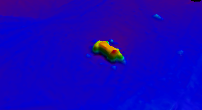
BalticSea_Maritime_Administration_Latvia Wreck found using MBES technique
-
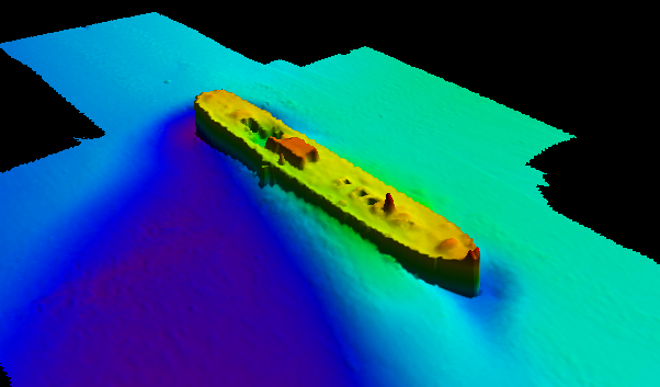
BalticSea_Maritime_Administration_Latvia Wreck found using MBES technique
-
This set of CTD measurements places the fresh water discharge into the sea, which is located in Punta Esmeralda in the City of Playa del Carmen, State of Quintana Roo, in the Mexican Caribbean Sea. For these measurements two measuring instruments were used; a CTD for temperature and salinity profiles and a USGS type AA current meter to measure discharge to the sea, applying two methodologies for the measurement of volumetric flow according to FAO, (2009). Punta Esmeralda is a beach site that has three springs on the beach which form a freshwater lagoon about 60 meters long by 25 wide and a deep part of 1.6 meters. This lagoon is located at the coordinates 20.648372 ° N 87.050909 ° W. The discharge of water forms a small stream with a stream 6 meters wide with a bathymetric profile with a maximum depth of 0.40 m. These dimensions change over time due to natural and artificial processes. The fresh water discharge to the sea has an average flow of 0.2142 m3 /s , at an average speed of 0.1305 m /s. The sampling points with the CTD were a total of 61 and were distributed throughout the lagoon, the output of the three largest springs and a small "cenote" that is located about 76 meters away from the beach, were also performed sampling points in the sea at a distance of 100 meters from the coast and 2 meters deep. The salinity ranges measured in the springs was 4 UPS and it was increasing to the sea with 35 UPS. With temperatures in the springs from 25.8 ° C to 30.8 ° C in the sea. Important Note: This submission has been initially submitted to SEA scieNtific Open data Edition (SEANOE) publication service and received the recorded DOI. The metadata elements have been further processed (refined) in EMODnet Ingestion Service in order to conform with the Data Submission Service specifications.
-
This dataset contains turbidity (NTU) data acquired between August 2018 and June 2019 using a Wetlabs turbidimeter (ECO-BBRTD, serial # 215R) installed horizontally at 1.5 m height at the top of the SeaMoN East frame. The sensor was not calibrated as the sizes of the natural particles are unknown. Data was acquired every 15 minutes. The instrument is part of the SeaMoN East ecological monitoring node deployed at ca 10m away from the active hydrothermal edifice Tour Eiffel. Deployment : 2018/08/23 -Victor 6000 Dive 707-12 (Momarsat 2018 cruise https://doi.org/10.17600/18000514) Recovery : 2019/06/15 - Nautile dive 1942-04 (Momarsat 2019 cruise (https://doi.org/10.17600/18001110)-[https://doi.org/10.17600/18000514]) Location : 37.8N, 36.77S, -31.64E, -32.91W Important Note: This submission has been initially submitted to SEA scieNtific Open data Edition (SEANOE) publication service and received the recorded DOI. The metadata elements have been further processed (refined) in EMODnet Ingestion Service in order to conform with the Data Submission Service specifications.
-
CTD casts collected in East Arm and Bonne Bay during August 3-4 to measure the density stratification with depth. Cast depths range from 50 to 200 m. Important Note: This submission has been initially submitted to SEA scieNtific Open data Edition (SEANOE) publication service and received the recorded DOI. The metadata elements have been further processed (refined) in EMODnet Ingestion Service in order to conform with the Data Submission Service specifications.
-
As part of a Horizon 2020 JERICO-NEXT Transnational Acess project, sea surface variables (S, T, chl, O2) and macronutrient concentrations were measured by the M/S Color Fantasy FerryBox between Oslo (NO) and Kiel (DE) between January and April 2019. Important Note: This submission has been initially submitted to SEA scieNtific Open data Edition (SEANOE) publication service and received the recorded DOI. The metadata elements have been further processed (refined) in EMODnet Ingestion Service in order to conform with the Data Submission Service specifications.
-
This dataset contains dissolved iron concentrations ((Fe(II) + Fe(III); µmol/l) acquired between July 2017 and March 2018 (n=168) using the CHEMINI Fe, a CHEmical MINIaturized analyser (samples taken every 12 hours, with daily in situ calibration using a 20 µmol/l iron standard, Vuillemin et al., 2009). The sample inlet was positioned on the mussel bed at the base of the Tour Eiffel edifice of the Lucky Strike hydrothermal vent (1695 depth).CHEMINI Fe (CF2) was mounted on the TEMPO module which was itself connected to the SeaMON East node of the EMSO-Azores observatory. Important Note: This submission has been initially submitted to SEA scieNtific Open data Edition (SEANOE) publication service and received the recorded DOI. The metadata elements have been further processed (refined) in EMODnet Ingestion Service in order to conform with the Data Submission Service specifications.
-
This dataset contains real-time total dissolved iron concentrations ((Fe(II) + Fe(III); µmol/l) acquired from the EMSO-Azores seafloor observatory from September 2013 to February 2014 (n=332). Data are purchased by the CHEMINI Fe (CF1), a CHEmical MINIaturized analyser dedicated to in situ determination of iron concentrations (every 24 hours, with in situ calibration using a 25 µmol/l iron standard, Vuillemin et al., 2009). The instrument is deployed on TEMPO part of Seamon East environmental monitoring node. The sample inlet is located on a mussel bed at the base of the Eiffel Edifice at 1695m depth. Important Note: This submission has been initially submitted to SEA scieNtific Open data Edition (SEANOE) publication service and received the recorded DOI. The metadata elements have been further processed (refined) in EMODnet Ingestion Service in order to conform with the Data Submission Service specifications.
-
This dataset contains dissolved iron concentrations ((Fe(II) + Fe(III); µmol/l) acquired between August 2018 and December 2018 (n=445) using the CHEMINI Fe, a CHEmical MINIaturized analyser (samples taken every 12 hours, with daily in situ calibration using a 20 µmol/l iron standard, Vuillemin et al., 2009). The sample inlet was positioned on the mussel bed at the base of the Tour Eiffel edifice of the Lucky Strike hydrothermal vent (1695 depth).CHEMINI Fe (CF2) was mounted on the TEMPO module which was itself connected to the SeaMON East node of the EMSO-Azores observatory. Important Note: This submission has been initially submitted to SEA scieNtific Open data Edition (SEANOE) publication service and received the recorded DOI. The metadata elements have been further processed (refined) in EMODnet Ingestion Service in order to conform with the Data Submission Service specifications.
-
This dataset contains real-time total dissolved iron concentrations ((Fe(II) + Fe(III); µmol/l) acquired from the EMSO-Azores seafloor observatory TEMPO from July 2011 to March 2012 (n=1780). Data are purchased by the CHEMINI Fe (CF0), a CHEmical MINIaturized analyser dedicated to in situ determination of iron concentrations (every 12 hours, without in situ calibration, Vuillemin et al., 2009). The instrument is deployed on TEMPO part of Seamon East environmental monitoring node. The sample inlet is located on a mussel bed at the base of the Eiffel Edifice at 1695m depth. Important Note: This submission has been initially submitted to SEA scieNtific Open data Edition (SEANOE) publication service and received the recorded DOI. The metadata elements have been further processed (refined) in EMODnet Ingestion Service in order to conform with the Data Submission Service specifications.