 EMODnet Product Catalogue
2021
Type of resources
Available actions
Topics
Keywords
Contact for the resource
Provided by
Years
Formats
Representation types
Update frequencies
status
Service types
Scale 1:
Resolution
-
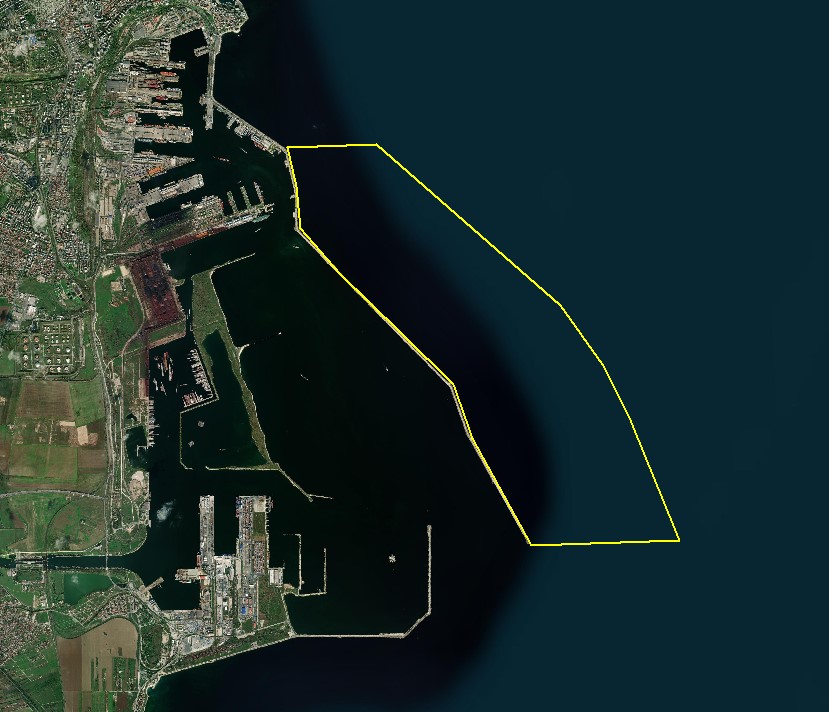
The DTM is produced with Kongsberg multibeam echosounder survey, acquired in August 2021 by Marine Research Ltd. The resolution is 1/256 arc-minutes (~7.2m). It is located at Constanta Harbour, Romania, on the coastal region of the Black Sea. Depths are referenced to the Local Sea Level - Marea Neagra 1975 and the coordinates are expressed into the WGS84 reference frame.
-
This dataset contains current data acquired between September 2016 and July 2017 using 2 TCM3 Ocean Bottom Tilt Current Meters installed next to the Tour Eiffel and Montségur hydrothermal vent sites. The TCM-3 Ocean Bottom Tilt Current Meter from Lowell Instruments LLC (North Falmouth, MA, USA) measures current using the drag-tilt principle. The logger is buoyant and is anchored to the bottom via a short flexible tether. Drag from moving water tilts the logger in the direction of flow. The logger’s accelerometer and magnetometer channels are used to record the amount of tilt and direction of tilt (compass bearing). The array comprised 3 currentmeters, deployed near the Tour Eiffel, Montségur and White Castle hydrothermal vent sites (the instrument at White Castle did not recover data). The array is not connected to an energy node. The currentmeter's internal clocks are set to UTC time before deployment. Clock drift after recovery is not implemented in data but added as metadata in the file "Sites and Sensor metadata". Important Note: This submission has been initially submitted to SEA scieNtific Open data Edition (SEANOE) publication service and received the recorded DOI. The metadata elements have been further processed (refined) in EMODnet Ingestion Service in order to conform with the Data Submission Service specifications.
-
This dataset contains current data acquired between july 2019 and June 2021 using 6 TCM-3 Ocean Bottom Tilt Current Meters installed next to the Tour Eiffel, Montségur and Crystal hydrothermal vent sites. The TCM-3 Ocean Bottom Tilt Current Meter from Lowell Instruments LLC (North Falmouth, MA, USA) measures current using the drag-tilt principle. The logger is buoyant and is anchored to the bottom via a short flexible tether. Drag from moving water tilts the logger in the direction of flow. The logger’s accelerometer and magnetometer channels are used to record the amount of tilt and direction of tilt (compass bearing). The array comprises 6 TCM-3 currentmeters, deployed near the Tour Eiffel, Montségur and Crystal hydrothermal vent sites. It is not connected to an energy node. The currentmeter's internal clocks are set to UTC time before deployment. Clock drift after recovery is not implemented in data but added as metadata in the metadata file. Important Note: This submission has been initially submitted to SEA scieNtific Open data Edition (SEANOE) publication service and received the recorded DOI. The metadata elements have been further processed (refined) in EMODnet Ingestion Service in order to conform with the Data Submission Service specifications.
-
This campaign was carried out on May 15, 2021 on the route between Puerto Juárez and the Arrowsmith Bank course or “Bajo del Este”, as the fishermen call it. The bank is located 40 km east of Punta Cancun at coordinates 21°05'00''N-86°28'00''W. The ship's captain Guillermo Antonio Carrillo Corzo alias the "Teacher", a pilot (Cap. Watermelon) and a sailor (El Chalán). The goal was carry out temperature and salinity measurements in the water column at each of the CTD stations. Direction: 10 stations with a separation of 4 km between each one were planned. Stations 1 to 6 were covered without difficulty; however, at station 7 the waves and the current increased their intensity considerably, so no progress was made to the following stations. the diagram salinity temperature profiles of each station (aligned West to East) The salinity is between 35 and 36 UPS and in turn from 28 °C to 25.5 °C. The depth ranges at the stations were from 1 to 57 m deep. Important Note: This submission has been initially submitted to SEA scieNtific Open data Edition (SEANOE) publication service and received the recorded DOI. The metadata elements have been further processed (refined) in EMODnet Ingestion Service in order to conform with the Data Submission Service specifications.
-
The mooring was deployed on 15 September 2017 from Norwegian Research Vessel Lance at 80.6°N and 7.26°E (depth of 730 m) in the Yermak Pass over the Yermak Plateau north of Svalbard. It comprised 3 instruments: an upward-looking RDI 75kHz, a Long Ranger Acoustic Doppler Current Profiler (ADCP) at 340 m with 16 m vertical resolution (25 bins of 16 m each) and a 2-hour sampling time; a Seabird SBE37 measuring temperature, salinity and pressure at 348 m with 10-minute sampling time; and an Aquadopp current meter at 645 m with a 2-hour sampling time. The mooring was retrieved on the 19 July 2020 by Norwegian Icebreaker K.V. Svalbard. The present dataset features: (i) the ADCP 50-hour smoothed daily velocities, conservative temperature and pressure time series interpolated every 10 meters within the 20-330m layer, (ii) the Aquadopp 50-hour smoothed daily velocities and pressure time series at 645 m; and (iii) the SBE37 50-hour smoothed daily conservative temperature, absolute salinity and pressure time series at 348 m. Important Note: This submission has been initially submitted to SEA scieNtific Open data Edition (SEANOE) publication service and received the recorded DOI. The metadata elements have been further processed (refined) in EMODnet Ingestion Service in order to conform with the Data Submission Service specifications.
-
Aerial surveys with bird observations around the off shore wind farm Borssele (North Sea). It is acquired for gaining insight in spatio-temporal behavior of patterns of birds. RWS case number: 31163291.
-
Ieodo Ocean Research Station (Ieodo ORS) opened in June 2003, and was built to help advance the understanding of the dynamics of the East China Sea, including its influence on Korea’s marine, terrestrial, and atmospheric environments, via the continuous and simultaneous multidisciplinary observation of local air and sea environments. Ieodo ORS is located 149 km from Marado, at the southernmost tip of Jejudo (commonly referred to in scientific literature as Jeju Island or previously as Cheju Island), southwest of the Korean Peninsula. Its steel-jacket framed tower-type platform was built near the submarine rock named “Ieodo” by the Korea Institute of Ocean Science and Technology (KIOST). The Korea Hydrographic and Oceanographic Agency (KHOA) has operated this platform since January 1, 2007. Ieodo ORS stands 36 m in height above the datum level (DL) and consists of a boat landing plus 6 decks (Bottom Deck, Intermediate Deck, Cellar Deck, Main Deck, Roof Deck, and Heli Deck). Most of its meteorological instruments and sensors are installed on the Roof Deck, including two anemometers, one barometer, two air temperature sensors, and two relative humidity sensors. Ocean temperature and salinity have been relatively consistently measured at Ieodo ORS. Aanderaa inductive-type conductivity-temperature (CT) sensors are installed at depths of 3, 20.5, and 38 m throughout the entire year, operating at 1 min sampling intervals by KHOA. Residential facilities and the electrical control room are on the Main Deck, while a seawater desalination system and a diesel generator system are installed on the Cellar Deck. Important Note: This submission has been initially submitted to SEA scieNtific Open data Edition (SEANOE) publication service and received the recorded DOI. The metadata elements have been further processed (refined) in EMODnet Ingestion Service in order to conform with the Data Submission Service specifications.
-
Socheongcho Ocean Research Station (Socheongcho ORS) opened in October 2014, and was built to help advance the understanding of the dynamics of the Yellow Sea, including its influence on Korea’s marine, terrestrial, and atmospheric environments, via the continuous and simultaneous multidisciplinary observation of local air and sea environments. Socheongcho ORS is located in the central Yellow Sea about 50 km off the western coast of the Korean Peninsula. Its steel-jacket framed tower-type platform was built near the submarine rock named “Socheongcho” by the Korea Institute of Ocean Science and Technology (KIOST). The Korea Hydrographic and Oceanographic Agency (KHOA) has operated this platform since January 1, 2016. Socheongcho ORS stands 42 m in height above the datum level (DL) and consists of a boat landing plus 7 decks (Bottom Deck, Intermediate Deck, Cellar Deck, Accommodation Deck, Main Deck, Roof Deck, and Heli Deck). Most of its meteorological instruments and sensors are installed on the Roof Deck, including two anemometers, two barometer, two air temperature sensors, and two relative humidity sensors. Ocean temperature and salinity have been relatively consistently measured at Socheongcho ORS. Aanderaa inductive-type conductivity-temperature (CT) sensors are installed at depths of 5.5 m throughout the entire year, operating at 1 min sampling intervals by KHOA. Residential facilities are on the Accommodation Deck and the electrical control room are on the Main Deck, while a seawater desalination system and a diesel generator system are installed on the Cellar Deck. Important Note: This submission has been initially submitted to SEA scieNtific Open data Edition (SEANOE) publication service and received the recorded DOI. The metadata elements have been further processed (refined) in EMODnet Ingestion Service in order to conform with the Data Submission Service specifications.
-
This dataset contains the CTD data collected during the GOMBESSA 6 cruise, from 1 to 12 July 2021, in Corsica, western Mediterranean, jointly by the (MARBEC MARine Biodiversity, Exploitation and Conservation)-[http://www.umr-marbec.fr/en/?lang=en] (France) teams. The full-depth CTD profiles were performed using an autonomous SeaBird SBE 19plus V2 SeaCAT Profiler CTD, from the Pionnier vessel belonging to (Seaowl)-[https://web.facebook.com/page.andromede/?_rdc=1&_rdr] France and chartered by the French Navy. Nine stations, from the depth of 115 m to the surface, were sampled off the Corsica coasts (western Mediterranean basin) between latitude 43.11-43.74 °N and longitude 9.49-9.52 °E. The acquisition rate was 4 Hz. The accuracy, specified by the manufacturer, were ± 0.005 °C for temperature and ± 0.0005 S/m for conductivity. The dataset is provided in different formats (CSV, NetCDF, Ocean Data View collection), which contains, for each station the following parameters: Depth [salt_water,m] Temperature [ITS-90,deg-C] pH Salinity, Practical [PSU] Conductivity [S/m] Density [kg/m^3] Oxygen [mL/L] Oxygen_sat [% saturation] Oxygen_umoll [umol/L] Turbidity [NTU] Fluorescence [mg/m^3] Light [PAR/Irradiance] QC (reference: OceanSITES quality flags http://www.oceansites.org/docs/oceansites_user_manual_version1.2.doc) Julian Days and UTC time (yyyy-mm-ddThh:mm:ss.sss) The ZIP archives contain 1/ a map of stations 2/ the list of the ID stations, geographic coordinates and general metadata 3/ all raw data acquired, for all parameters, in CNV format, 4/ the downcasts and upcasts in CSV format, 5/ the upcasts only in ODV, 6/ NetCDF and 7/ TXT formats, and 8/ two vertical profile graphs including all stations (sea water temperature and oxygen). All data acquired are publicly accessible without any restriction (under CC-BY licence). The extracted data are accessible from this GOMBESSA 6 landing page with a downloadable ZIP file. Important Note: This submission has been initially submitted to SEA scieNtific Open data Edition (SEANOE) publication service and received the recorded DOI. The metadata elements have been further processed (refined) in EMODnet Ingestion Service in order to conform with the Data Submission Service specifications.
-
As part of a Horizon 2020 JERICO-NEXT Transnational Acess project, sea surface variables (S, T, chl, O2) and macronutrient concentrations were measured by the M/S Color Fantasy FerryBox between Oslo (NO) and Kiel (DE) between January and April 2019. Important Note: This submission has been initially submitted to SEA scieNtific Open data Edition (SEANOE) publication service and received the recorded DOI. The metadata elements have been further processed (refined) in EMODnet Ingestion Service in order to conform with the Data Submission Service specifications.