 EMODnet Product Catalogue
Pipelines
Type of resources
Available actions
Topics
Keywords
Contact for the resource
Provided by
Years
Formats
Scale 1:
-
Shapefiles with features and attributes according to the Åland Islands first MSP that has been accepted by the Government of Åland
-
The Crown Estate manages the UK seabed out to the 12 nautical mile territorial sea limit and, under the 2008 Energy Act, hold the rights for gas storage within the Exclusive Economic Zone Order 2013, which extends out onto the Continental Shelf. This Order incorporated the Gas Importation and Storage Zone Order 2009, which was created by the 2008 Energy Act. Offshore natural gas storage has been taking place within UK waters, in the Rough field, since 1983. Developers of offshore projects need a storage licence (from BEIS) and a storage lease (from the Crown Estate), as set out in the 2008 Energy Act, which also explains which type of gas importation and storage projects fit into this description. Effectively the regulatory and proprietary roles are separated. This dataset shows gas storage leases given by The Crown Estate. At this stage there are three leases, Rough, Gateway and Larne Lough. Rough acts as a storage facility for gas shippers and suppliers, allowing them to feed gas into Transco's National Transmission System when demand is at its peak, or withdraw and re-inject it into the reservoir when demand is low. Any company with a UK gas shipper licence can apply to purchase storage capacity at Rough. Gateway and Larne Lough are salt caverns. This data has been checked with the lease areas held by DECC to ensure they match. The dataset also includes pipeline information. These TCE Agreements pipelines are related to the Natural Gas Storage sector in the United Kingdom waters. Attribute information includes name, tenant and pipeline type. The data source is the individual owner company of the infrastructure.
-
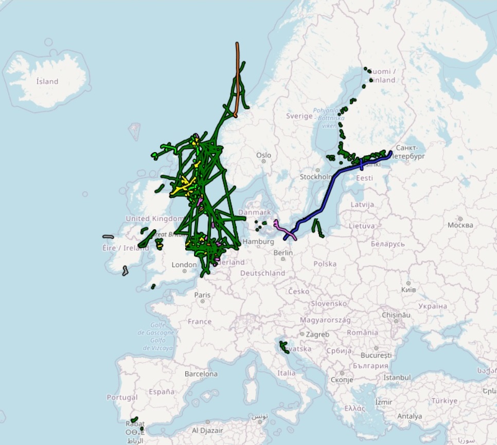
The dataset on offshore pipelines in the European waters was created in 2017 by Cogea for the European Marine Observation and Data Network (EMODnet). It is the result of the aggregation and harmonization of datasets provided by several several EU and non-EU sources. It is updated every year, and is available for viewing and download on the EMODnet web portal (Human Activities, https://emodnet.ec.europa.eu/en/human-activities). The dataset contains lines representing the actual routes of offshore pipelines (where available) in the following countries: Croatia, Denmark, Estonia, Finland, Germany, Ireland, Netherlands, Norway, Poland, Russia, Spain (Andalucía), Sweden and United Kingdom. Each line has the following harmonized attributes (where available): code, name, status (abandoned, active, application submitted, not in use, planned, pre-commissioning, proposed, under construction), medium (air, chemical glycol, chemical methanol, chemical n/a, condensate, control, cooling water, gas, geothermal heating, hydraulic, mixed hydrocarbons, oil, other fluid, sewage, water), operator, size (inches), length (metres), year, from and to locality or facility, country code, country name and notes. Compared with the previous version, this new version includes updated data from German BSH-CONTIS source.