 EMODnet Product Catalogue
unknown
Type of resources
Available actions
Topics
Keywords
Contact for the resource
Provided by
Years
Formats
Representation types
status
Service types
Scale 1:
Resolution
-
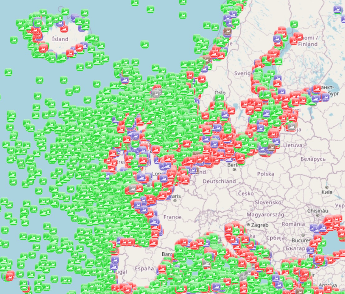
The dataset is a subset of the UK Hydrographic Office wrecks and obstructions data set. It contains over 67,000 charted, uncharted, live and dead wrecks from around the world. Where available each point has the following attributes: Wreck Id, Wreck category, Status, Position, Latitude, Longitude, Horizontal datum, Position method, Depth, Depth method, Depth quality, Depth accuracy, Water depth, Water level, Vertical datum, Name, Type, Flag, Length, Width, Draught, Sonar length, Sonar width, Shadow height, Orientation, Tonnage, Tonnage type, Cargo, Conspic visual, Conspic radar, Date sunk, Bottom texture, Scour dimensions, Debris field, Original sensor, Last sensor, Original detection, Last detection, Origin, Markers, Circumstances of loss, Surveying details, General comments, Last amended. The original dataset is updated on a quarterly basis and is made available free of charge under an Open Government Licence, which can be accessed here: https://www.nationalarchives.gov.uk/doc/open-government-licence/version/3/.
-
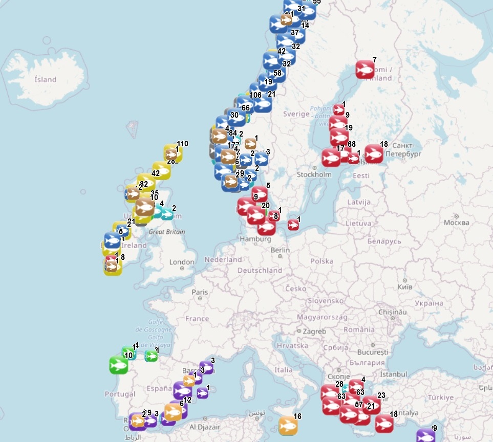
The dataset on marine finfish aquaculture in the EU was created in 2017 by AND-International for the European Marine Observation and Data Network (EMODnet). The dataset provides information about the location of marine finfish farms in the EU and partner countries where data are available. There is an obligation for EU MS to inventory all authorized aquaculture sites under the Council Directive 2006/88/EC on animal health requirements. Despite this obligation, the availability of data varies among MS from no data available at all to a complete regularly updated dataset. As far as partner countries are concerned, data have been collected only in Norway and the UK (Scotland only), where detailed data are provided online. Data provided here cover Cyprus, Denmark, Estonia, Finland, Greece, Ireland, Malta, Norway, Spain and the United Kingdom (Scotland only). Data collection is still undergoing in other EU MS and neighbouring countries. Each point has the following attributes (where available): Country, Owner name, Status (Active, n.a.), Farm type (Salmonids, Flatfish, Seabass-seabream and other coastal fish, Tuna, Other, n.a.), Production method (Sea cages, Saltwater tanks/raceways, Saltwater ponds, Saltwater closed (recirculation), Quarantine, Other, n.a.), Production stage (Grow out for human consumption, Hatchery, Nursery, Broodstock, Reproduction, Restoration of wild stock, Put and take fisheries, Processing facility, Slaughtering facility, Research facility, Sea ranching, Other, n.a.), Purpose (Commercial, Display, Education, Research, Capture-based aquaculture, Fishing park, Other, n.a.), Species_source (detailed information on species names as presented in the source and translated to English), Point information (Polygon centroid, Original) depending on how the information is provided in the source (polygons or points), Site_ID, the distance to coast (in meters), the position from Coastline (At sea or Within the coastline), the ID from the source to facilitate traceability, and the year the data was updated in the source. The farm type relies on a typology established by AND-International, based on available information on species grown. A relational table provides harmonised information about species grown using Eurostat nomenclature for the Species Group, the species name (commercial and scientific) and the Eurostat code (ALPHA-3 code for species). The data has been updated for all countries available and additional fields were added to improve traceability (ID from source and Year updated in the source). Data from Spain are available for viewing but not for download. Data from other countries are available for viewing and download.
-
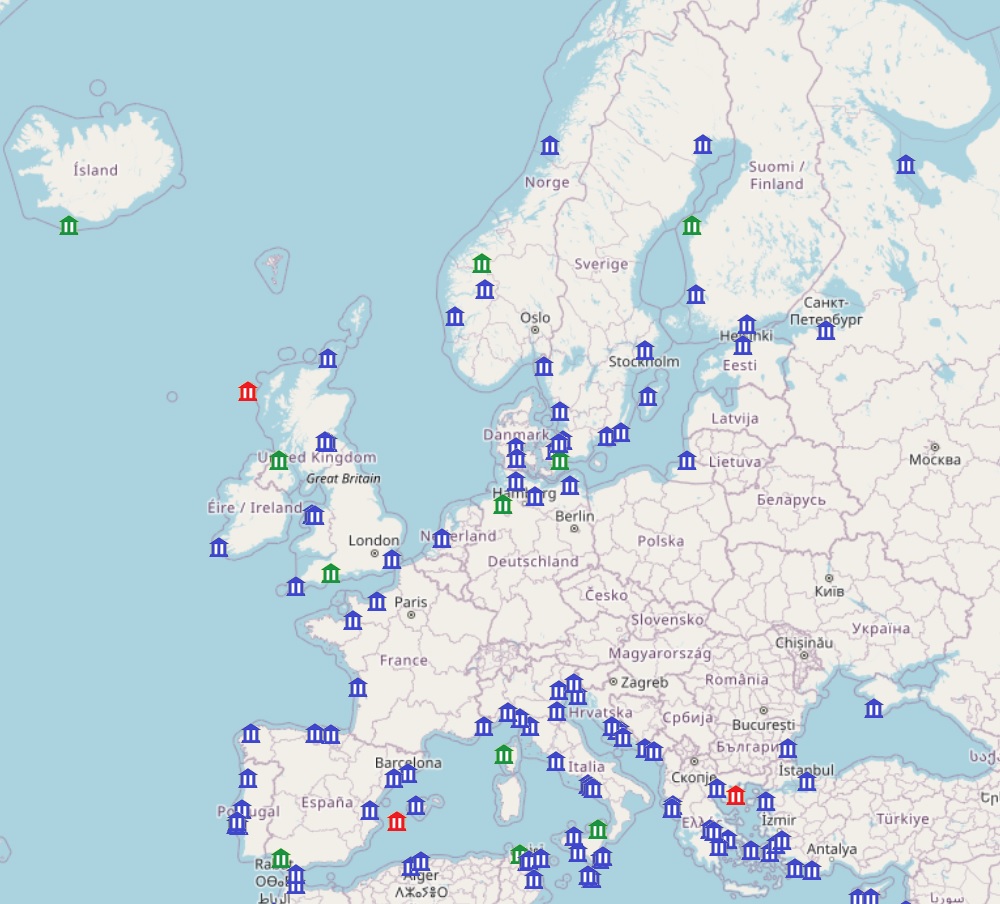
This dataset provides the location of coastal sites from the UNESCO World Heritage Convention list. It includes Unseco sites considered as coastal according to the definition of costal areas provided by the European Commission: coastal areas are local administrative units (LAUs) that are bordering or close to a coastline. A coastline is defined as the line where land and water surfaces meet (border each other). Coastal areas have at least 50% of their surface area within a distance of 10km from the coastline. The dataset includes the name of the sites, its code in the Unesco site database, the distance to coast, whether it is a cultural or natural site and a short description from the Unesco. It is available for viewing and download on the EMODnet web portal (Human Activities, https://emodnet.ec.europa.eu/en/human-activities).
-
The dataset on fishing quotas by Fishery Management Zones (FMZs) was created in 2024 by Cogea for the European Marine Observation and Data Network (EMODnet). It is based on DG MARE's data and it is available for viewing and download on EMODnet web portal (Human Activities, https://emodnet.ec.europa.eu/en/human-activities). Total allowable catches (TACs), as Initial Quantity and Adapted Quota, are catch limits (expressed in tonnes) provided for each fish species (code and name) for a given year. Each stock is associated with one FMZ, but a FMZ can have multiple Stocks associated with it. Each species+area combination (stock) has multiple quota values per year. Quota values of the level'TAC' represent total allowable catch (sum of EU and third countries’ quotas). 'EEC' is the EU quota, which is the sum of individual Member States’ quotas. Thus in visualising the values of the quotas, the level needs to be taken into account. For many stocks, there is no value in the quota table. This means that the stock is defined only for reporting purposes, but there is no limitation of the amount of allowable catches. Due to the amount of data, all the attributes are not shown in the mapviewer, thus it is recommended to download the data in order to access to all the available info. The dataset is updated yearly and it covers a time series from 2012 onwards.
-
The dataset on the shellfish protected areas under the Water Framework Directive (WFD) was created in 2023 by AND-International for the European Marine Observation and Data Network (EMODnet). The Directive (Article 6, paragraphs 1 and 2) requires Member States to designate areas which require specific protection of their surface water and groundwater, or for the conservation of habitats and species directly depending on water. According to Annex IV (ii) of the WFD, these areas should include areas designated for the protection of economically significant aquatic species (shellfish in this case). This dataset compiles the designated areas as provided by national sources (The Department of Housing, Planning, Community and Local Government of Ireland and The Ministry for Ecological Transition and Demography in Spain) and it is available for viewing and download on EMODnet web portal (Human Activities, https://emodnet.ec.europa.eu/en/human-activities). Each polygon has the following attributes: area ID (in EMODnet), country, area name, designation date, ID from the source.
-
The dataset on licensed sites of shellfish aquaculture in the EU was created in 2023 by AND-International for the European Marine Observation and Data Network (EMODnet). It is the result of the aggregation and harmonization of datasets provided by national sources representing the delimitation of shellfish farms (polygons) in the following countries: France, Ireland and Spain. Data from France and Spain comes from national and regional cadastral data, while data from Ireland comes from the list of registered aquaculture sites. Each polygon has the following attributes (where available): country, expiration date, farm type (Mussels, Oysters, Mussels-Oysters, Clams, Specialised (other), Mixed (other)), species from the source (English translation of the information provided on species grown or authorised in the source), production method (Beds, Long lines, Rafts, Saltwater closed (recirculation), Saltwater ponds, Saltwater tanks/raceways, Trestles or trays, Bouchot, On-bottom, Sea cages, Other), production stage (Broodstock, Grow out for human consumption, Harvest, Hatchery, Nursery, Reproduction, Wild capture of seeds, Purification, Maturing, Other), purpose (only specified for some sites authorised for research purposes), polygon information (Lines to Polygon or Original) depending on how the information is provided in the source (polygons or lines), site_id, year updated (in the source), shape length and shape area. The farm type relies on a typology established by AND-International, based on available information on species grown or authorised. A relational table provides harmonised information about species grown or authorised using Eurostat nomenclature for the Species Group (Mussels; Oysters; Clams, cockles, arkshells; Scallops, pectens; Abalones, winkles, conchs; Sea-urchins and other echinoderms) and when available the species name (e.g. Blue mussels - Mytilus edulis). Data are available for viewing and download on EMODnet - Human Activities web portal ( https://emodnet.ec.europa.eu/en/human-activities), except for the data from Spain, which are available in the viewer, but not for download.
-
The dataset on ocean energy in the European seas was created in 2014 by AZTI for the European Marine Observation and Data Network (EMODnet). It is the result of the aggregation and harmonization of datasets provided by several sources from all across the European countries. It is updated every year, and is available for viewing and download on EMODnet web portal (Human Activities, https://emodnet.ec.europa.eu/en/human-activities). The dataset contains points representing Ocean Energy project sites in the following countries: Belgium, Denmark, Finland, France, Ireland, Italy, Norway, Portugal, Russia, Spain, Sweden, The Netherlands and United Kingdom. Where available, each point has the following attributes: site code (ID_1), project code (ID), name, location, country, sea basin, sea, distance to coast (metres), resource type (wave, tidal, salinity gradient, wave/wind), starting year, ending year, lease status, technology (Based on www.aquaret.com/), device, device scale (Full scale, prototype, etc.), project scale (Commercial, Demonstrator Array, etc.), project status (operational, completed, etc.), project capacity (KW), promoter, position info (it indicates if the attribute value is original from the source or has been estimated or calculated the polygon centroid) and the studies conducted for the environmental assessment (EIA). In 2016, a feature on areas for ocean energy test sites was included. It contains polygons representing Ocean Energy test sites in the following countries: Denmark, France, Ireland, Norway, Portugal, Spain, Sweden, The Netherlands and United Kingdom. Where available, each polygon has the following attributes: test site code, name, location, country, sea basin, sea, distance to coast (metres), resource type (wave, tidal), starting year, ending year, lease status, site status, capacity (kW), depth (metres), area (square km), grid connection, number of berths, developer, position info (it indicates if the attribute value is original from the source or has been estimated) and the studies conducted for the Environmental Assessment (EIA). In 2024, new data has been included and existing data has been updated.
-
This dataset provides the location of lighthouses inventoried by the Amateur Radio Lighthouse Society (ARLS). It includes both existing lighthouses and historical ones that have been removed, relocated or destroyed (column Status). The dataset includes the name of the lighthouse, its code in the ARLSH database, the status, the distance to coast, whether it is located at sea or within the coastline and some comments when the ARLSH information has been edited based on information from other sources. Coordinates are approximate for most of the lighthouses.It is updated every 2 years, and is available for viewing and download on the EMODnet web portal (Human Activities, https://emodnet.ec.europa.eu/en/human-activities). Re-use for commercial and non-commercial purpose requires written consent from the ARLHS.
-
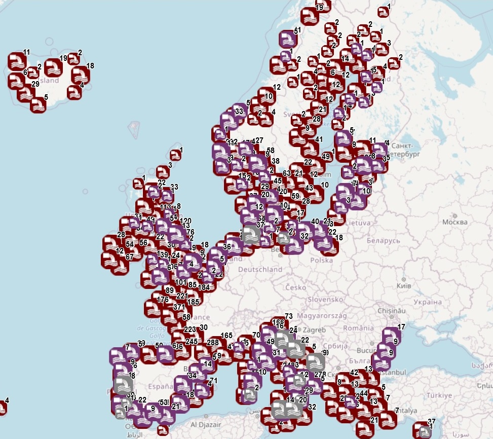
The dataset on coastal discharge points from Urban Waste Water Treatment Plant (UWWTP) was created in 2019 by AZTI for the European Marine Observation and Data Network (EMODnet). It is based on the dataset "Waterbase-UWWTD" (Urban Waste Water Treatment Directive – reported data) provided by the European Topic Centre on Inland, Coastal and Marine waters, and made available at https://www.eea.europa.eu/data-and-maps/data/waterbase-uwwtd-urban-waste-water-treatment-directive-8. The dataset is available for viewing and download on EMODnet web portal (Human Activities, https://emodnet.ec.europa.eu/en/human-activities) and it presents the available information (location of discharge points, link to specific treatment plant, type of receiving area into which the effluent/wastewater is discharged, related waterbody/river basin) on individual points of discharge from treatment plants or collecting systems located in coastal NUTS3 regions, based on data selected from the reporting of Member States as part of the UWWTD implementation. The geographic coverage is: Belgium, Bulgaria, Croatia, Cyprus, Denmark, Estonia, Finland, France, Germany, Greece, Iceland, Ireland, Italy, Latvia, Lithuania, Malta, Netherlands, Norway, Poland, Portugal, Romania, Slovenia, Spain, Sweden, United Kingdom. The description of all attribute fields of UWWTP is given in the Waterbase-UWWTD (https://www.eea.europa.eu/data-and-maps/data/waterbase-uwwtd-urban-waste-water-treatment-directive-8/waterbase-uwwtd). In this update, data provided by several countries during 2022 (Waterbase reported under UWWTD data call 2021; version 10 publised 15 January 2023) are included.
-
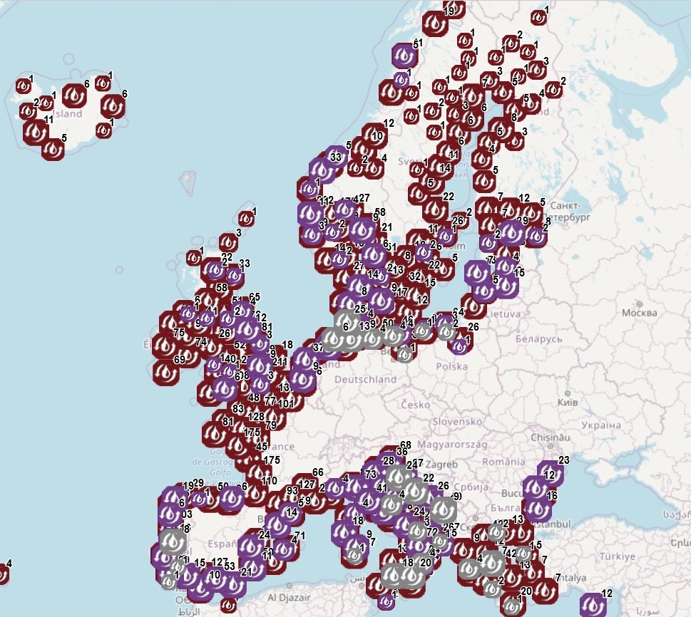
The datset on coastal Urban Waste Water Treatment Plant (UWWTP) was created in 2019 by AZTI for the European Marine Observation and Data Network (EMODnet). It is based on the dataset "Waterbase-UWWTD" (Urban Waste Water Treatment Directive – reported data) provided by the European Topic Centre on Inland, Coastal and Marine waters, and made available at https://www.eea.europa.eu/en/datahub/datahubitem-view/6244937d-1c2c-47f5-bdf1-33ca01ff1715. The datset is available for viewing and download on EMODnet - Human Activities web portal (https://emodnet.ec.europa.eu/en/human-activities). Based on data selected from the reporting of Member States as part of the UWWTD implementation, the dataset presents the available information (location, capacity and actual load treated, type of treatment, aggregated data on the performance of plants) on individual UWWTP, and collecting systems without UWWTP, located in NUTS3 regions bordering transitional, coastal and marine waters. The geographic coverage is: Belgium, Bulgaria, Croatia, Cyprus, Denmark, Estonia, Finland, France, Germany, Greece, Iceland, Ireland, Italy, Latvia, Lithuania, Malta, Netherlands, Norway, Poland, Portugal, Romania, Slovenia, Spain, Sweden, United Kingdom. The description of all attribute fields of UWWTP is given in the Waterbase-UWWTD (https://www.eea.europa.eu/en/datahub/datahubitem-view/6244937d-1c2c-47f5-bdf1-33ca01ff1715). In this update, data provided by several countries during 2022 (Waterbase reported under UWWTD data call 2021; version 10 publised 15 January 2023) are included.