 EMODnet Product Catalogue
broad-scale
Type of resources
Available actions
Topics
Keywords
Contact for the resource
Provided by
Formats
Representation types
Update frequencies
status
Scale 1:
-
This layer is a predictive EUNIS seabed habitat map for the Canary Islands. It was performed within the framework of EMODnet Phase 2 Thematic Lot n┬░ 3 (aka EUSeaMap2). It is a preliminary version which will be refined during the course of the project. The layer was created using two pre-processed input datasets: substrate and biological zone. The seabed substrate type layer was a compendium of historical maps (Emodnet phase 2 Geology lot first release + Datasets from Instituto Espa├▒ol de Oceanograf├¡a). The biological zones layer, available in this catalog under the title 'Biological zones of the Canary Islands and Madeira archipelago', was modeled thanks to layers of bathymetry and light attenuation. The map follows the EUNIS 2007-11 classification system supplemented by additional categories in deep sea areas (Howell et al., 2010). The map does not include the intertidal zone. The study followed the methodology developped within the EUSeaMap project (EMODnet phase 1). For more details about the methodology see EUSeaMap final report (Cameron and Askew, 2011) or Coltman et al., 2008. For more details about the current map see EUSeaMap2 interim report (EMODnet Thematic Lot n┬░ 3, 2014) Cameron, A., Askew, N. (eds.), 2011. EUSeaMap - Preparatory Action for development and assessment of a European broad-scale seabed habitat map final report. URL: http://jncc.gov.uk/euseamap Coltman, N., Golding, N., Verling, E., 2008. Developing a broadscale predictive EUNIS habitat map for the MESH study area. 16 pp. URL: https://www.emodnet-seabedhabitats.eu/resources/mesh-archive/. EMODnet Thematic Lot n┬░ 3, 2014. EMODnet Phase 2 - Annual (interim) report. Reporting Period: Sept. 2013 to Aug. 2014. URL: http://www.emodnet-seabedhabitats.eu/pdf/20140909_euseamap2_year1_report.pdf Howell, K.L., 2010. A benthic classification system to aid in the implementation of marine protected area networks in the deep/high seas of the NE Atlantic. Biological Conservation 143, 1041ÔÇô1056.
-
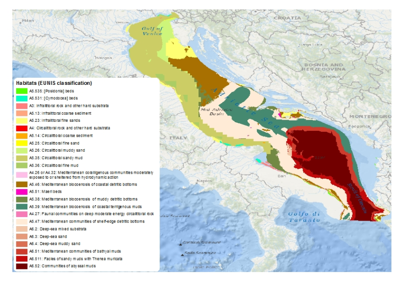
This layer is a predictive EUNIS seabed habitat map for the Adriatic Sea. It was performed within the framework of EMODnet Phase 2 Thematic Lot n┬░ 3 (aka EUSeaMap2). It is a preliminary version which will be refined during the course of the project. The layer was created using two pre-processed input datasets: substrate and biological zone. The seabed substrate type layer was a compendium of historical maps (Emodnet phase 2 Geology lot first release + IBCM map). The biological zones layer, available in this catalog under the title 'Biological zones of the Adriatic Sea', was modeled thanks to layers of bathymetry and light attenuation. The map follows the EUNIS 2007-11 classification system. It does not include the intertidal zone. The study followed the methodology developped within the EUSeaMap project (EMODnet phase 1). For more details about the methodology see EUSeaMap final report (Cameron and Askew, 2011) or Coltman et al., 2008. For more details about the current map see EUSeaMap2 interim report (EMODnet Thematic Lot n┬░ 3, 2014) Cameron, A., Askew, N. (eds.), 2011. EUSeaMap - Preparatory Action for development and assessment of a European broad-scale seabed habitat map final report. URL: http://jncc.gov.uk/euseamap Coltman, N., Golding, N., Verling, E., 2008. Developing a broadscale predictive EUNIS habitat map for the MESH study area. 16 pp. URL: https://www.emodnet-seabedhabitats.eu/resources/mesh-archive/. EMODnet Thematic Lot n┬░ 3, 2014. EMODnet Phase 2 - Annual (interim) report. Reporting Period: Sept. 2013 to Aug. 2014. URL: http://www.emodnet-seabedhabitats.eu/pdf/20140909_euseamap2_year1_report.pdf
-
This layer is a predictive EUNIS seabed habitat map for the Atlantic area. The layer has been created using three pre-processed input datasets: substrate, biological zone and energy. The seabed substrate type layer is a compendium of historical maps. The biological zones layer was modeled thanks to layers of bathymetry, light attenuation, and wave wavelength. The layer of energy was prepared thanks to archived results of numerical models of waves and currents. The map follows the EUNIS 2007-11 classification system supplemented by additional categories in deep sea areas (Howell et al., 2010). The map does not include the intertidal zone. The study followed the methodology developped within the EUSeaMap project. For more details about the methodology see EUSeaMap final report (Cameron and Askew, 2011) or Coltman et al., 2008 For more details about the substrate and bathymetry that were used as a basis see Mata Chac├│n et al. Cameron, A., Askew, N. (eds.), 2011. EUSeaMap - Preparatory Action for development and assessment of a European broad-scale seabed habitat map final report. URL: http://jncc.gov.uk/euseamap Coltman, N., Golding, N., Verling, E., 2008. Developing a broadscale predictive EUNIS habitat map for the MESH study area. 16 pp. URL: https://www.emodnet-seabedhabitats.eu/resources/mesh-archive/. Howell, K.L., 2010. A benthic classification system to aid in the implementation of marine protected area networks in the deep/high seas of the NE Atlantic. Biological Conservation 143, 1041ÔÇô1056. Mata Chac├│n, D., Sanz Alonso, J.L., Gon├ºalves, J.M.S., Monteiro, P., Bentes, L., McGrath, F., Henriques, V., Freitas, R., Amorim, P., Tempera, F., Fossecave, P., Alonso, C., Galparsoro, I., Vasquez, M., Populus, J. (2013). Report on collation of historic maps. Bathymetry, substrate and habitats ÔÇô MeshAtlantic Report. Spanish Institute of Oceanography. 98 pp.