 EMODnet Product Catalogue

Type of resources
Available actions
Topics
Keywords
Contact for the resource
Provided by
Years
Formats
Representation types
Update frequencies
status
Service types
Scale 1:
Resolution
-
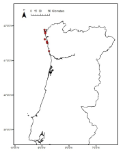
Cymodocea nodosa meadows distribution in the south of Portugal from historical data. Data provided by the Life Project BIOMARES and published in: ÔÇ£Seagrasses in Portugal: A most endangered marine habitatÔÇØ. Aquatic Botany. doi:10.1016/j.aquabot.2011.08.007. ÔÇ£Estimation of available seagrass meadows area in Portugal for transplanting purposes ÔÇØ. Journal of Coastal Research (2009) :SI 56 (1100-1104)
-
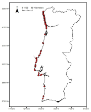
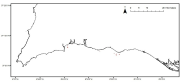
Laminaria ochroleuca distribution in the Portuguese mainland from historical data. Data provided by the Project FindKelp and published in: ÔÇ£Findkelp, a GIS-based Community Participation Project to Assess Portuguese Kelp Conservation StatusÔÇØ. Journal of Coastal Research (2009) :SI 56 (1469-1473)
-
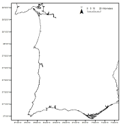
Saccorhiza polyschides distribution in the Portuguese mainland from historical data. Data provided by the Project FindKelp and published in: ÔÇ£Findkelp, a GIS-based Community Participation Project to Assess Portuguese Kelp Conservation StatusÔÇØ. Journal of Coastal Research (2009) :SI 56 (1469-1473)
-
Zostera marina meadows distribution in the Portuguese mainland from historical data. Data provided by the Life Project BIOMARES and published in: ÔÇ£Seagrasses in Portugal: A most endangered marine habitatÔÇØ. Aquatic Botany. doi:10.1016/j.aquabot.2011.08.007. ÔÇ£Estimation of available seagrass meadows area in Portugal for transplanting purposes ÔÇØ. Journal of Coastal Research (2009) :SI 56 (1100-1104)
-
UKSeaMap 2016 has been generated by JNCC and is a by-product of the 2013-2016 activities of the EMODnet Seabed Habitats 2013-2016 consortium. It is a composite of two broad-scale habitat maps, arranged in the following priority order: 1. A roughly 100 m* resolution broad-scale habitat map, which covers the majority of the UK shelf area. 2. EUSeaMap 2016, a coarser resolution** broad-scale habitat map, which covers all European seas (view/download on the EMODnet Seabed Habitats interactive map). Both of these datasets have been created using identical methods; the only difference is in the resolution of the seabed substrate input data and the source and resolution of the depth data. Classification systems: EUNIS habitat classification system, with additional deep sea zones MSFD predominant habitats The Marine Habitat Classification for Britain and Ireland Input data layers: Seabed substrate type Depth to the seabed Amount of light reaching the seabed Wave disturbance at the seabed Kinetic energy at the seabed caused by tidal currents and waves Outputs: Predictive seabed habitat map Confidence layers The map follows the EUNIS 2007-11 classification system where it is appropriate.
-
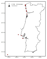
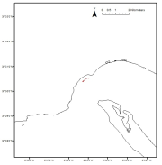
Maerl beds distribution in the Portuguese mainland from historical data. Data published in: ÔÇ£Present distribution of maerl beds in the Atlantic Iberian PeninsulaÔÇØ. Museologia Scientifica e Naturalista. Volume Speciale 2009
-
Zostera noltii meadows distribution in the Portuguese mainland from historical data. Data provided by the Life Project BIOMARES and published in: ÔÇ£Seagrasses in Portugal: A most endangered marine habitatÔÇØ. Aquatic Botany. doi:10.1016/j.aquabot.2011.08.007. ÔÇ£Estimation of available seagrass meadows area in Portugal for transplanting purposes ÔÇØ. Journal of Coastal Research (2009) :SI 56 (1100-1104)
-
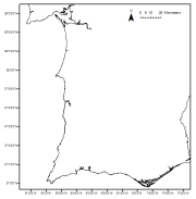
Laminaria hyperborea distribution in the Portuguese mainland from historical data. Data provided by the Project FindKelp and published in: ÔÇ£Findkelp, a GIS-based Community Participation Project to Assess Portuguese Kelp Conservation StatusÔÇØ. Journal of Coastal Research (2009) :SI 56 (1469-1473)
-
Data were collected in the framework for the stablishment of the Capo Milazzo AMP. The study was founded by MATTM. The map was constructed by using acustic data, direct observations by ROV and satellite images.
-

Data holdings of individual modelled maps of specific habitats. These models have been collated by EMODnet Seabed Habitats partners from a variety of sources. Ownership of the individual models is retained by the original owners, for more information please see the individual metadata record tied to the model, which can be seen in the data layer. Models are available individually through EMODnet Seabed Habitats' "maplibrary" OGC service endpoints: For WMS (view) access to models, please use https://ows.emodnet-seabedhabitats.eu/geoserver/emodnet_view_maplibrary/wms? For WCS (download) access to open models, please use https://ows.emodnet-seabedhabitats.eu/geoserver/emodnet_open_maplibrary/wcs?