 EMODnet Product Catalogue
Shapefile
Type of resources
Available actions
Topics
Keywords
Contact for the resource
Provided by
Years
Formats
Representation types
Update frequencies
status
Scale 1:
Resolution
-
Cymodocea nodosa meadows distribution in the south of Portugal from historical data. Data provided by the Life Project BIOMARES and published in: ÔÇ£Seagrasses in Portugal: A most endangered marine habitatÔÇØ. Aquatic Botany. doi:10.1016/j.aquabot.2011.08.007. ÔÇ£Estimation of available seagrass meadows area in Portugal for transplanting purposes ÔÇØ. Journal of Coastal Research (2009) :SI 56 (1100-1104)
-
Zostera noltii meadows distribution in the Portuguese mainland from historical data. Data provided by the Life Project BIOMARES and published in: ÔÇ£Seagrasses in Portugal: A most endangered marine habitatÔÇØ. Aquatic Botany. doi:10.1016/j.aquabot.2011.08.007. ÔÇ£Estimation of available seagrass meadows area in Portugal for transplanting purposes ÔÇØ. Journal of Coastal Research (2009) :SI 56 (1100-1104)
-
Maerl beds distribution in the Portuguese mainland from historical data. Data published in: ÔÇ£Present distribution of maerl beds in the Atlantic Iberian PeninsulaÔÇØ. Museologia Scientifica e Naturalista. Volume Speciale 2009
-
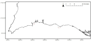
Saccorhiza polyschides distribution in the Portuguese mainland from historical data. Data provided by the Project FindKelp and published in: ÔÇ£Findkelp, a GIS-based Community Participation Project to Assess Portuguese Kelp Conservation StatusÔÇØ. Journal of Coastal Research (2009) :SI 56 (1469-1473)
-
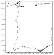
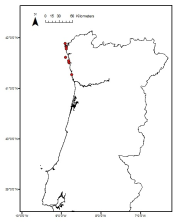
Laminaria ochroleuca distribution in the Portuguese mainland from historical data. Data provided by the Project FindKelp and published in: ÔÇ£Findkelp, a GIS-based Community Participation Project to Assess Portuguese Kelp Conservation StatusÔÇØ. Journal of Coastal Research (2009) :SI 56 (1469-1473)
-
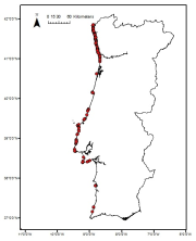
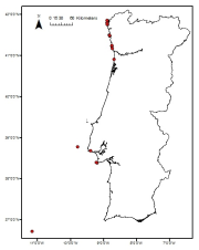
Laminaria hyperborea distribution in the Portuguese mainland from historical data. Data provided by the Project FindKelp and published in: ÔÇ£Findkelp, a GIS-based Community Participation Project to Assess Portuguese Kelp Conservation StatusÔÇØ. Journal of Coastal Research (2009) :SI 56 (1469-1473)
-
Zostera marina meadows distribution in the Portuguese mainland from historical data. Data provided by the Life Project BIOMARES and published in: ÔÇ£Seagrasses in Portugal: A most endangered marine habitatÔÇØ. Aquatic Botany. doi:10.1016/j.aquabot.2011.08.007. ÔÇ£Estimation of available seagrass meadows area in Portugal for transplanting purposes ÔÇØ. Journal of Coastal Research (2009) :SI 56 (1100-1104)
-
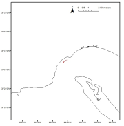
Data were collected in the framework for the stablishment of the Capo Milazzo AMP. The study was founded by MATTM. The map was constructed by using acustic data, direct observations by ROV and satellite images.
-
This layer shows the current known extent and distribution of live hard coral cover in European waters, collated by EMODnet Seabed Habitats. The point and polygon layers were last updated in 2023. Lophelia pertusa and Coral gardens are both on the OSPAR List of threatened and/or declining species and habitats. The purpose was to produce a data product that would provide the best compilation of evidence for the essential ocean variable (EOV) known as Hard coral cover and composition (sub-variable: Live hard coral cover and extent), as defined by the Global Ocean Observing System (GOOS). The geographic extent of this product was extended in 2023 to include jurisdictional waters (including continental shelf and claimed extended continental shelf) of EU Member States, the United Kingdom (UK) and Norway including areas in the Caribbean Sea.
-
This layer shows the current known extent and distribution of Seagrass meadows in European waters, collated by EMODnet Seabed Habitats. The point and polygon layers were last updated in 2023.The purpose was to produce a data product that would provide the best compilation of evidence for the essential ocean variable (EOV) known as Seagrass cover and composition (sub-variable: Areal extent of seagrass meadows), as defined by the Global Ocean Observing System (GOOS). Seagrasses provide essential habitat and nursery areas for many marine fauna. There are approximately 72 seagrass species that belong to four major groups: Zosteraceae, Hydrocharitaceae, Posidoniaceae and Cymodoceaceae. Zostera beds and Cymodecea meadows are named on the OSPAR Threatened or Declining Habitats list. Posidonia beds are protected under Annex I of the EU Habitats Directive. The geographic extent of this product was extended in 2023 to include jurisdictional waters (including continental shelf and claimed extended continental shelf) of EU Member States, the United Kingdom (UK) and Norway including areas in the Caribbean Sea.