 EMODnet Product Catalogue
Regional Hydrological Administration of the Algarve (ARH Algarve)
Type of resources
Available actions
Topics
Keywords
Contact for the resource
Provided by
Years
Formats
Representation types
Update frequencies
status
Scale 1:
-
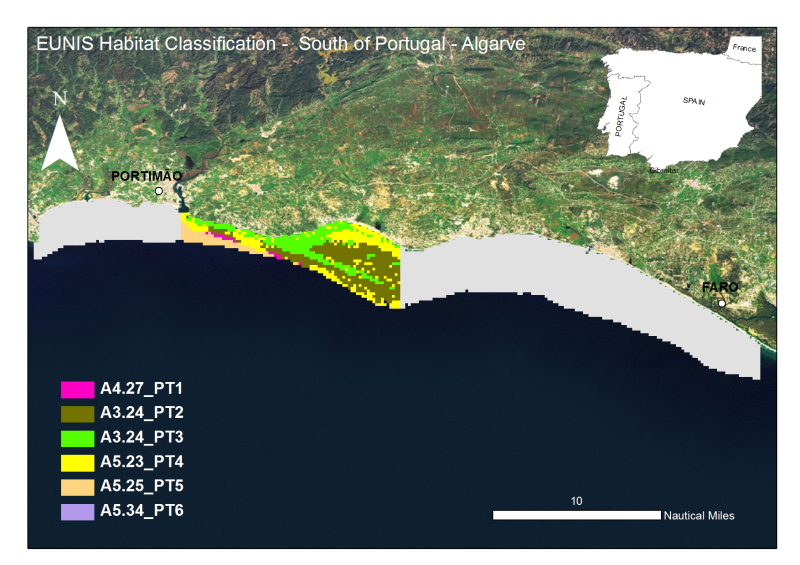
The Algarve coast presents a significant portion of territory that is part of the designated National Nature Reserve, in its underwater slope (0 to 30m depth - RENSUB), especially when compared with the equivalent on land. The current digital map presents the EUNIS habitat of the central Algarve RENSUB coast. The covered area is between Rio Arade and Ponta da Piedade. The sediment classification was obtained through the interpretation of data from Side Scan Sonar (remote-sensing image), while for the habitat mapping the biological sampling was carried out with beam trawl and underwater visual census.
-
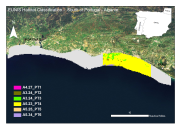
The Algarve coast presents a significant portion of territory that is part of the designated National Nature Reserve, in its underwater slope (0 to 30m depth - RENSUB), especially when compared with the equivalent on land. The current digital map presents the EUNIS habitat of the central Algarve RENSUB coast. The covered area is between Gal├® and Barra do Anc├úo. The sediment classification was obtained through the interpretation of data from Side Scan Sonar (remote-sensing image), while for the habitat mapping the biological sampling was carried out with beam trawl and underwater visual census.
-
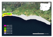
The Algarve coast presents a significant portion of territory that is part of the designated National Nature Reserve, in its underwater slope (0 to 30m depth - RENSUB), especially when compared with the equivalent on land. The current digital map presents the EUNIS habitat of the central Algarve RENSUB coast. The covered area is between Gal├® and Rio Arade. The sediment classification was obtained through the interpretation of data from Side Scan Sonar (remote-sensing image), while for the habitat mapping the biological sampling was carried out with beam trawl and underwater visual census.
-
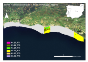
The Algarve coast presents a significant portion of territory that is part of the designated National Nature Reserve, in its underwater slope (0 to 30m depth - RENSUB), especially when compared with the equivalent on land. The current digital map presents the EUNIS habitat of the central Algarve RENSUB coast. The covered area is between Albufeira and Vale do Lobo. The sediment classification was obtained through the interpretation of data from Side Scan Sonar (remote-sensing image), while for the habitat mapping the biological sampling was carried out with beam trawl and underwater visual census.