 EMODnet Product Catalogue
Date and time
Type of resources
Available actions
Topics
Keywords
Contact for the resource
Provided by
Years
Formats
Representation types
Scale 1:
Resolution
-
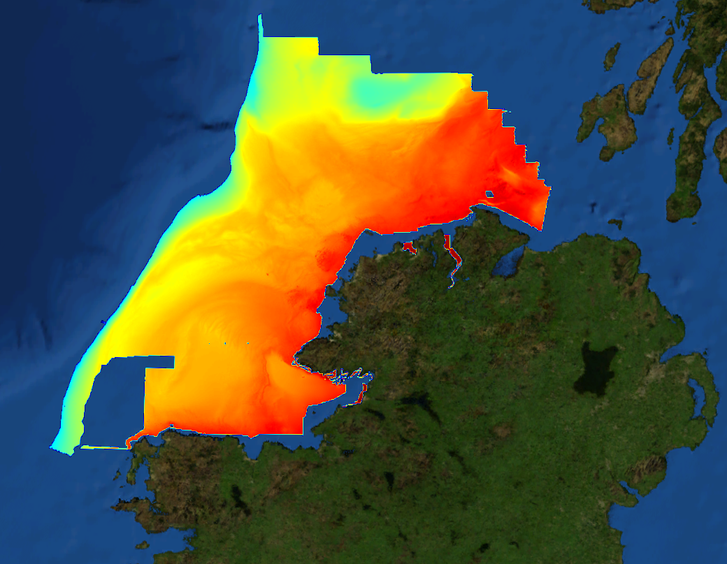
This composite Digital Terrain Model (cDTM) is a high resolution bathymetry dataset highlighting measurement of depth of water in the ocean. This cDTM covers the North Atlantic Ocean off the coast of County Donegal in Ireland. The EMODnet high resolution DTM covers bathymetry surveys completed between 2002 and 2016. Bathymetric data collected on board research vessels using multi-beam and single-beam echosounder instrumentation. Raw bathymetry processed within CARIS software to produce bathymetry products subsequently converted to NetCDF cDTM for EMODnet. Acquisition, processing and product delivery follows IHO standard s44 Edition 5. cDTM is composed of eighteen (18) images “merged simply” using GLOBE software. INFOMAR (Integrated Mapping for the Sustainable Development of Ireland’s Marine Resource) is a twenty year programme to map the physical, chemical and biological features of Ireland’s seabed established in 2006. INFOMAR is funded by the Department of Communications, Climate Action and Environment (DCCAE), and delivered by joint management partners Geological Survey Ireland and the Marine Institute. The programme is the successor to the Irish National Seabed Survey (INSS) which ran between 1999 and 2005. INFOMAR concentrates on creating integrated mapping products related to the seabed.
-

EMODnet Chemistry aims to provide access to marine chemistry data sets and derived data products concerning eutrophication, ocean acidification and contaminants. The chemicals chosen reflect importance to the Marine Strategy Framework Directive (MSFD). This regional aggregated dataset contains all unrestricted EMODnet Chemistry data on contaminants (20 parameters), and covers the North East Atlantic Ocean with 2400 CDI records divided per matrices: 122 in biota (as time series), 1689 in water (as vertical profiles), 589 in sediment (478 Vertical profiles and 111 Time series). Vertical profiles temporal range is from 1970-07-29 to 2017-02-28. Time series temporal range is from 1979-02-28 to 2014-10-21. Data were aggregated and quality controlled by ‘IFREMER / IDM / SISMER - Scientific Information Systems for the SEA’ from France. Regional datasets concerning contaminants are automatically harvested. Parameter names in these datasets are based on P01, BODC Parameter Usage Vocabulary, which is available at: http://seadatanet.maris2.nl/bandit/browse_step.php . Each measurement value has a quality flag indicator. The resulting data collections for each Sea Basin are harmonised, and the collections are quality controlled by EMODnet Chemistry Regional Leaders using ODV Software and following a common methodology for all Sea Regions. Harmonisation means that: (1) unit conversion is carried out to express contaminant concentrations with a limited set of measurement units (according to EU directives 2013/39/UE; Comm. Dec. EU 2017/848) and (2) merging of variables described by different “local names” ,but corresponding exactly to the same concepts in BODC P01 vocabulary. The harmonised dataset can be downloaded as ODV spreadsheet (TXT file), which is composed of metadata header followed by tab separated values. This worksheet can be imported to ODV Software for visualisation (More information can be found at: https://www.seadatanet.org/Software/ODV ). The same dataset is offered also as XLSX file in a long/vertical format, in which each P01 measurement is a record line. Additionally, there are a series of columns that split P01 terms in subcomponents (measure, substance, CAS number, matrix...).This transposed format is more adapted to worksheet applications users (e.g. LibreOffice Calc). The 20 parameter names in this metadata record are based on P02, SeaDataNet Parameter Discovery Vocabulary, which is available at: http://seadatanet.maris2.nl/v_bodc_vocab_v2/vocab_relations.asp?lib=P02 . Detailed documentation will be published soon. The original datasets can be searched and downloaded from EMODnet Chemistry Download Service: https://emodnet-chemistry.maris.nl/search
-

EMODnet Chemistry aims to provide access to marine chemistry data sets and derived data products concerning eutrophication, ocean acidification and contaminants. The chemicals chosen reflect importance to the Marine Strategy Framework Directive (MSFD). This regional aggregated dataset contains all unrestricted EMODnet Chemistry data on contaminants (59 parameters), and covers the North Sea with 34978 CDI records divided per matrices: 3909 biota time series, 28071 water profiles, 2998 sediment profiles. Vertical profiles temporal range is from 1970-02-17 to 2017-10-26. Time series temporal range is from 1979-02-26 to 2017-02-28. Data were aggregated and quality controlled by ‘Aarhus University, Department of Bioscience, Marine Ecology Roskilde from Denmark. Regional datasets concerning contaminants are automatically harvested. Parameter names in these datasets are based on P01, BODC Parameter Usage Vocabulary, which is available at: http://seadatanet.maris2.nl/bandit/browse_step.php . Each measurement value has a quality flag indicator. The resulting data collections for each Sea Basin are harmonised, and the collections are quality controlled by EMODnet Chemistry Regional Leaders using ODV Software and following a common methodology for all Sea Regions. Harmonisation means that: (1) unit conversion is carried out to express contaminant concentrations with a limited set of measurement units (according to EU directives 2013/39/UE; Comm. Dec. EU 2017/848) and (2) merging of variables described by different “local names” ,but corresponding exactly to the same concepts in BODC P01 vocabulary. The harmonised dataset can be downloaded as ODV spreadsheet (TXT file), which is composed of metadata header followed by tab separated values. This worksheet can be imported to ODV Software for visualisation (More information can be found at: https://www.seadatanet.org/Software/ODV ). The same dataset is offered also as XLSX file in a long/vertical format, in which each P01 measurement is a record line. Additionally, there are a series of columns that split P01 terms in subcomponents (measure, substance, CAS number, matrix...).This transposed format is more adapted to worksheet applications users (e.g. LibreOffice Calc). The 59 parameter names in this metadata record are based on P02, SeaDataNet Parameter Discovery Vocabulary, which is available at: http://seadatanet.maris2.nl/v_bodc_vocab_v2/vocab_relations.asp?lib=P02 . Detailed documentation will be published soon. The original datasets can be searched and downloaded from EMODnet Chemistry Download Service: https://emodnet-chemistry.maris.nl/search
-
Current Meters in the frame of HERMES project
-
ADCP measurements of sea currents along the profile at the entrance to the Gulf of Koper, located in the Gulf of Trieste, in November 2011
-
This composite Digital Terrain Model (cDTM) is a high resolution bathymetry dataset highlighting measurement of depth of water in the ocean. This cDTM covers the Celtic Sea off the coast of South West County Cork in Ireland. The EMODnet high resolution DTM covers bathymetry surveys completed between 2021 and 2022. Bathymetric data collected on board research vessels using multi-beam and single-beam echosounder instrumentation. Raw bathymetry processed within CARIS software to produce bathymetry products subsequently converted to NetCDF cDTM for EMODnet. Acquisition, processing and product delivery follows IHO standard s44 Edition 5. cDTM is composed of two (2) images “merged simply” using GLOBE software. INFOMAR (Integrated Mapping for the Sustainable Development of Ireland’s Marine Resource) is a twenty year programme to map the physical, chemical and biological features of Ireland’s seabed established in 2006. INFOMAR is funded by the Department of Communications, Climate Action and Environment (DCCAE), and delivered by joint management partners Geological Survey Ireland and the Marine Institute. The programme is the successor to the Irish National Seabed Survey (INSS) which ran between 1999 and 2005. INFOMAR concentrates on creating integrated mapping products related to the seabed.
-
The French Atlantic coast hosts numerous macrotidal and turbid estuaries that flow into the Bay of Biscay that are natural corridors for migratory fishes. The two best known are those of the Gironde and the Loire. However, there are also a dozen estuaries set geographically among them, of a smaller scale. The physico-chemical quality of estuarine waters is a necessary support element for biological life and determines the distribution of species, on which many ecosystem services (e.g. professional or recreational fishing) depend. With rising temperatures and water levels, declining precipitation and population growth projected for the New Aquitaine region by 2030, the question of how the quality and ecological status of estuarine waters will evolve becomes increasingly critical. The MAGEST (Mesures Automatisées pour l’observation et la Gestion des ESTuaires nord aquitains) high-frequency monitoring of key physico-chemical parameters was first developed in the Gironde estuary in 2004 ; the Seudre and Charente estuaries were instrumented late 2020. First based on real-time automated systems, MAGEST is now equipped by autonomous multiparameter sensors. Depending of the stations, an optode is also deployed to secure dissolved oxygen measurement. By the end of 2020, MAGEST had 12 instrumented sites. Portets is a measuring station located in the upper Gironde estuary (Garonne subestuary, about 20 km upstream of the Bordeaux metropolis. Important Note: This submission has been initially submitted to SEA scieNtific Open data Edition (SEANOE) publication service and received the recorded DOI. The metadata elements have been further processed (refined) in EMODnet Ingestion Service in order to conform with the Data Submission Service specifications.
-
GPS Measurements of surface drifters
-
The GEBCO Sub-Committee on Undersea Feature Names (SCUFN) maintains and makes available a digital gazetteer of the names, generic feature type and geographic position of features on the seafloor. The gazetteer is available to view and download via a web map application, hosted by the International Hydrographic Organization Data Centre for Digital Bathymetry (IHO DCDB) co-located with the US National Centers for Environmental Information (NCEI). This data set has been used as one of the data inputs in the Atlantic REMP project. This project, funded by the European Union, worked together with stakeholders to produce a draft Regional Environmental Management Plan (REMP) for the Area in the North Atlantic, with a focus on the polymetallic sulphide deposits of the Mid-Atlantic Ridge which are of interest for deep-sea mining. There was close collaboration with the International Seabed Authority (ISA) and a consortium of scientific organisations. Marine data from multiple data services underpinned the environmental management plan development. A selection of the data sets is included in EMODnet Ingestion for wider distribution.
-
CTD (salinity, temperature and oxygen) measurements were done within Estonia-Latvia transboundary project "Towards joint management of the transboundary Gauja/Koiva river basin district" for harmonization of water quality classification system for transboundary water bodies in the Gauja/Koiva river basin district and adjacent areas (in Estonia) in the Gulf of Riga. Measurements were done once in August 2012 along with underwater video observation and transparency, Chla, SPM, suspended N and C measurements in coastal waters in shallow part (2 - 12m) of coast. Data were used for Final report on assessment of the quality status of the transboundary water bodies (coastal, lakes, rivers) in Gauja/Koiva river basin district (2013. Kalvane I. and Veidemane K. (eds.))