 EMODnet Product Catalogue
25000
Type of resources
Available actions
Topics
Keywords
Contact for the resource
Provided by
Years
Formats
Representation types
Update frequencies
status
Scale 1:
Resolution
-
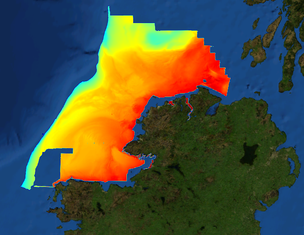
This composite Digital Terrain Model (cDTM) is a high resolution bathymetry dataset highlighting measurement of depth of water in the ocean. This cDTM covers the North Atlantic Ocean off the coast of County Donegal in Ireland. The EMODnet high resolution DTM covers bathymetry surveys completed between 2002 and 2016. Bathymetric data collected on board research vessels using multi-beam and single-beam echosounder instrumentation. Raw bathymetry processed within CARIS software to produce bathymetry products subsequently converted to NetCDF cDTM for EMODnet. Acquisition, processing and product delivery follows IHO standard s44 Edition 5. cDTM is composed of eighteen (18) images “merged simply” using GLOBE software. INFOMAR (Integrated Mapping for the Sustainable Development of Ireland’s Marine Resource) is a twenty year programme to map the physical, chemical and biological features of Ireland’s seabed established in 2006. INFOMAR is funded by the Department of Communications, Climate Action and Environment (DCCAE), and delivered by joint management partners Geological Survey Ireland and the Marine Institute. The programme is the successor to the Irish National Seabed Survey (INSS) which ran between 1999 and 2005. INFOMAR concentrates on creating integrated mapping products related to the seabed.
-
Confidence in the classification of substrate type in the 2023 EUSeaMap broad-scale predictive habitat map for the Caspian region. Values are on a range from 1 to 3 (1=low confidence, 2=medium confidence, 3=high confidence). Substrate type is one of the layers of information used to categorise physical habitat types in EUSeaMap; these layers of information are collectively known as 'habitat descriptors'. The substrate layer confidence was obtained from reclassification and standardisation of the confidence scores associated with each primary layer used to create the Substrate types layer.
-
Classified seabed substrate types for European seas. Produced by EMODnet Seabed Habitats as an input layer for the 2023 EUSeaMap broad-scale habitat model for the Caspian region, based on a combination of EMODnet Geology seabed substrate products and biological substrates extracted form individual habitat maps from surveys around European seas. The extent of the mapped area includes the Caspian sea. The layer of seabed substrate was produced using data from EMODnet geology at the following scales: 1:10k, 1:500k, 1:1m, 1:5m (updated in 2023). The seabed substrate include: Rock and other hard substrata Coarse substrate Mixed sediment Sand Muddy Sand Sandy Mud Mud Bottoms dominated by Mytilaster lineatus and Amphibalanus improvisus Bottoms dominated by Dreissena grimmi Biological substrates were included in the 2023 version of EUSeaMap to assist in the classification of biogenic habitats. A bespoke classification of benthic broad habitat types was developed as part of EMODnet Seabed Habitats.
-
Classified seabed substrate types for European seas. Produced by EMODnet Seabed Habitats as an input layer for the 2021 EUSeaMap broad-scale habitat model, based on a combination of EMODnet Geology seabed substrate products and biological substrates extracted form individual habitat maps from surveys around European seas. The extent of the mapped area includes the Mediterranean Sea, Black Sea, Baltic Sea, and areas of the North Eastern Atlantic extending from the Canary Islands in the south to the Barents Sea in the north. The layer of seabed substrate was produced using data from EMODnet geology at the following scales: - 1:25k, 1:30k, 1:45k, 1:60k, 1:70k (a new fine scale layer as of 2021) - 1:50k 1:100k,1:250k (these were updated for 2021) - 1:1M (not updated for 2021) Biological substrates were included in the 2021 version of EUSeaMap to assist in the classification of biogenic habitats for the 2019 version of EUNIS. The Folk 5 classification of substrate is adopted because it is compatible with both the 2007-11 and 2019 versions of EUNIS, both of which have been applied in EUSeaMap 2021. A report on the methods used in the 2021 version of EUSeaMap (Vasquez et al., 2021) and reports on previous versions (v2016 and V2019) are linked in Online Resources.
-
Confidence in the classification of substrate type in the 2021 EUSeaMap broad-scale predictive habitat map. Values are on a range from 1 (Low confidence) to 3 (High confidence). Substrate type is one of the layers of information used to categorise physical habitat types in EUSeaMap; these layers of information are collectively known as 'habitat descriptors'. The substrate layer confidence was obtained from reclassification and standardisation of the confidence scores associated with each primary layer used to create the Substrate types layer. A report on the methods used in the 2021 version of EUSeaMap (Vasquez et al., 2021) and reports on previous versions (v2016 and V2019) are linked in Online Resources.
-
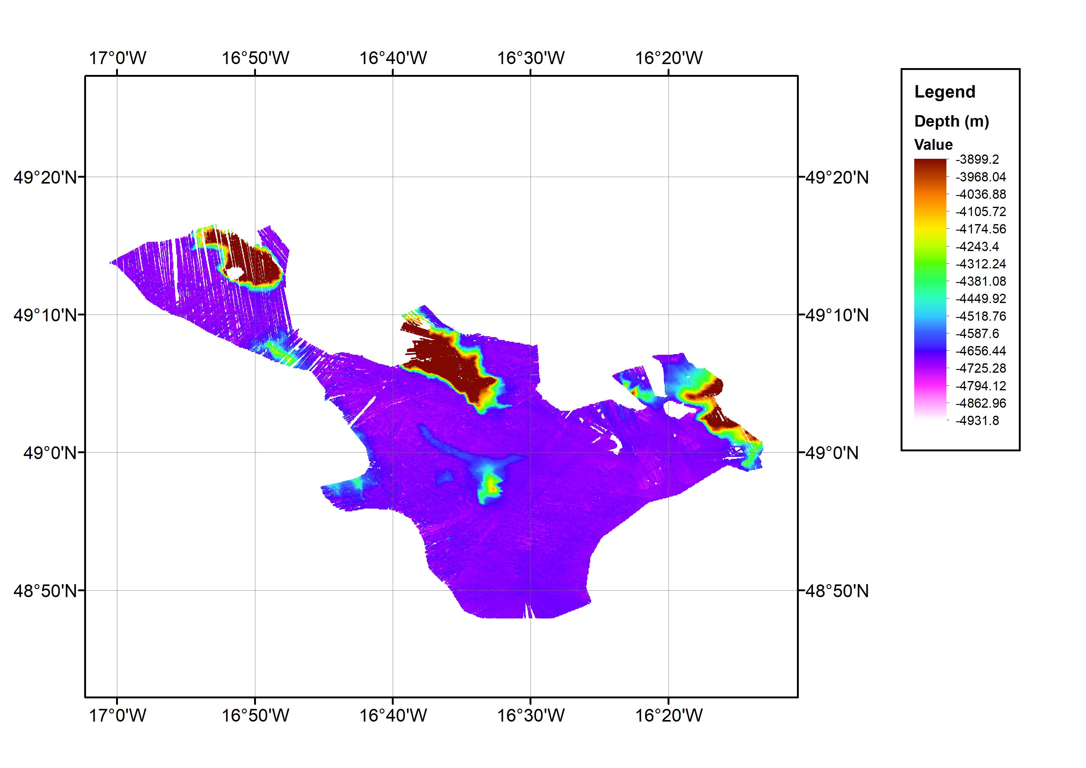
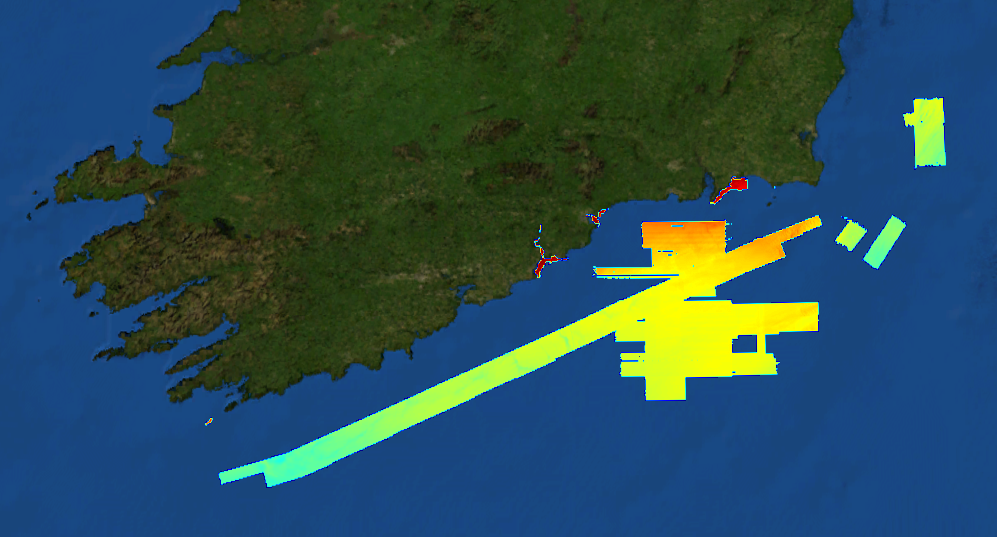
This data set consists of a bathymetric grid derived from multibeam bathymetry data from cruise JC071. The bathymetric grid was created by gridding cleaned raw multibeam data from JC071 at 1/64 arc-minute intervals. The data set covers an approximate one degree square with the minimum and maximum longitude and latitude co-ordinates: 17.016667W-16.216667W; 48.78333N-49.28333N. This is located in the Northeast Atlantic Ocean area. The data were collected from 7th-8th May 2012 using an EM120 Multibeam Echo-sounder. The cruise was part of the Porcupine Abyssal Plain (PAP): sustained ocean observation project. The bathymetry data were collected on an opportunistic basis during the cruise. The cruise was operated by the National Oceanography Centre (NOC), equipment operated by National Marine Facilities Sea Systems. The bathymetric grid was created by BODC for contributing to the EMODnet HRSM Project.
-
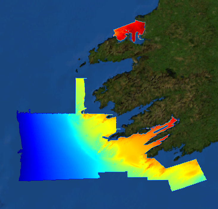
This composite Digital Terrain Model (cDTM) is a high resolution bathymetry dataset highlighting measurement of depth of water in the ocean. This cDTM covers the North Atlantic Ocean off the southwest coast of Ireland. The EMODnet high resolution DTM covers bathymetry surveys completed between 2002 and 2016. Bathymetric data collected on board research vessels using multi-beam and single-beam echosounder instrumentation. Raw bathymetry processed within CARIS software to produce bathymetry products subsequently converted to NetCDF cDTM for EMODnet. Acquisition, processing and product delivery follows IHO standard s44 Edition 5. cDTM is composed of nine (9) images “merged simply” using GLOBE software. INFOMAR (Integrated Mapping for the Sustainable Development of Ireland’s Marine Resource) is a twenty year programme to map the physical, chemical and biological features of Ireland’s seabed established in 2006. INFOMAR is funded by the Department of Communications, Climate Action and Environment (DCCAE), and delivered by joint management partners Geological Survey Ireland and the Marine Institute. The programme is the successor to the Irish National Seabed Survey (INSS) which ran between 1999 and 2005. INFOMAR concentrates on creating integrated mapping products related to the seabed.
-
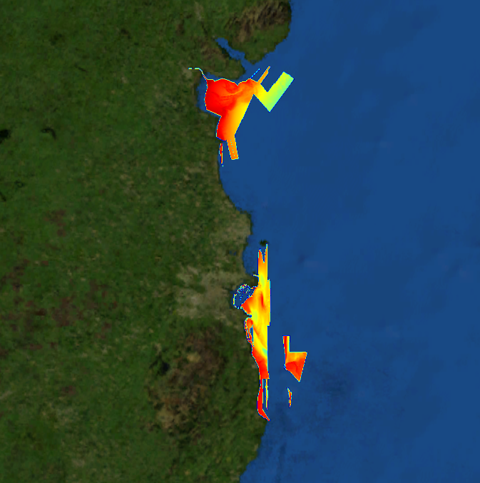
This composite Digital Terrain Model (cDTM) is a high resolution bathymetry dataset highlighting measurement of depth of water in the ocean. This cDTM covers the Irish Sea off the coasts of counties Wicklow and Louth in Ireland. The EMODnet high resolution DTM covers bathymetry surveys completed between 2002 and 2016. Bathymetric data collected on board research vessels using multi-beam and single-beam echosounder instrumentation. Raw bathymetry processed within CARIS software to produce bathymetry products subsequently converted to NetCDF cDTM for EMODnet. Acquisition, processing and product delivery follows IHO standard s44 Edition 5. cDTM is composed of seven (7) images “merged simply” using GLOBE software. INFOMAR (Integrated Mapping for the Sustainable Development of Ireland’s Marine Resource) is a twenty year programme to map the physical, chemical and biological features of Ireland’s seabed established in 2006. INFOMAR is funded by the Department of Communications, Climate Action and Environment (DCCAE), and delivered by joint management partners Geological Survey Ireland and the Marine Institute. The programme is the successor to the Irish National Seabed Survey (INSS) which ran between 1999 and 2005. INFOMAR concentrates on creating integrated mapping products related to the seabed.
-
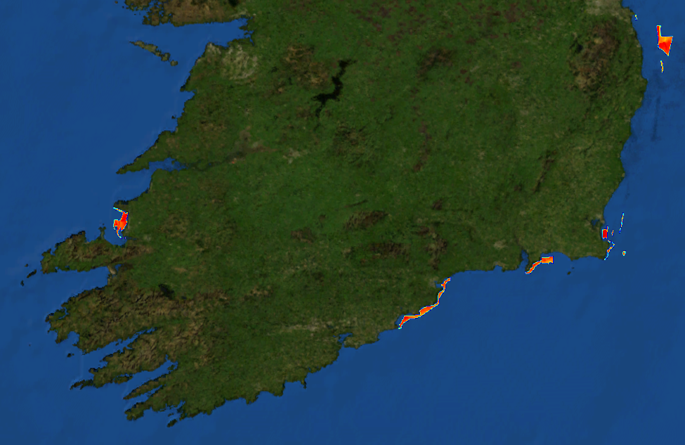
This composite Digital Terrain Model (cDTM) is a high resolution bathymetry dataset highlighting measurement of depth of water in the ocean. This cDTM covers the Celtic Sea off the coasts of counties Kerry, Cork and Wexford in Ireland. The EMODnet high resolution DTM covers bathymetry surveys completed between 2002 and 2016. Bathymetric data collected on board research vessels using multi-beam and single-beam echosounder instrumentation. Raw bathymetry processed within CARIS software to produce bathymetry products subsequently converted to NetCDF cDTM for EMODnet. Acquisition, processing and product delivery follows IHO standard s44 Edition 5. cDTM is composed of five (5) images “merged simply” using GLOBE software. INFOMAR (Integrated Mapping for the Sustainable Development of Ireland’s Marine Resource) is a twenty year programme to map the physical, chemical and biological features of Ireland’s seabed established in 2006. INFOMAR is funded by the Department of Communications, Climate Action and Environment (DCCAE), and delivered by joint management partners Geological Survey Ireland and the Marine Institute. The programme is the successor to the Irish National Seabed Survey (INSS) which ran between 1999 and 2005. INFOMAR concentrates on creating integrated mapping products related to the seabed.
-
This composite Digital Terrain Model (cDTM) is a high resolution bathymetry dataset highlighting measurement of depth of water in the ocean. This cDTM covers the Celtic Sea off the coast of counties Cork and Waterford in Ireland. The EMODnet high resolution DTM covers bathymetry surveys completed between 2002 and 2016. Bathymetric data collected on board research vessels using multi-beam and single-beam echosounder instrumentation. Raw bathymetry processed within CARIS software to produce bathymetry products subsequently converted to NetCDF cDTM for EMODnet. Acquisition, processing and product delivery follows IHO standard s44 Edition 5. cDTM is composed of eighteen (18) images “merged simply” using GLOBE software. INFOMAR (Integrated Mapping for the Sustainable Development of Ireland’s Marine Resource) is a twenty year programme to map the physical, chemical and biological features of Ireland’s seabed established in 2006. INFOMAR is funded by the Department of Communications, Climate Action and Environment (DCCAE), and delivered by joint management partners Geological Survey Ireland and the Marine Institute. The programme is the successor to the Irish National Seabed Survey (INSS) which ran between 1999 and 2005. INFOMAR concentrates on creating integrated mapping products related to the seabed.