 EMODnet Product Catalogue
Economy
Type of resources
Available actions
Topics
Keywords
Contact for the resource
Provided by
Years
Formats
Representation types
Scale 1:
Resolution
-
The dataset on fishing quotas by Fishery Management Zones (FMZs) was created in 2024 by Cogea for the European Marine Observation and Data Network (EMODnet). It is based on DG MARE's data and it is available for viewing and download on EMODnet web portal (Human Activities, https://emodnet.ec.europa.eu/en/human-activities). Total allowable catches (TACs), as Initial Quantity and Adapted Quota, are catch limits (expressed in tonnes) provided for each fish species (code and name) for a given year. Each stock is associated with one FMZ, but a FMZ can have multiple Stocks associated with it. Each species+area combination (stock) has multiple quota values per year. Quota values of the level'TAC' represent total allowable catch (sum of EU and third countries’ quotas). 'EEC' is the EU quota, which is the sum of individual Member States’ quotas. Thus in visualising the values of the quotas, the level needs to be taken into account. For many stocks, there is no value in the quota table. This means that the stock is defined only for reporting purposes, but there is no limitation of the amount of allowable catches. Due to the amount of data, all the attributes are not shown in the mapviewer, thus it is recommended to download the data in order to access to all the available info. The dataset is updated yearly and it covers a time series from 2012 onwards.
-

The dataset on fishing effort in the EU waters was created in 2020 by Cogea for the European Marine Observation and Data Network (EMODnet). It is updated every year and is available for viewing and download on the EMODnet web portal (Human Activities, https://emodnet.ec.europa.eu/en/human-activities). The dataset is the result of the elaboration of the 'STECF 22-06 - EU Fleet Economic and Transversal data_fleet segment (Version 1.1)' of the Scientific, Technical and Economic Committee for Fisheries (STECF) of the EU Commission (JRC). Aggregated STECF data have been related to georeferenced FAO's fishing statistical areas (27, 34 and 37, at all levels) and to Geographical subareas (GSAs) of the FAO's General Fisheries Commission for the Mediterranean (GFCM). Where and when available, data on Days at sea, Fishing days, Gross Tonnage fishing days, kW fishing days are provided for each FAO fishing statistical area and GSA by year of reference, Country, fishing technology and vessel length classes. With this update the dataset covers now a time series from 2008 to 2021.
-
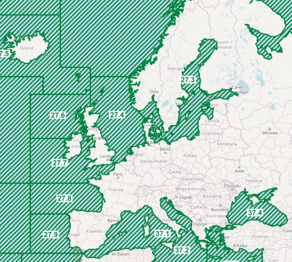
The datasets on fishing intensity in the EU waters by sea basin are created every year by the International Council for the Exploration of the Sea (ICES). In the 2020 Cogea started to collect and harmonize them according to the EMOdnet Human Activities dataset schema. The EMODnet dataset is updated yearly, as soon as new data from ICES Fishing Overviews are released, and is available for viewing and download on the EMODnet web portal (Human Activities, https://emodnet.ec.europa.eu/en/human-activities). Where and when available, the fisheries overview fishing intensity data concern: i) the spatial distribution of average annual fishing effort (mW fishing hours) by ecoregion (Azores, Bay of Biscay and the Iberian Coast, Baltic Sea, Barents Sea, Celtic Seas, Faroes, Greater North Sea, Icelandic Waters, Norwegian Sea and Oceanic Northeast Atlantic) and by gear type (Beam trawls, Bottom otter trawls, Bottom seines, Dredges, Pelagic trawls and seines, Static gears). Fishing effort data are only shown for vessels >12 m having vessel monitoring systems (VMS); ii) the average annual subsurface (top) and surface (bottom) mobile bottom contacting fishing gear (i.e. bottom otter trawls, bottom seines, dredges, beam trawls) disturbance by ecoregion in the Bay of Biscay and the Iberian Coast, Baltic Sea, Barents Sea, Celtic Seas, Faroes, Greater North Sea, Icelandic Waters, Norwegian Sea and Oceanic Northeast Atlantic, expressed as average swept-area ratios (SAR). Due to data confidentiality issues, VMS/logbook data are anonymized and aggregated in a 0.05×0.05 degree grid prior to submission to ICES, using the C-squares geocode system (polygons). The last data loaded into the database, from the ICES 2024 Fishing Overview update or revision (where available), report the 2019-2022 averages. Historical data area also included in the database, starting from the 2020 fishing overview, and reporting the 2015-2018, 2017-2020, 2018-2021, and 2019-2020 averages.
-
This dataset stems from the Joint Research Centre (JRC) Biomass Mandate (https://knowledge4policy.ec.europa.eu/projects-activities/jrc-biomass-mandate_en) and it is available for viewing and download on EMODnet web portal (Human Activities, https://emodnet.ec.europa.eu/en/human-activities) and on the platform from the European Commission’s Knowledge Centre for Bioeconomy (https://knowledge4policy.ec.europa.eu/visualisation/bioeconomy-different-countries_en#algae_prod_plants). The dataset provides information on the location (geographic coordinates and country) of the production facilities and their related info as the group of produced organism (macroalgae, microalgae and spirulina), the step in the value chain (Producer, Processor, Technology provider, Consultancy, Research and Development, Trader/Exporter) the production method (Fermenters, Harvesting , Photobioreactors, Open ponds, Semi Open ponds, land-based or at sea Aquaculture, Integrated multi-trophic or not) and the species farmed (see dataset). The data have been collected for the following countries: Austria, Belgium, Bulgaria, Croatia, Czech Republic, Denmark, Estonia, Faroe Islands, France, Germany, Greece, Greenland, Hungary, Iceland, Ireland, Italy, Latvia, the Netherlands, Norway, Portugal, Spain, Sweden, Switzerland and the United Kingdom. The JRC, through a study commissioned for the Knowledge Centre for Bioeconomy in September 2022, has updated the database with the latest information and extended the scope to new socio-economic data, which are made available as a dataset collection (https://publications.jrc.ec.europa.eu/repository/handle/JRC129053) and an accompanying report (https://publications.jrc.ec.europa.eu/repository/handle/JRC130107). More detailed information on the Status of the Algae Producing Industry in Europe can be found in a scientific publication in Frontiers in Marine Science (https://publications.jrc.ec.europa.eu/repository/handle/JRC122250). All this work by the JRC aims at building a reliable database to characterize the algae sector and to support informed European policies on Blue Growth and Bioeconomy.
-
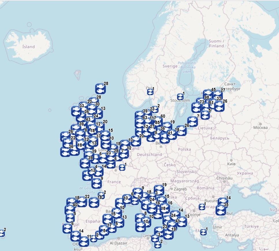
The dataset on first sales of fish in the European markets was created in 2016 by Cogea for the European Marine Observation and Data Network (EMODnet). The dataset is updated twice a year and it is available for viewing and download on EMODnet web portal (Human Activities, https://emodnet.ec.europa.eu/en/human-activities). The dataset originates from the monthly first sales of fish data made available by the European Market Observatory for Fisheries and Aquaculture products (EUMOFA). The EUMOFA is a fully-fledged observatory, but it is also a work in progress and its coverage is constantly revised by adding or removing locations and species. EUMOFA data have been related to the fish markets locations (points) made available in DG MARE's Master Data Register, revised when necessary according to the United Nations Code for Trade and Transport Locations database (UN/LOCODE) and according to the EUROSTAT/GISCO dataset on main ports locations. Volume (net weight in kg), value (Euro) and price (Euro/kg) data are provided for each fish species in each place of sale by year, month, Commodity Group (CG), Main Commercial Species (MCS), EU's Electronic recording and reporting system (ERS) name, size category (according to AnnexII of Council R. 2406/96), preservation state and presentation state (aggregated by group and disaggregated by presentation type). The geographic coverage of available data is: Belgium, Bulgaria, Cyprus, Estonia, France, Germany, Greece, Italy, Latvia, Lithuania, Netherlands, Norway, Poland, Portugal, Spain, Sweden and the UK. It covers a time series from 2003 to 2023, where available. Compared with the previous version, this new version of the dataset includes an update to July 2023 (for the countries which sent their data to EUMOFA).
-
The dataset on fish catches in the European waters by FAO statistical areas was created in 2015 by Cogea for the European Marine Observation and Data Network (EMODnet). It is the result of the aggregation of EUROSTAT's fish catches datasets fish_ca_atl 27, fish_ca_atl 34, fish_ca_atl 37, fish_ca_atl271, fish_ca_atl272, fish_ca_atl34_h and fish_ca_atl37_h. It is available for viewing and download on EMODnet web portal (Human Activities, https://emodnet.ec.europa.eu/en/human-activities). EUROSTAT data have been related to FAO's georeferenced fishing areas (polygons) for statisticl purposes (FAO, 2020. FAO Statistical Areas for Fishery Purposes. In: FAO Fisheries and Aquaculture Department). Tonnes live weight is provided for each fish species caught (3-alpha code and english or scientific name if the english one is not available), by EUMOFA's larger aggregations such as EUMOFA's Commodity Groups and Main Commercial Species (see 'Species_Eumofa_ASFIS_2023' table), by year of reference and country (code and name). The dataset is updated yearly and it covers a time series from 1950 to 2021, where available. Compared with the previous version this new one's schema have been updated.
-
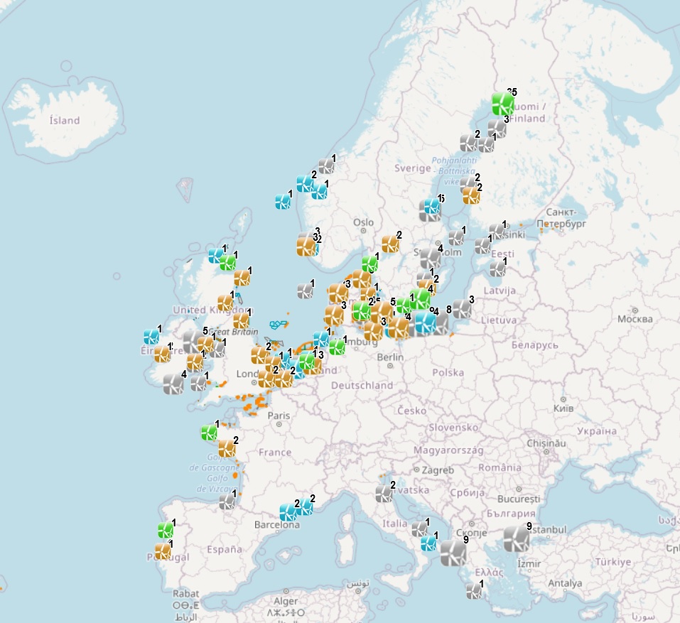
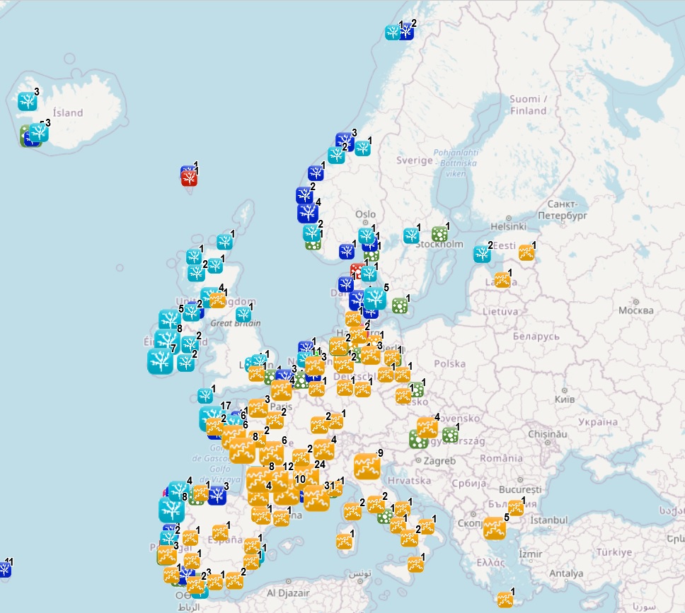
The dataset on offshore wind farms in the European seas was created in 2014 by CETMAR for the European Marine Observation and Data Network (EMODnet). It is the result of the aggregation and harmonization of datasets provided by several sources. It is updated every year and it is available for viewing and download on EMODnet web portal (Human Activities, https://emodnet.ec.europa.eu/en/human-activities). The dataset contains points and/or (where available) polygons representing offshore wind farms in the following countries: Belgium, Denmark, Estonia, Finland, France, Germany, Greece, Ireland, Italy, Latvia, Lithuania, Netherlands, Norway, Poland, Portugal, Spain, Sweden and United Kingdom. Each point and polygon has the following attributes (where available): Name, Nº of turbines, Status (Approved, Planned, Dismantled, Construction, Production, Test site), Country, Year, Power (MW), Distance to coast (metres) and Area (square kilometres). The distance to coast (EEA coastline shapefile) has been calculated using the UTM WGS84 Zone projected coordinate system where data fall in.