 EMODnet Product Catalogue
fishery
Type of resources
Available actions
Topics
Keywords
Contact for the resource
Provided by
Years
Formats
Representation types
Scale 1:
-
The dataset on marine finfish aquaculture in the EU was created in 2017 by AND-International for the European Marine Observation and Data Network (EMODnet). The dataset provides information about the location of marine finfish farms in the EU and partner countries where data are available. There is an obligation for EU MS to inventory all authorized aquaculture sites under the Council Directive 2006/88/EC on animal health requirements. Despite this obligation, the availability of data varies among MS from no data available at all to a complete regularly updated dataset. As far as partner countries are concerned, data have been collected only in Norway and the UK (Scotland only), where detailed data are provided online. Data provided here cover Cyprus, Denmark, Estonia, Finland, Greece, Ireland, Malta, Norway, Spain and the United Kingdom (Scotland only). Data collection is still undergoing in other EU MS and neighbouring countries. Each point has the following attributes (where available): Country, Owner name, Status (Active, n.a.), Farm type (Salmonids, Flatfish, Seabass-seabream and other coastal fish, Tuna, Other, n.a.), Production method (Sea cages, Saltwater tanks/raceways, Saltwater ponds, Saltwater closed (recirculation), Quarantine, Other, n.a.), Production stage (Grow out for human consumption, Hatchery, Nursery, Broodstock, Reproduction, Restoration of wild stock, Put and take fisheries, Processing facility, Slaughtering facility, Research facility, Sea ranching, Other, n.a.), Purpose (Commercial, Display, Education, Research, Capture-based aquaculture, Fishing park, Other, n.a.), Species_source (detailed information on species names as presented in the source and translated to English), Point information (Polygon centroid, Original) depending on how the information is provided in the source (polygons or points), Site_ID, the distance to coast (in meters), the position from Coastline (At sea or Within the coastline), the ID from the source to facilitate traceability, and the year the data was updated in the source. The farm type relies on a typology established by AND-International, based on available information on species grown. A relational table provides harmonised information about species grown using Eurostat nomenclature for the Species Group, the species name (commercial and scientific) and the Eurostat code (ALPHA-3 code for species). The data has been updated for all countries available and additional fields were added to improve traceability (ID from source and Year updated in the source). Data from Spain are available for viewing but not for download. Data from other countries are available for viewing and download.
-
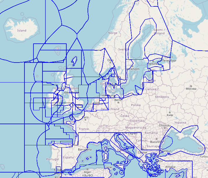
The dataset on fishing quotas by Fishery Management Zones (FMZs) was created in 2024 by Cogea for the European Marine Observation and Data Network (EMODnet). It is based on DG MARE's data and it is available for viewing and download on EMODnet web portal (Human Activities, https://emodnet.ec.europa.eu/en/human-activities). Total allowable catches (TACs), as Initial Quantity and Adapted Quota, are catch limits (expressed in tonnes) provided for each fish species (code and name) for a given year. Each stock is associated with one FMZ, but a FMZ can have multiple Stocks associated with it. Each species+area combination (stock) has multiple quota values per year. Quota values of the level'TAC' represent total allowable catch (sum of EU and third countries’ quotas). 'EEC' is the EU quota, which is the sum of individual Member States’ quotas. Thus in visualising the values of the quotas, the level needs to be taken into account. For many stocks, there is no value in the quota table. This means that the stock is defined only for reporting purposes, but there is no limitation of the amount of allowable catches. Due to the amount of data, all the attributes are not shown in the mapviewer, thus it is recommended to download the data in order to access to all the available info. The dataset is updated yearly and it covers a time series from 2012 onwards.
-
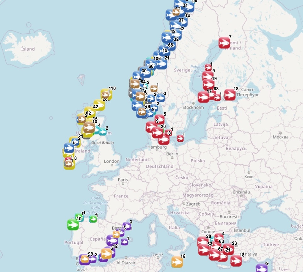
The dataset on licensed sites of shellfish aquaculture in the EU was created in 2023 by AND-International for the European Marine Observation and Data Network (EMODnet). It is the result of the aggregation and harmonization of datasets provided by national sources representing the delimitation of shellfish farms (polygons) in the following countries: France, Ireland and Spain. Data from France and Spain comes from national and regional cadastral data, while data from Ireland comes from the list of registered aquaculture sites. Each polygon has the following attributes (where available): country, expiration date, farm type (Mussels, Oysters, Mussels-Oysters, Clams, Specialised (other), Mixed (other)), species from the source (English translation of the information provided on species grown or authorised in the source), production method (Beds, Long lines, Rafts, Saltwater closed (recirculation), Saltwater ponds, Saltwater tanks/raceways, Trestles or trays, Bouchot, On-bottom, Sea cages, Other), production stage (Broodstock, Grow out for human consumption, Harvest, Hatchery, Nursery, Reproduction, Wild capture of seeds, Purification, Maturing, Other), purpose (only specified for some sites authorised for research purposes), polygon information (Lines to Polygon or Original) depending on how the information is provided in the source (polygons or lines), site_id, year updated (in the source), shape length and shape area. The farm type relies on a typology established by AND-International, based on available information on species grown or authorised. A relational table provides harmonised information about species grown or authorised using Eurostat nomenclature for the Species Group (Mussels; Oysters; Clams, cockles, arkshells; Scallops, pectens; Abalones, winkles, conchs; Sea-urchins and other echinoderms) and when available the species name (e.g. Blue mussels - Mytilus edulis). Data are available for viewing and download on EMODnet - Human Activities web portal ( https://emodnet.ec.europa.eu/en/human-activities), except for the data from Spain, which are available in the viewer, but not for download.
-

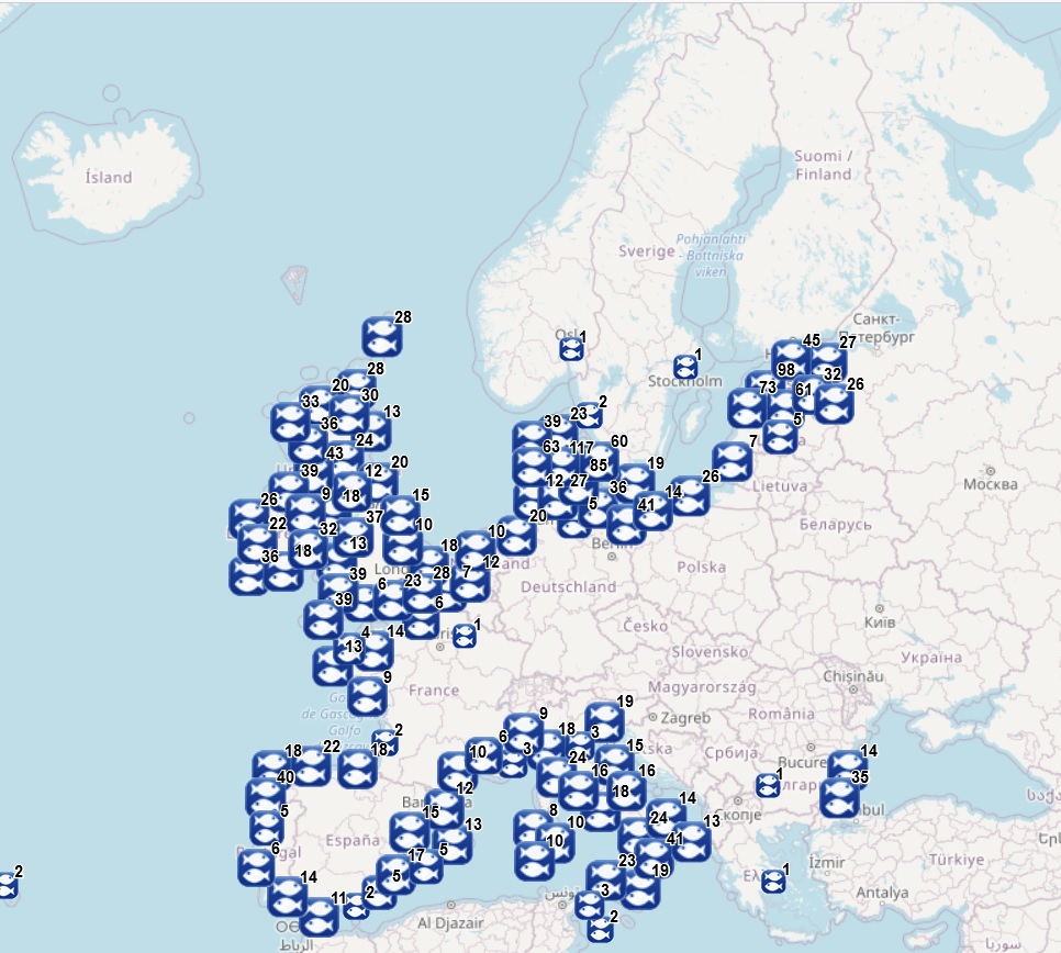
The dataset on fishing effort in the EU waters was created in 2020 by Cogea for the European Marine Observation and Data Network (EMODnet). It is updated every year and is available for viewing and download on the EMODnet web portal (Human Activities, https://emodnet.ec.europa.eu/en/human-activities). The dataset is the result of the elaboration of the 'STECF 22-06 - EU Fleet Economic and Transversal data_fleet segment (Version 1.1)' of the Scientific, Technical and Economic Committee for Fisheries (STECF) of the EU Commission (JRC). Aggregated STECF data have been related to georeferenced FAO's fishing statistical areas (27, 34 and 37, at all levels) and to Geographical subareas (GSAs) of the FAO's General Fisheries Commission for the Mediterranean (GFCM). Where and when available, data on Days at sea, Fishing days, Gross Tonnage fishing days, kW fishing days are provided for each FAO fishing statistical area and GSA by year of reference, Country, fishing technology and vessel length classes. With this update the dataset covers now a time series from 2008 to 2021.
-
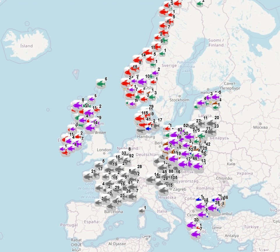
The dataset on freshwater aquaculture in the European countries was created in 2017 by AND-International for the European Marine Observation and Data Network (EMODnet). The dataset provides information about the location of freshwater finfish farms in the EU and partner countries where data are available. It is available for viewing and download on EMODnet web portal (Human Activities, https://emodnet.ec.europa.eu/en/human-activities). For EU MSs, it relies mainly on data collected under the Regulation (EU) 2016/429 (the ‘Animal Health Law’). As far as partner countries are concerned, data have been collected in Norway and in the UK (Scotland only), where detailed data are provided online. Data provided here cover Austria, Belgium, Bulgaria, Czechia, Denmark, Estonia, France, Greece, Ireland, Lithuania, Norway, Poland, Slovenia, Spain, and the UK (Scotland only). Each point has the following attributes (where available): status (Active, Expired, Inactive, Renewal), country, owner name, farm type (Carp, Diversified pond fish, Eel, Other diversified, Other specialised, Salmonids, Sturgeon, Trout), production method (Closed systems - recirculation, Ponds, Tanks/Raceways, Cages/Enclosures/Pens, Quarantine facility, Research facility, Other), production stage (Grow out for human consumption, Hatchery, Nursery, Brood stock, Put and take fisheries, Restoration of wild stock, Processing facility, Other), purpose (Commercial, Restocking, Other), Species from Source (English translation of the information provided on species grown in the source), point information (Polygon centroid, Original) depending on how the information is provided in the source (polygons or points), site_id and source_id (id from the source where available). The farm type relies on a typology established by AND-International, based on available information on species grown. A relational table provides harmonised information about species grown using Eurostat nomenclature for the Species Group (Carps, barbels and other cyprinids; Miscellaneous freshwater fishes; River eels; Salmons, trouts, smelts; Sturgeons, paddlefishes; Tilapias and other cichlids), the species name (commercial and scientific) and the code. Data have been updated for Austria, Czechia, Denmark, Estonia, Ireland, Lithuania, Norway, Poland, Slovenia, and the United Kingdom. Data from Spain have been added.
-
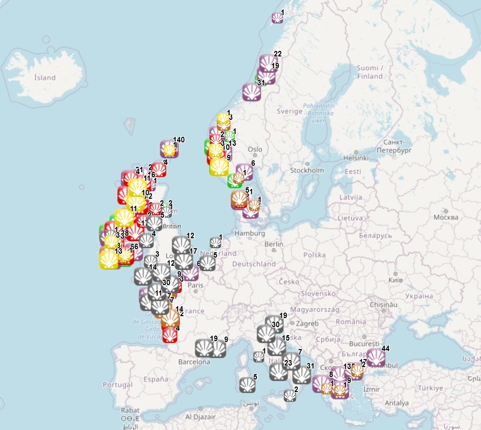
The dataset on shellfish aquaculture in the Eropean seas was created in 2014 by AND-International for the European Marine Observation and Data Network (EMODnet). It is the result of the aggregation and harmonization of datasets provided by national sources across the EU (plus Norway and the UK) and by the project Euroshell. The dataset contains points representing shellfish farms or shellfish production areas (depending on available data) in the following countries: Bulgaria, Denmark, France, Greece, Ireland, Italy, Netherlands, Norway, Slovenia, Spain and United Kingdom. Data from Bulgaria, Denmark, Greece, Ireland, Norway, Spain and Scotland come from the official lists of registered aquaculture sites. Data from France relies on cadastral data. Data from the Netherlands, Italy and England and Wales come from the Euroshell project. Data is missing for Germany, Portugal, Sweden and Croatia. Except for Germany, the shellfish production remains limited in those MS. There is no production in other MS. Each point has the following attributes (where available): status (active, inactive, licensed), country, owner name, farm type (Mussels, Oysters, Mussels-Oysters, Clams, Specialised (other), Mixed (other)), production method (Beds, Long lines, Rafts, Saltwater closed (recirculation), Saltwater ponds, Saltwater tanks/raceways, Trestles or trays, Other), production stage (Grow out for human consumption, Hatchery, Nursery, Broodstock, Reproduction, Harvest, Other), purpose (Commercial, Research, Education, Display, Other), products detailed (English translation of the information provided on species grown or authorised in the source), point information (Polygon centroid, Original) depending on how the information is provided in the source (polygons or points), site_id, distance to coast (metres), position from coastline (At sea, within the coastline). The farm type relies on a typology established by AND-International, based on available information on species grown or authorised. A relational table provides harmonised information about species grown or authorised using Eurostat nomenclature for the Species Group (Mussels; Oysters; Clams, cockles, arkshells; Scallops, pectens; Abalones, winkles, conchs; Sea-urchins and other echinoderms) and when available the species name (e.g. Blue mussels - Mytilus edulis). The distance to coast (EEA coastline shapefile) has been calculated using the original data map projections, where available. In the other cases it was used the UTM WGS84 Zone projected coordinate system where data fall in. Compared with the previous version this new version includes updated data for Denmark, Greece, Ireland, Norway and Scotland and new data from Slovenia and Spain. Data are available for viewing and download on EMODnet - Human Activities web portal (https://emodnet.ec.europa.eu/en/human-activities), except for the data from Spain, which are available in the viewer, but not for download.
-
The dataset on first sales of fish in the European markets was created in 2016 by Cogea for the European Marine Observation and Data Network (EMODnet). The dataset is updated twice a year and it is available for viewing and download on EMODnet web portal (Human Activities, https://emodnet.ec.europa.eu/en/human-activities). The dataset originates from the monthly first sales of fish data made available by the European Market Observatory for Fisheries and Aquaculture products (EUMOFA). The EUMOFA is a fully-fledged observatory, but it is also a work in progress and its coverage is constantly revised by adding or removing locations and species. EUMOFA data have been related to the fish markets locations (points) made available in DG MARE's Master Data Register, revised when necessary according to the United Nations Code for Trade and Transport Locations database (UN/LOCODE) and according to the EUROSTAT/GISCO dataset on main ports locations. Volume (net weight in kg), value (Euro) and price (Euro/kg) data are provided for each fish species in each place of sale by year, month, Commodity Group (CG), Main Commercial Species (MCS), EU's Electronic recording and reporting system (ERS) name, size category (according to AnnexII of Council R. 2406/96), preservation state and presentation state (aggregated by group and disaggregated by presentation type). The geographic coverage of available data is: Belgium, Bulgaria, Cyprus, Estonia, France, Germany, Greece, Italy, Latvia, Lithuania, Netherlands, Norway, Poland, Portugal, Spain, Sweden and the UK. It covers a time series from 2003 to 2023, where available. Compared with the previous version, this new version of the dataset includes an update to July 2023 (for the countries which sent their data to EUMOFA).
-
The dataset on fish catches in the European waters by FAO statistical areas was created in 2015 by Cogea for the European Marine Observation and Data Network (EMODnet). It is the result of the aggregation of EUROSTAT's fish catches datasets fish_ca_atl 27, fish_ca_atl 34, fish_ca_atl 37, fish_ca_atl271, fish_ca_atl272, fish_ca_atl34_h and fish_ca_atl37_h. It is available for viewing and download on EMODnet web portal (Human Activities, https://emodnet.ec.europa.eu/en/human-activities). EUROSTAT data have been related to FAO's georeferenced fishing areas (polygons) for statisticl purposes (FAO, 2020. FAO Statistical Areas for Fishery Purposes. In: FAO Fisheries and Aquaculture Department). Tonnes live weight is provided for each fish species caught (3-alpha code and english or scientific name if the english one is not available), by EUMOFA's larger aggregations such as EUMOFA's Commodity Groups and Main Commercial Species (see 'Species_Eumofa_ASFIS_2023' table), by year of reference and country (code and name). The dataset is updated yearly and it covers a time series from 1950 to 2021, where available. Compared with the previous version this new one's schema have been updated.
-
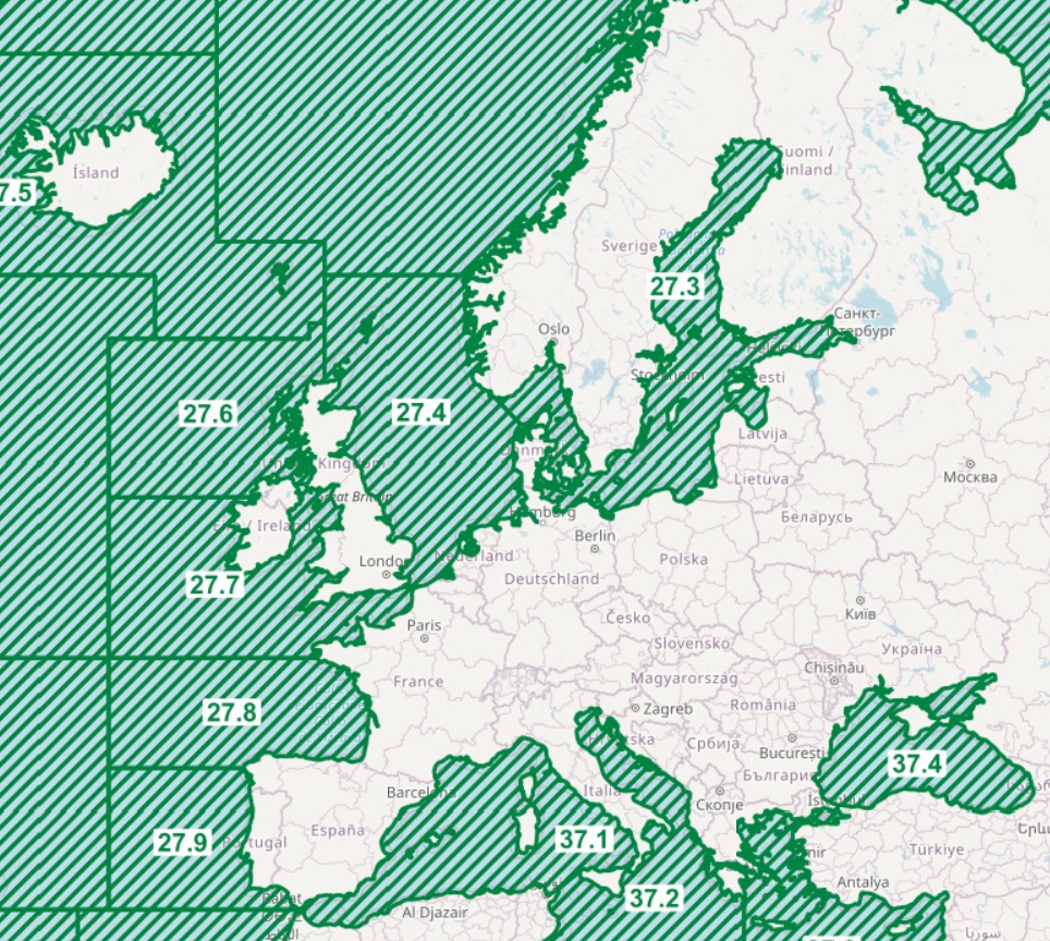
FAO Major Fishing Areas for Statistical Purposes are arbitrary areas, the boundaries of which were determined in consultation with international fishery agencies on various considerations, including (i) the boundary of natural regions and the natural divisions of oceans and seas; (ii) the boundaries of adjacent statistical fisheries bodies already established in inter-governmental conventions and treaties; (iii) existing national practices; (iv) national boundaries; (v) the longitude and latitude grid system; (vi) the distribution of the aquatic fauna; and (vii) the distribution of the resources and the environmental conditions within an area. The rationale of the FAO Major Fishing Areas has been that the areas should, as far as possible, coincide with the areas of competence of other fishery commissions when existing. This system facilitates comparison of data, and improves the possibilities of cooperation in statistical matters in general.
-
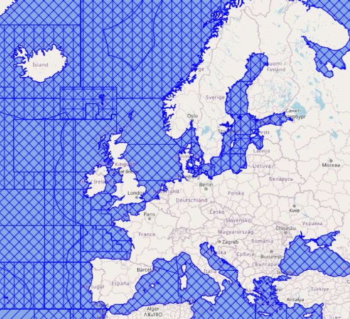
The ICES Statistical Areas delineates the divisions and subdivisions of FAO Major Fishing area 27. The ICES Statistical Areas are used as bounding areas for calculation of fish statistics, e.g. catch per unit effort (CPUE) and stock estimates.