 EMODnet Product Catalogue
boundaries
Type of resources
Available actions
Topics
Keywords
Contact for the resource
Provided by
Years
Formats
Representation types
Update frequencies
status
Scale 1:
-

EMODnet Physics - PSAL_002 - near real time salinity in the water column from multi platforms observations. The product presents the latest 7, 60 days and 12 months of measurements from fixed and moving platforms.
-
EMODnet Physics - TSM_BalticSea - Concentration of total suspended matter (conc_tsm, mg/l) is a product of the Coastcolour L2W Concentrations Data, obtained from the OC4 algorithm for clear and moderate turbid waters, and from the CoastColour v1 neural network.The L2W product was then remapped on a regular grid, maintaining the 300 m full resolution, in order to obtain L3 products over the Baltic Sea and monthly averaged. Developed by EMODnet Physics.
-
Read the abstract and supplemental information provided in the Vector template for more details.
-
Global mapped climatologies of temperature using the Data Interpolating Variational Analysis (DIVA) mapping method. This product covers all ocean basins over the years 1972 to 2013, and provides vertically interpolated data onto 33 standard depth surfaces, and gridded by bin averaging in each 1° × 1° grid cell. This product is based on the GLODAP (Global Ocean Data Analysis Project) dataset v2.2016b, built with surface-to-bottom ocean biogeochemical bottle data
-

Operational in situ river outflow data. The product includes near real time data from European river stations.
-
In situ data for global winds at sea/ground level. This product provides the user with in situ data of the last 60 days. Wind speed is presented in false-colour.
-
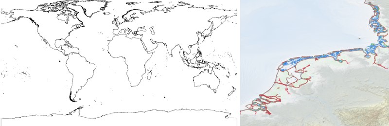
The EMODnet Bathymetry World Coastline is available as a WFS service from EMODnet Bathymetry. The service URL is: https://ows.emodnet-bathymetry.eu/wfs. The layer contains vector lines derived from land polygons available from OpenStreetMap. The original source url is https://osmdata.openstreetmap.de/. Parts of these polygons have been modified for use in EMODnet Bathymetry. In addition to the OSM EMODnet default coastline, three sub-layers are available as part of the EMODnet world coastline service. These sub-layers contain the best-estimate coastlines for Europe determined by Dutch research institute Deltares from satellite data (typically Sentinel-2 and Landsat-8) and in combination with the Global Tide Surge Model (GTSM) processed into digital coastlines for the European seas at LAT (Lowest Astronomical Tide), MSL (Mean-Sea-Level), and MHW (Mean-High-Water). The level of detail is bound to the resolution of the satellite sensor (e.g. 10m for Sentinel-2). The latest 2024 version covers the entire coastline of Europe and now also part of the Caribbean. A detailed paper is available describing the methodology used to determine the three versions of the satellite derived coastline: https://emodnet.ec.europa.eu/sites/emodnet.ec.europa.eu/files/public/EMODnet_Bathymetry_2024-satellite_derived_coastline_report_Deltares_Feb2025.pdf
-

EMODnet Physics - TEMP_002 - Near real-time temperature of the water column from multi-platform observations. The product presents the latest 7, 60 days and 12 months of measurements from fixed and moving platforms.
-

The EMODnet Bathymetry World Coastline is available as a WFS service from EMODnet Bathymetry. The service URL is: https://ows.emodnet-bathymetry.eu/wfs. The layer contains vector lines derived from land polygons available from OpenStreetMap. The original source url is https://osmdata.openstreetmap.de/. Parts of these polygons have been modified for use in EMODnet Bathymetry. In addition to the OSM EMODnet default coastline, three sub-layers are available as part of the EMODnet world coastline service. These sub-layers contain the best-estimate coastlines for Europe determined by Dutch research institute Deltares from satellite data (typically Sentinel-2 and Landsat-8) and in combination with the Global Tide Surge Model (GTSM) processed into digital coastlines for the European seas at LAT (Lowest Astronomical Tide), MSL (Mean-Sea-Level), and MHW (Mean-High-Water). The level of detail is bound to the resolution of the satellite sensor (e.g. 10m for Sentinel-2). The latest December 2022 version covers the entire coastline of Europe and now also part of the Caribbean. A detailed paper is available describing the methodology used to determine the three versions of the satellite derived coastline: https://emodnet.ec.europa.eu/sites/emodnet.ec.europa.eu/files/public/EMODnet-Bathymetry_2022_satellite_derived_coastlines_Deltares-Feb2023.pdf
-
In Situ Relative Sea Level Trends. Trend is presented by means of false color arrows. This product (developed for EMODnet Physics) uses the Permanent Service for Mean Sea Level (PSMSL) data bank on sea level data from the global network of tide gauges since 1900. The trend is available for stations with at least 30 years of measurements.