 EMODnet Product Catalogue
Benthos
Type of resources
Available actions
Topics
Keywords
Contact for the resource
Provided by
Years
Formats
Representation types
Update frequencies
status
Scale 1:
-
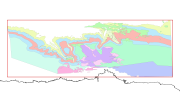
Raster showing the photosynthetic active radiation (PAR) reaching the seabed, values in mol.phot.m^-2.d^-1. Derived by multiplying the fraction of surface light reaching the seabed by the amount of light at the sea surface. Layer created for use in the 2019 EUSeaMap, and updated in 2018 in order to cover Iceland and the Barents Sea. Dataset's spatial extent covers European Seas including the Azores and Canary Islands, but excluding the eastern Baltic. Created by the EMODnet Seabed Habitats consortium using data from the European Space Agency MERIS instrument.
-
Raster showing a qualitative assessment of confidence in the photosynthetic active radiation (PAR) reaching the seabed, values in mol.phot.m^-2.d^-1. Values are on a range from 1 (Low confidence) to 3 (High confidence). Layer created for use in the 2019 EUSeaMap, and updated in 2018 in order to cover Iceland and the Barents Sea Datasets spatial extent covers European Seas including the Azores and Canary Islands, but excluding the eastern Baltic. The method used to calculate this layer is described in Section 10.1.2 (part of the Confidence Appendix) of Populus et al (2016). EUSeaMap A European broad-scale seabed habitat map Final Report.
-
Raster showing the photosynthetic active radiation (PAR) reaching the seabed, values in mol.phot.m^-2.d^-1. Derived by multiplying the fraction of surface light reaching the seabed by the amount of light at the sea surface. Layer created for use in the 2016 EU SeaMap. Datasets spatial extent covers European Seas including the Azores and Canary Islands, but excluding the eastern Baltic.
-
This dataset contains the habitats map from the SCI (Site of Community Importance) ÔÇ£Sistema de ca├▒ones submarinos de Avil├®sÔÇØ (Avil├®s Canyon System). The Avil├®s Canyon system is located in the eastern sector of the North Atlantic Ocean, on the continental margin to the north of the Iberian Peninsula. It is structurally a highly complex area, where the continental shelf in the Bay of Biscay is deeply affected by the action of tectonic compression, containing important geomorphological elements; these include: three great submarine canyons, a marginal platform and a tall structural rocky mass. This study was supported by the INDEMARES-LIFE+ Project, EC contract INDEMARES-LIFE+ (07/NAT/E/000732): Inventory and Designation of the Natura 2000 network in marine areas of the Spanish State (www.indemares.es/en). This work was coordinated by the Spanish Institute of Oceanography (IEO, www.ieo.es) and the Biodiversity Foundation (www.fundacion-biodiversidad.es). The interpretation has been made possible thanks to direct and indirect samplings and geophysical data from campaigns INDEMARES (AVILES_0710, AVILES_0410, AVILES_0412-0912). Habitats are classified according to EUNIS nomenclature and the List of Marine Habitats in Spain (LPRE, that itÔÇÖs classified hierarchically and was completed and published in March 2013).
-
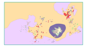
This dataset contains the main habitats maps from the SCI (Site of Community Importance) ÔÇ£Sur de Almer├¡a - Seco de los OlivosÔÇØ. Seco de los Olivos is a seamount situated in the Alboran Sea (western Mediterranean, southeast Iberian peninsula). This study was supported by the INDEMARES-LIFE+ Project, EC contract INDEMARES-LIFE+ (07/NAT/E/000732): Inventory and Designation of Marine Natura 2000 Network areas in the Spanish seas (www.indemares.es/en). This work was coordinated by the Spanish Institute of Oceanography (IEO, www.ieo.es) and the Biodiversity Foundation (www.fundacion-biodiversidad.es). The interpretation has been made possible thanks to direct and indirect samplings and geophysical data from campaigns ÔÇ£OCEANA I-2010ÔÇØ, ÔÇ£OCEANA II-2011ÔÇØ, ÔÇ£OCEANA III-2012ÔÇØ and ÔÇ£INDEMARES_SECO1012ÔÇØ. Habitats are classified according to EUNIS nomenclature and the List of Marine Habitats in Spain (LPRE, that itÔÇÖs classified hierarchically and was completed and published in March 2013).
-
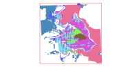
This dataset contains the main habitats maps from the SCI (Site of Community Importance) ÔÇ£Banco de GaliciaÔÇØ. The Galician Bank is a deep underwater mountain located at the northwest of the Iberian Peninsula, 180 km from the Galician coast (in the north-east Atlantic Ocean). Its summit is located at a depth of between 650 and 1,500 metres. Its steep slopes descend from the summit to the abyssal plains located 4,000 meters below sea level. This study was supported by the INDEMARES-LIFE+ Project, EC contract INDEMARES-LIFE+ (07/NAT/E/000732): Inventory and Designation of the Natura 2000 network in marine areas of the Spanish State (www.indemares.es/en). This work was coordinated by the Spanish Institute of Oceanography (IEO, www.ieo.es) and the Biodiversity Foundation (www.fundacion-biodiversidad.es). The interpretation has been made possible thanks to direct and indirect samplings and geophysical data from campaigns "ECOMARG09", "INDEMARES_BANGAL0810", "INDEMARES_BANGAL0711" and "RADPROF0912". Habitats are classified according to EUNIS nomenclature and the List of Marine Habitats in Spain (LPRE, that itÔÇÖs classified hierarchically and was completed and published in March 2013).
-
This dataset contains the habitats map from the SCI (Site of Community Importance) ÔÇ£Volcanes de fango del Golfo de C├ídizÔÇØ. The Gulf of Cadiz is located in the eastern sector of the North Atlantic Ocean, to the southwest of the Iberian Peninsula. Mud Volcanoes are seafloor edifices, of a usually conical geometry, that result from the release of mud, hydrocarbon and fluids in gas-rich areas over pressured sediments. This study was supported by the INDEMARES-LIFE+ Project, EC contract INDEMARES-LIFE+ (07/NAT/E/000732): Inventory and Designation of the Natura 2000 network in marine areas of the Spanish State (www.indemares.es/en). This work was coordinated by the Spanish Institute of Oceanography (IEO, www.ieo.es) and the Biodiversity Foundation (www.fundacion-biodiversidad.es). The interpretation has been made possible thanks to direct and indirect samplings and geophysical data from campaigns INDEMARES_CHICA (CHICA0610, CHICA0211, CHICA1011 and CHICA0412). Habitats are classified according to EUNIS nomenclature and the List of Marine Habitats in Spain (LPRE, that itÔÇÖs classified hierarchically and was completed and published in March 2013).
-
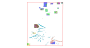
Map of the intertidal habitats in the Natura 2000 site FR5300017 - Aber Benoit, Aber Wrac'h