 EMODnet Product Catalogue
Habitat
Type of resources
Available actions
Topics
Keywords
Contact for the resource
Provided by
Years
Formats
Representation types
Update frequencies
status
Scale 1:
-
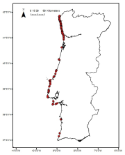
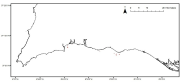
Cymodocea nodosa meadows distribution in the south of Portugal from historical data. Data provided by the Life Project BIOMARES and published in: ÔÇ£Seagrasses in Portugal: A most endangered marine habitatÔÇØ. Aquatic Botany. doi:10.1016/j.aquabot.2011.08.007. ÔÇ£Estimation of available seagrass meadows area in Portugal for transplanting purposes ÔÇØ. Journal of Coastal Research (2009) :SI 56 (1100-1104)
-
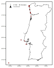
Laminaria ochroleuca distribution in the Portuguese mainland from historical data. Data provided by the Project FindKelp and published in: ÔÇ£Findkelp, a GIS-based Community Participation Project to Assess Portuguese Kelp Conservation StatusÔÇØ. Journal of Coastal Research (2009) :SI 56 (1469-1473)
-
Saccorhiza polyschides distribution in the Portuguese mainland from historical data. Data provided by the Project FindKelp and published in: ÔÇ£Findkelp, a GIS-based Community Participation Project to Assess Portuguese Kelp Conservation StatusÔÇØ. Journal of Coastal Research (2009) :SI 56 (1469-1473)
-
Zostera marina meadows distribution in the Portuguese mainland from historical data. Data provided by the Life Project BIOMARES and published in: ÔÇ£Seagrasses in Portugal: A most endangered marine habitatÔÇØ. Aquatic Botany. doi:10.1016/j.aquabot.2011.08.007. ÔÇ£Estimation of available seagrass meadows area in Portugal for transplanting purposes ÔÇØ. Journal of Coastal Research (2009) :SI 56 (1100-1104)
-
Zostera noltii meadows distribution in the Portuguese mainland from historical data. Data provided by the Life Project BIOMARES and published in: ÔÇ£Seagrasses in Portugal: A most endangered marine habitatÔÇØ. Aquatic Botany. doi:10.1016/j.aquabot.2011.08.007. ÔÇ£Estimation of available seagrass meadows area in Portugal for transplanting purposes ÔÇØ. Journal of Coastal Research (2009) :SI 56 (1100-1104)
-
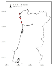
Laminaria hyperborea distribution in the Portuguese mainland from historical data. Data provided by the Project FindKelp and published in: ÔÇ£Findkelp, a GIS-based Community Participation Project to Assess Portuguese Kelp Conservation StatusÔÇØ. Journal of Coastal Research (2009) :SI 56 (1469-1473)
-
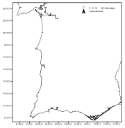
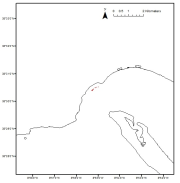
Maerl beds distribution in the Portuguese mainland from historical data. Data published in: ÔÇ£Present distribution of maerl beds in the Atlantic Iberian PeninsulaÔÇØ. Museologia Scientifica e Naturalista. Volume Speciale 2009
-
This dataset assembles historical information existing in public and private documentary archives. Taken together, these data contribute to the building of a knowledge base of the historical presence, extent and biogenic formations of European flat oyster ecosystems prior to and during the intensification of bottom fishing activities. To identify and recover such information requires significant resources and expertise. The establishment of a Historical Ecology Working Group under the umbrella of the Native Oyster Restoration Alliance in early 2020 presented a unique opportunity to coalesce interdisciplinary expertise and resources from multiple European countries to collate and interrogate historical data sources. To date, this is the only known dataset that evidences the past distribution, extent and characteristics of this seabed ecosystem across its full biogeographic range. The described datasets present qualitative and quantitative extracts from written records published between 1524-2022, which show: (1) estimated locations of past oyster fisheries and/or reef habitat across its full biogeographical range, with associated levels of confidence; (2) recorded extent of past reef habitats, and; (3) species associated with these habitats. This comprehensive historical analysis demonstrates that oyster reefs were once a dominant three-dimensional feature along much of the European coastline and some shallow shelf seas.
-
The dataset provides full-coverage maps of the habitats and biotopes in the German Baltic Sea at a resolution of 1 x 1 km for the entire region and at 50 x 50 m resolution in specific areas. We combined geological and biological surveys to map the seabed and collected extensive data to classify different habitats and their associated benthic communities. Using newly established national guidelines and predictive habitat modelling, we produced highly accurate maps. The maps show Broad and Other Habitat Types (including Habitats Directive Annex I habitat types) according to the Marine Strategy Framework Directive (MSFD) as well as HELCOM HUB biotope types. Detailed documentation is available at: https://doi.org/10.3390/biology13010006
-
The purpose of measuring jelly plankton in the marine environment is primarily to detect changes in the marine food web. The national monitoring program is financed by the Swedish Agency for Marine and Water Management. Monitoring is performed by Gothenburg University. Data are stored in the Swedish Ocean Archive (SHARK) by the Swedish Meteorological and Hydrological Institute (SMHI). Information about the program and the methods are available in Swedish at the website of Swedish Agency for Marine and Water Management, https://www.havochvatten.se/vagledning-foreskrifter-och-lagar/vagledningar/ovriga-vagledningar/overvakningsmanualer-for-miljoovervakning/overvakningsmanualer/geleplankton.html