 EMODnet Product Catalogue
Cogea srl
Type of resources
Available actions
Topics
Keywords
Contact for the resource
Provided by
Years
Formats
Representation types
Scale 1:
Resolution
-
The dataset on fishing quotas by Fishery Management Zones (FMZs) was created in 2024 by Cogea for the European Marine Observation and Data Network (EMODnet). It is based on DG MARE's data and it is available for viewing and download on EMODnet web portal (Human Activities, https://emodnet.ec.europa.eu/en/human-activities). Total allowable catches (TACs), as Initial Quantity and Adapted Quota, are catch limits (expressed in tonnes) provided for each fish species (code and name) for a given year. Each stock is associated with one FMZ, but a FMZ can have multiple Stocks associated with it. Each species+area combination (stock) has multiple quota values per year. Quota values of the level'TAC' represent total allowable catch (sum of EU and third countries’ quotas). 'EEC' is the EU quota, which is the sum of individual Member States’ quotas. Thus in visualising the values of the quotas, the level needs to be taken into account. For many stocks, there is no value in the quota table. This means that the stock is defined only for reporting purposes, but there is no limitation of the amount of allowable catches. Due to the amount of data, all the attributes are not shown in the mapviewer, thus it is recommended to download the data in order to access to all the available info. The dataset is updated yearly and it covers a time series from 2012 onwards.
-
The dataset on Marine Protected Areas (MPAs) established under the framework of the Regional Sea Conventions (RSCs) was created in 2023 by Cogea for the European Marine Observation and Data Network (EMODnet). It is based on spatial data provided by HELCOM (HELCOM_MPAs_2019_2), by SPA/RAC and MedPAN through the MAPAMED database (MAPAMED_SPAMI_2019_edition_version_2), and by OSPAR (OSPAR_MPAs_202107_001). It is available for viewing and download on EMODnet web portal (Human Activities, https://emodnet.ec.europa.eu/en/human-activities). The dataset displays all the MPAs as officially reported by the respective Contracting Parties to the Helsinky Convention, to the Barcelona Convention and to the Convention for the Protection of the Marine Environment of the North-East Atlantic. The RSCs MPAs are established in order to promote the cooperation in the management and conservation of natural areas, as well as in the protection of threatened species and their habitats. Each RSC MPA may be established in the marine and coastal zones subject to the sovereignty or jurisdiction of the Parties and in areas situated partly or wholly on the high sea. Thus, the dataset covers the MPAs Beyond National Jurisdiction (ABNJ) and the MPAs in following countries: Albania, Algeria, Belgium, Cyprus, Denmark, Estonia, Finland, France, Germany, Iceland, Ireland, Italy, Latvia, Lebanon, Lithuania, Monaco, Morocco, the Netherlands, Norway, Poland, Portugal, Russia, Slovenia, Spain, Sweden, Tunisia, and the United Kingdom. Where available each polygon has the following attributes: code, name (english and/or original), designation, country, status (adopted/designated, managed or partly managed, proposed), establishement year, area sqkm (reported, calculated), marine area sqkm (reported, calculated) management authorithy, site link. For further information please visit the data providers websites. This dataset covers the last updated versions in the 2021 and 2022.
-
The dataset on Emerald Network sites was created in 2023 by Cogea for the European Marine Observation and Data Network. It is entirely based on spatial data from the European Environmental Agency (EEA), plus additional infos and selected EEA tabular data added as feature attributes. It is available for viewing and download on EMODnet web portal (Human Activities, https://emodnet.ec.europa.eu/en/human-activities). The Emerald Network is an ecological network made up of Areas of Special Conservation Interest designated under Recommendation No. 16 (1989) and Resolution No. 3 (1996) of the Standing Committee to the Bern Convention. The objective of the Emerald Network is the long-term survival of the species and habitats. The Network involves all the European Union member States (the European Union contributes to the Emerald Network with its Natura 2000 sites), some non-Community States and a number of African States. The dataset cover the following countries: Albania, Andorra, Armenia, Azerbaijan, Belarus, Bosnia and Herzegovina, Georgia, Iceland, Liechtenstein, Moldova, Montenegro, North Macedonia, Norway, Russian Federation (European part), Serbia, Switzerland, Ukraine and the United Kingdom. In the webmap the dataset has been filtered in order to show only marine and coastal sites. Where available each polygon has the following attributes: site code, site name, country code, country name, site type/description (A: SPA, Special Protection Areas - sites designated under the Birds Directive; B: SCIs and SACs, Sites of Community Importance and Special Areas of Conservation - sites designated under the Habitats Directive; C: where SPAs and SCIs/SACs boundaries are identical, sites are designated under both directives), site status (Proposed, Candidate or Adopted), compilation date, update date, area (ha), marine area percentage, marine/coastal location (1). For further information (e.g. biogeographic region, designation status, sites, habitats, impact, management, species and metadata) please visit the EEA's website hosting the Emerald tabular data (https://www.eea.europa.eu/data-and-maps/data/emerald-network-data-1/emerald-tabular-data). This version covers the reporting in 2021.
-

The dataset on fishing effort in the EU waters was created in 2020 by Cogea for the European Marine Observation and Data Network (EMODnet). It is updated every year and is available for viewing and download on the EMODnet web portal (Human Activities, https://emodnet.ec.europa.eu/en/human-activities). The dataset is the result of the elaboration of the 'STECF 22-06 - EU Fleet Economic and Transversal data_fleet segment (Version 1.1)' of the Scientific, Technical and Economic Committee for Fisheries (STECF) of the EU Commission (JRC). Aggregated STECF data have been related to georeferenced FAO's fishing statistical areas (27, 34 and 37, at all levels) and to Geographical subareas (GSAs) of the FAO's General Fisheries Commission for the Mediterranean (GFCM). Where and when available, data on Days at sea, Fishing days, Gross Tonnage fishing days, kW fishing days are provided for each FAO fishing statistical area and GSA by year of reference, Country, fishing technology and vessel length classes. With this update the dataset covers now a time series from 2008 to 2021.
-
The dataset on coastal and marine protected areas in the European seas for those countries or territories that are not covered by the the EEA's Common Database on Designated Areas (CDDA) was created in 2022 by Cogea for the European Marine Observation and Data Network (EMODnet). This dataset is entirely based on GIS vector data from UNEP-WCMC and IUCN 2023, (Protected Planet: The World Database on Protected Areas, WDPA, [Online], September 2023, Cambridge, UK: UNEP-WCMC and IUCN, available at: www.protectedplanet.net), plus additional info and selected tabular data added as feature attributes, as well as the calculation of marine and coastal location of features. It is available for viewing and download on EMODnet web portal (Human Activities, https://emodnet.ec.europa.eu/en/human-activities). The WDPA is the most comprehensive global database of marine and terrestrial protected areas, it is a joint project between UN Environment Programme (UNEP) and the International Union for Conservation of Nature (IUCN), and it is managed by the UNEP World Conservation Monitoring Centre (UNEP-WCMC), in collaboration with governments, non-governmental organisations, academia and industry. In the webmap the dataset has been filtered in order to show only marine and coastal areas. Geographical coverage: Algeria, Antigua and Barbuda, Barbados, Belize, Colombia, Costa Rica, Cuba, Denmark (only the Faroe Islands), Dominica, Dominican Republic, Egypt, France (only Guadeloupe, Martinique, Saint Barthélemy, Saint Martin French part), Georgia, Grenada, Guatemala, Haiti, Honduras, Israel, Jamaica, Lebanon, Mexico, Monaco, Morocco, Netherlands (only Aruba, Curaçao, Bonaire, Sint Eustatius and Saba, Sint Maarten Dutch part) Nicaragua, Norway (only Svalbard and Jan Mayen), Palestine, Panama, Russian Federation, Saint Kitts and Nevis, Saint Lucia, Saint Vincent and the Grenadines, Trinidad and Tobago, Tunisia, Turkey, Ukraine, United Kingdom (including Anguilla, British Virgin Islands, Cayman Islands, Guernsey, Isle of Man, Jersey, Montserrat), United States (only Puerto Rico, the US Virgin Islands and the US Minor Outlying Islands in the Caribbean Sea), Venezuela. Where available each polygon has the following main attributes: country code, territory code, country name, territory name, WDPA ID, name (english and original), designation name (english and original) and type (International, National, Not Applicable, Regional), IUCN category and description (Ia: Strict Nature Reserve; Ib: Wilderness Area; II: National Park; III: Natural Monument or Feature; IV: Habitat/Species Management Area; V: Protected Landscape/ Seascape; VI: Protected area with sustainable use of natural resources; Not applicable; Not assigned; Not reported), marine location (1: predominantly marine; 2: entirely marine), area sqkm (reported, calculated), marine area sqkm (reported, calculated), status (Adopted, Designated, Established, Inscribed, Not Reported, Proposed), government type (Collaborative governance, Federal or national ministry or agency, For-profit organisations, Government-delegated management, Indigenous peoples, Individual landowners, Joint governance, Local communities, Non-profit organisations, Not Reported, Sub-national ministry or agency), ownership type (Communal, For-profit organisations, Individual landowners, Joint ownership, Multiple ownership, Non-profit organisations, Not Reported, State), management authorithy and plan info, marine/coastal location (1). For further information please visit the Protected Planet website. Compared with the previous release, this one includes the updated dataset 'WDPA_Sep2023_Public' published by the WDPA in September 2023 and it includes the marine and coastal protected areas in the Caribbean Sea.
-
The database on Desalination plants in the EU was created in 2021 by Cogea srl for the European Marine Observation and Data Network (EMODnet). It is the result of the harmonization of a dataset provided by GWI DesalData. The dataset provides spatial information (point) on the centroid of the municipality where a given plant is located. It is available for viewing and download on EMODnet - Human Activities web portal (https://emodnet.ec.europa.eu/en/human-activities) and will be updated every year. The dataset covers the following countries: Albania, Austria, Belgium, Belarus, Bosnia and Herzegovina, Bulgaria, Croatia, Cyprus, Czech Republic, Denmark, Finland, France, Georgia, Germany, Gibraltar, Greece, Guernsey, Hungary, Ireland, Italy, Jersey, Latvia, Liechtenstein, Lithuania, Luxembourg, Malta, Moldova, Netherlands, Norway, Poland, Portugal, Romania, Russia, Serbia, Slovakia, Slovenia, Spain, Sweden, Switzerland, Turkey, UK, Ukraine. Where available, each point has the following attributes: site code (ID), Location Name, Country, Position Source, Commune Name, NUTS code (NUTS 3 ID), Latitude, Longitude. A relational table provides further information for each desalination plant where data are available: Location Type, Project, Capacity (m3/d), Size, Units, Unit Size (m3/d), Technology, Feedwater, Plant Type, Award Date, Online Date, Plant Status, Customer Type, Industry Type, Customer, Holding Company, Plant Owner. More plant-specific information is available in the original dataset.
-
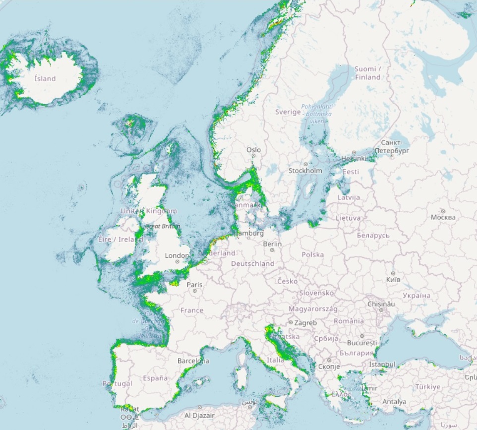
The datasets on fishing intensity in the EU waters by sea basin are created every year by the International Council for the Exploration of the Sea (ICES). In the 2020 Cogea started to collect and harmonize them according to the EMOdnet Human Activities dataset schema. The EMODnet dataset is updated yearly and as soon as new data from ICES are released, and is available for viewing and download on the EMODnet web portal (Human Activities, https://emodnet.ec.europa.eu/en/human-activities). Where and when available, the fisheries overview data concern: i) the spatial distribution of average annual fishing effort (mW fishing hours) by ecoregion (Azores, Bay of Biscay and the Iberian Coast, Baltic Sea, Barents Sea, Celtic Seas, Faroes, Greater North Sea, Icelandic Waters, Norwegian Sea and Oceanic Northeast Atlantic) and by gear type (Beam trawls, Bottom otter trawls, Bottom seines, Dredges, Pelagic trawls and seines, Static gears). Fishing effort data are only shown for vessels >12 m having vessel monitoring systems (VMS); ii) the average annual subsurface (top) and surface (bottom) mobile bottom contacting fishing gear (i.e. bottom otter trawls, bottom seines, dredges, beam trawls) disturbance by ecoregion in the Bay of Biscay and the Iberian Coast, Baltic Sea, Barents Sea, Celtic Seas, Faroes, Greater North Sea, Icelandic Waters, Norwegian Sea and Oceanic Northeast Atlantic, expressed as average swept-area ratios (SAR). Due to data confidentiality issues, VMS/logbook data are anonymized and aggregated in a 0.05×0.05 degree grid prior to submission to ICES, using the C-squares geocode system (polygons). The last data loaded into the database, from the ICES 2022 Fishing Overview, report the 2018-2021 averages. Compared with the previous one this new version has a new dataset schema and also historical data have been included in the database.
-
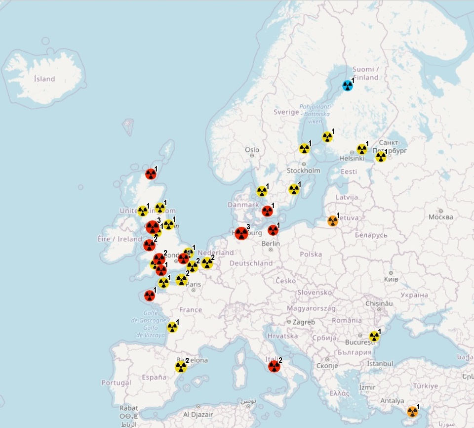
The geodatabase on coastal Nuclear Power Plants was created in 2019 by Cogea for the European Marine Observation and Data Network (EMODnet). It is the result of the aggregation and harmonization of datasets provided by several EU and non-EU sources. It is available for viewing and download on the EMODnet Human Activities web portal (https://emodnet.ec.europa.eu/en/human-activities). The geodatabase contains points representing nuclear power plants sites in the following countries: Belgium, Finland, France, Germany, Italy, Netherlands, Romania, Russia, Spain, Sweden, Turkey and UK. Where available each point has the following attributes: EMODnet Code, Plant Name, Country, Status (Operational, Permanently shut down, Planned, Under construction), Number of Reactors, Thermal Capacity (MW), Gross Capacity (MW), Net Capacity (MW), Location (Municipality), Water Source, Latitude, Longitude. Additional informations about reactors are stored in a separated table and are related to the point feature class. Where available for each reactor the following attributes are reported: EMODnet Code, Plant Name, Status (Operational, Permanently shut down, Planned, Under construction), Type, Model, Fuel Type, Thermal Capacity (MW), Gross Capacity (MW), Net Capacity (MW), Operator, Nuclear Steam Supply System (NSSS), Construction Year, Construction Month, Criticality Year, Criticality Month, Connection to the Grid Year, Connection to the Grid Month, Shut Down Year, Shut Down Month. The dataset will be updated every year.
-
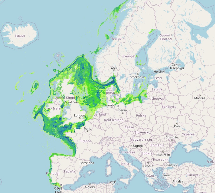
The Vessel Density maps in the EU are created since the 2019 by Cogea for the European Marine Observation and Data Network (EMODnet). The dataset is updated every year and is available for viewing and download on EMODnet web portal (Human Activities, https://emodnet.ec.europa.eu/en/human-activities). The maps are based on AIS data yearly purchased from Collecte Localisation Satellites (CLS) and ORBCOMM. The maps, GeoTIFF format, show shipping density in 1x1km cells of a grid covering all EU waters and some neighbouring areas. Density is expressed as hours per square kilometre per month. The following ship types are available:0 Other, 1 Fishing, 2 Service, 3 Dredging or underwater ops, 4 Sailing, 5 Pleasure Craft, 6 High speed craft, 7 Tug and towing, 8 Passenger, 9 Cargo, 10 Tanker, 11 Military and Law Enforcement, 12 Unknown and All ship types. Data are available by month of year. Yearly averages are also available.
-
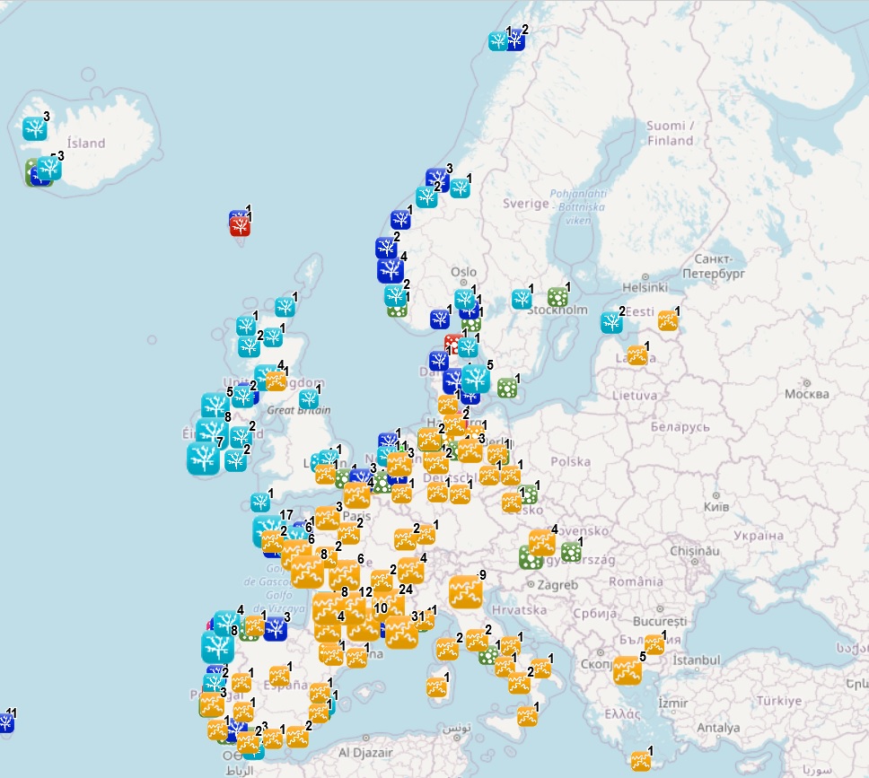
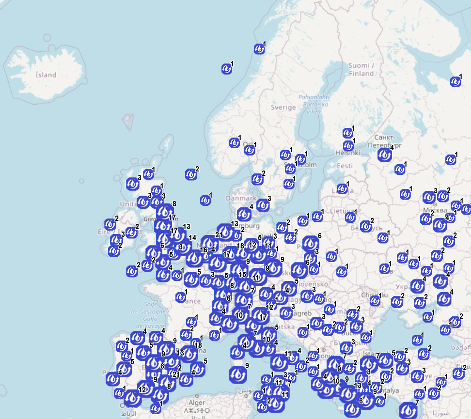
This dataset stems from the Joint Research Centre (JRC) Biomass Mandate (https://knowledge4policy.ec.europa.eu/projects-activities/jrc-biomass-mandate_en) and it is available for viewing and download on EMODnet web portal (Human Activities, https://emodnet.ec.europa.eu/en/human-activities) and on the platform from the European Commission’s Knowledge Centre for Bioeconomy (https://knowledge4policy.ec.europa.eu/visualisation/bioeconomy-different-countries_en#algae_prod_plants). The dataset provides information on the location (geographic coordinates and country) of the production facilities and their related info as the group of produced organism (macroalgae, microalgae and spirulina), the step in the value chain (Producer, Processor, Technology provider, Consultancy, Research and Development, Trader/Exporter) the production method (Fermenters, Harvesting , Photobioreactors, Open ponds, Semi Open ponds, land-based or at sea Aquaculture, Integrated multi-trophic or not) and the species farmed (see dataset). The data have been collected for the following countries: Austria, Belgium, Bulgaria, Croatia, Czech Republic, Denmark, Estonia, Faroe Islands, France, Germany, Greece, Greenland, Hungary, Iceland, Ireland, Italy, Latvia, the Netherlands, Norway, Portugal, Spain, Sweden, Switzerland and the United Kingdom. The JRC, through a study commissioned for the Knowledge Centre for Bioeconomy in September 2022, has updated the database with the latest information and extended the scope to new socio-economic data, which are made available as a dataset collection (https://publications.jrc.ec.europa.eu/repository/handle/JRC129053) and an accompanying report (https://publications.jrc.ec.europa.eu/repository/handle/JRC130107). More detailed information on the Status of the Algae Producing Industry in Europe can be found in a scientific publication in Frontiers in Marine Science (https://publications.jrc.ec.europa.eu/repository/handle/JRC122250). All this work by the JRC aims at building a reliable database to characterize the algae sector and to support informed European policies on Blue Growth and Bioeconomy.