EU-China Blue Partnership for the Ocean
Following high-level conferences and forums during the EU-China Blue Year 2017, the EU and China signed a Blue Partnership for the Ocean on the 16th of July 2018, which marked the beginning of a new phase of strategic EU-China ocean relations. This Partnership set out a comprehensive and holistic framework for our cooperation in the domain of the oceans. The shared objective of the Partnership was to ensure effective ocean governance for the conservation and sustainable use of the oceans and their resources. Key aims included sustainable fisheries, a thriving maritime economy, and healthy oceans and the resources they contain.
EMODnet Partnership for China and Europe (EMOD-PACE)
China-EU Marine Data Network Partnership (CEMDnet)
As a concrete step towards achieving these common Partnership objectives, both the EU and China had set-up two collaborative projects with a focus on marine data exchange and diplomacy, which were intricately connected:
-
The European funded EMOD-PACE (EMODnet PArtnership for China and Europe); and
-
The CEMDnet (China-EU Marine Data Network Partnership) - ‘中国-欧盟海洋数据网络伙伴关系’
The WMO_ICO Centre for Marine Meteorological and Oceanographic Climate Data (CMOC/China) is the executive of the CMOC/China and promotes its general interest.
EMODnet Partnership for China and Europe (EMOD-PACE)
EMOD-PACE (EMODnet PArtnership for China and Europe) was funded under the EU Partnership Instrument on 31 October 2019 (EuropeAid/139904/DH/SER/CN ‘Strengthening international ocean data through the EU’s ocean diplomacy with China’). The collaborative project with China aimed to promote international ocean governance and support the implementation of global commitments through closer collaboration between Europe and China. This was achieved by developing new information products, improving the sharing of marine observation data, marine expert knowledge and by establishing a close working relationship between the National Marine Data and Information Service of China (NMDIS) and the European Marine Observation Data Network (EMODnet). The objectives of the collaboration were to further our knowledge about the behaviour of the seas, assist those who are relying on high quality marine data and data products at global level, and to protect and sustainably manage the marine environment.
The EMOD-PACE project consisted of 18 European partner organisations. It officially started on 19 February 2020 and ran for a period of 34 months until 31 December 2022. The project delivered a major part of the EU contribution to the EU-China Blue Partnership for the Oceans.
China-EU Marine Data Network Partnership (CEMDnet) ‘中国-欧盟海洋数据网络伙伴关系’
In June 2017, during the EU China Blue Year Event - forecasting, data, monitoring, planning, indicators, National Marine Data and Information Service (NMDIS) of China put forward a cooperation initiative to build a China-EU Marine Big Data Center and promote marine data sharing and technical exchanges between the two sides. In July 2018, China and the European Union signed a unique ocean partnership agreement, Blue Partnership for the Oceans: Towards Better Ocean Governance. In September the same year, an EU delegation composed of representatives from EC Directorate-General for Maritime Affairs and Fisheries (DG MARE) and the Delegation of the European Union to China visited NMDIS in Tianjin. The two sides had productive talks and agreed on developing cooperation between China and the EU on marine data sharing and exchange, mutual study of marine data and information management and service standards, joint marine data products R&D and application, to jointly improve the social and economic efficiency of marine data management services, promote marine science and technology development, and contribute to global ocean conservation and climate change adaption.
In response to the EMOD-PACE at EU side, NMDIS started its work on developing the China-EU Marine Data Network Partnership (CEMDnet), which aimed at connecting the EMODnet and data sharing platform running by NMDIS, to facilitate marine data interoperability between EMODnet and NMDIS.
Meanwhile, EMODnet and NMDIS jointly worked on marine data and information management services, standards and product R&D in the fields of ocean reanalysis, seabed habitat mapping, ecological vulnerability and coastal zone adaptability, etc.
CEMDnet was officially launched in February 2020 for a period of 30 months. The implementation of the project made positive contributions to the China-EU Blue Partnership for the Oceans.
Background
Marine data sharing
The publication and sharing of marine data follows established best practice. The EU shares marine observation data through EMODnet and ocean modelling data through Copernicus Marine Service. In general, European marine observation data originates with the Member States, and is aggregated by EMODnet for publication on the EMODnet Portal as a centralised hub for European in situ marine data.
In China, NMDIS is responsible for national marine data collection, management, processing and distribution, and the construction and operation of the marine environmental and geographical information service platform, undertaking quality control and evaluation of marine data and information products. In addition, it is responsible for operational tide and tidal current forecast, sea level change prediction and evaluation and development and release of marine environment data re-analysis products.
Optimising data sharing and user access between EMODnet and NMDIS – the Challenge
Marine observations are fundamentally geospatial in nature. An observation consists of measurements associated with any particular parameter (temperature for example) at a location for a certain time. Each component of the observation can vary depending on standards used, for example:
- Temperature, Fahrenheit, Celsius and Kelvin are all valid measurements;
- Time can vary depending on local sunrise and sunset;
- Location description can be depending on the geospatial grid being used to describe the Earth.
Science can address some of these problems, for example, through the development of standardised units for measurement and by recording a universal time. Also, in general, the World Geodetic System (WGS84) is used as the reference coordinate system, but not always, and the geographic coordinate system (datum and projection) will vary depending on the region in the world, and also on the area being mapped.
The necessity to share scientific quality environmental data online for the support of research, policy formulation and implementation and others, has led to the realisation that observations need to be annotated by metadata (data that describes data), to provide more context to the observations. For example, who made the observation, what were the general weather conditions or what datum was the observation location made against.
With EMODnet, EU has gained considerable experience over the past decade with providing users access to a wide range of multidisciplinary datasets at European level by fostering interoperability of data collected and stored by different countries, institutes and thematic and regional data assembly initiatives.
The overall aim of the EMOD-PACE project was to promote international ocean governance with China and support the implementation of global commitments by making Ocean marine data and data products more easily accessible and by providing better data and data products. As such this project investigated ways to optimise data sharing and user access between EMODnet and NMDIS by investigating ways to improve interoperability between EMODnet geodata servers and NMDIS geodata servers. For example, the project investigated the suitability of the following aspects facilitating the exchange and interoperability of data from different sources:
- Open Geospatial Consortium web services;
- Metadata standards;
- File format standards.
The project delivered a searchable catalogue of EMODnet and NMDIS data that can be either downloaded or displayed in a web map. This catalogue exists in duplicate on both the EMODnet Portal and NMDIS portal.
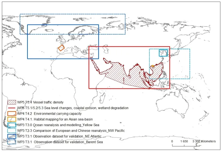
The geographical scope of EMOD-PACE
Project Partners
EMOD-PACE Consortium
| Role | Consortium Members | Nationality |
|---|---|---|
| Leader | Seascape Belgium bvba (SSBE) | Belgium |
| Member | Fundación AZTI – AZTI Fundazioa (AZTI) | Spain |
| Member | Fondazione Centro Euro-Mediterraneo sui Cambiamenti Climatici (CMCC) | Italy |
| Member | Consulenti per la Gestione Aziendale (COGEA) | Italy |
| Member | Stichting Deltares (Deltares) | The Netherlands |
| Member | Danmarks Meteorologiske Institut (DMI) | Denmark |
| Member | EOMAP GmbH & Co. KG (EOMAP) | Germany |
| Member | ETT S.p.A. (ETT) | Italy |
| Member | Geologian tutkimuskeskus (GTK) | Finland |
| Member | Hellenic Centre for Marine Research (HCMR) | Greece |
| Member | Institute français de recherché pour l’exploitation de la mer (IFREMER) | France |
| Member | Joint Nature Conservation Committee (JNCC) | UK |
| Member | Mariene Informatie Service BV (MARIS) | The Netherlands |
| Member | Istituto Nazionale di Oceangrafia e di Geofisica Sperimentale (OGS) | Italy |
| Member | Service Hydrographique et Océanographique de la Marine (SHOM) | France |
| Member | Swedish Meteorological and Hydrological Institute (SMHI) | Sweden |
| Member | Vlaams Instituut voor de Zee (VLIZ) | Belgium |
| Subcontractors | Bilbomatica S.A. | Spain |
| Subcontractors | Geological Survey of Denmark and Greenland (GEUS) | Denmark |
| Subcontractors | TNO | Netherlands |
*The European Commission inter-services Steering Committee is chaired by Directorate-General Maritime Affairs and Fisheries (DG MARE) and Foreign Policy Instruments.
National Marine Data and Information Service (NMDIS)

Communication
EMOD-PACE CEMDnet leaflet
Find more information in our project leaflet about the EMOD-PACE CEMDnet European Union and China Partnership for Marine Data.
News
Reports
- EMOD-PACE Deliverable 4.5 (6 MB) - May 2022: EMOD-PACE final report on the "Marine Resource-Environment Carrying Capacity and Spatial Development Suitability" approach application to Europe, showing the Bay of Biscay as an example". Short summary: Analysing the applicability of each sides models (i.e., the models used within Europe and China), by testing the European model for seabed habitats in Asian waters and the Chinese model for ecosystem vulnerability in European waters. This includes a description of the methodology used in the analysis.
- EMOD-PACE Deliverable 4.4 (3 MB) - December 2022: This report details the collaborative effort between partners from Europe and China to deliver the first broad-scale habitat map for a Chinese sea basin, using the EUNIS (European Nature Information System) approach. The case study site selected for this work covers part of the Beibu Gulf, located in the north-western parts of the South China Sea. Included is a summary of the methodology used, as well as a presentation of the habitat map, its input layers and associated confidence assessments. Furthermore, discussed are limitations of the approach, applicability to Chinese sea basins and proposed next steps to improve in this work.