EMODnet Bathymetry provides a service for viewing and downloading the best available harmonised Digital Terrain Model (DTM) for the European sea regions, together with a range of other bathymetric data, products, and services. The DTM is generated and regularly updated by the EMODnet Bathymetry partnership using an increasing number of bathymetric data sets. Services for discovery and requesting access to these data sets are provided and maintained as well.
Objectives
EMODnet Bathymetry aims to provide a single access point to bathymetric data (survey data sets and composite DTMs), and derived bathymetric data products such as best-estimate European digital coastlines, inventory of official coastlines and baselines, a series of high-resolution DTMs for selected areas, and the EMODnet Bathymetry World Base Layer OGC web service. Its flagship data product is the harmonised Digital Terrain Model (DTM) for all European sea regions with a common grid resolution which is generated and regularly updated on the basis of an increasing collection of bathymetric data sets, gathered from organisations from government, research institutes, and industry. This DTM is updated every 2 years and made available in the EMODnet Mapviewer, by OGC web services, and by downloading in multiple formats for use in GIS systems and as baselayer for numerical hydraulic models.
Approach
EMODnet Bathymetry is undertaken by a gradually expanding consortium of organisations from marine science, governmental departments, national hydrographic services, and industry. They combine expertises and experiences of collecting, processing, and managing of bathymetric data together with expertises in distributed data infrastructure development and operation and providing OGC services (WMS, WFS, and WCS) for viewing and distribution.
They bring together bathymetric data sets from in-situ surveys, composite DTMs, and Satellite Derived Bathymetry products, which are managed and described in INSPIRE compliant catalogue services, such as the SeaDataNet CDI data discovery and access service for survey data sets and the SeaDataNet Sextant catalogue for composite DTMs.
Moreover, an effective production workflow has been designed and deployed in accordance with international standards for generation and distribution of the EMODnet Digital Terrain Model (DTM) for all European sea regions and for referencing its input data sets. Survey data and Composite DTMs are pre-gridded and pre-processed to the required EMODnet grid, resolution and format by data providers, using the standard GLOBE software. This is followed by Regional Coordinators, each round upgrading Regional DTMs, and each supported by a regional group of data providers. They are responsible for a quality assessment and selection of the data contributions and the compilation of the Regional DTMs, again using GLOBE software. Gaps in data coverage are filled by using the GEBCO bathymetry model, while GEBCO in turn integrates the EMODnet DTM, which benefits both products. The RDTMs and QA-QC reports are forwarded to the integrator for building the overall EMODnet DTM. The integrator also performs a number of quality checks and measures, before making the new DTM release ready for publishing.
With multiple actors (data providers, regional coordinators, web/portal integrator, metadata curators) communication is at the heart of this methodology. Efficient communication is ensured between all these levels, based on commonly agreed concepts, methodologies, documentation, and software tools.
The EMODnet DTM is a major and highly popular data product as it is used for a whole range of applications in marine science, sustainable ocean governance, and blue economy activities such as planning of pipeline trajectories, locations of offshore wind farms or planning of harbour extensions. In science, the DTM supports oceanographers in providing a base geometry for hydrodynamic models, marine geologists for studying dynamic morphological processes, and biologists in contributing to the generation of seabed habitat maps. An improved DTM also contributes to reducing risks for damage to coastal and offshore installations and public safety by improving our ability to forecast storm surges for example.
In addition, to the flagship DTM product, EMODnet Bathymetry also produces and publishes best-estimate European digital coastlines, an inventory of official coastlines and baselines, a series of high-resolution DTMs for selected areas, and the EMODnet Bathymetry World Base Layer OGC web service, again with great attention for quality and involving hydrography experts from all of Europe.
Benefits
This structural and organizational approach has the following benefits:
- It facilitates the expansion of the geographical coverage to other seas.
- It facilitates the expansion of the pool of data sets used for the DTM productions with input from other data holders. Also, because possible existing data access restrictions can be respected, while internally the data sets are used in higher resolutions to enrich the DTM production;
- It facilitates to acknowledge data sources in the DTMs by standard metadata references in the SeaDataNet catalogue services, which are used for gathering bathymetric data sets from already more than 65 data providers. While, the SeaDataNet CDI service also facilitates requests for downloading of data sets by means of a shopping facility.
- All derived bathymetry products are made publicly available for browsing and downloading.
Products overview
Operational data discovery and viewing services for bathymetric data products (DTM layers) are provided to users since June 2011.
Layers/Data products
Users have access to the following geographical information system layers as part of the Mapviewer:
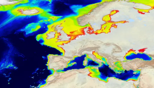
- Mean depth full coverage with water depth to Lowest Astronomical Tide (LAT) reference from EMODnet DTM in gridded form over whole of maritime basin on a grid of 1/16 * 1/16 arc minutes (ca. 115 metre grid) complemented by land DTM and GEBCO coverage in traditional atlas style colours.
- Mean depth in multi-color style with water depth to LAT reference from EMODnet DTM in gridded form over whole of maritime basin on a grid of 1/16 * 1/16 arc minutes (ca. 115 metre grid) complemented by GEBCO coverage but no land.
- Mean depth in rainbow colour style with water depth to LAT reference from EMODnet DTM in gridded form over whole of maritime basin on a grid of 1/16 * 1/16 arc minutes (ca. 115 metre grid) complemented by GEBCO coverage but no land.
- Source references is a layer which allows to identify the prevailing data sources used for each DTM grid cell. Activating the identification function in the sources layer will reveal for each DTM cell which survey data set or composite DTM was used with a link to their metadata from the CDI Data Discovery and Access service or Sextant Catalogue service. Grey areas are derived from GEBCO.
- Quality Index is an improved source reference layer with quality indication. Metadata has been expanded with characterization of the dataset by vertical, horizontal and temporal indicators, purpose of the survey, and information about commonly adopted standards. Analysis has resulted in extra maps with Quality Indicators for each source reference.
- High Resolution bathymetry is a multi-resolution layer which allows to view, zoom in, interrogate for metadata, and download of a collection of higher resolution composite DTMs (HR-DTMs) for selected areas. The resolution of HR-DTMs varies between 1/32 and 1/512 arc minutes, depending on local data policy of data providers.
- Survey tracks/polygons is another layer to view the locations and retrieve (CDI) metadata of the so far collated bathymetric survey data sets. Users can define a latitude(lat)/longitude(lon)box that will jump to the CDI Data Discovery and Access service for retrieving CDI metadata for the survey data sets within that geographical search window. This will then facilitate the users to refine their query and to request access to the high-resolution survey data sets themselves by means of a shopping mechanism.
- Land geography and topography as derived from OpenStreetMap.
- Geographic names on land is a customized layer of geographic names derived from Open Street Map.
- Displayed Coastlines are derived from OpenStreetMap 2024 WMS. It is a highly detailed coastline and a topographic representation. In addition, a dedicated task of EMODnet Bathymetry is to generate best-estimate coastlines (as interpreted from the intersections of know tidal levels and topography). These were determined from satellite data (typically Sentinel-2 and Landsat-8) and in combination with the Global Tide Surge Model (GTSM) processed into digital coastlines for the European seas at LAT (Lowest Astronomical Tide), MSL (Mean-Sea-Level), and MHW (Mean-High-Water). The level of detail is bound to the resolution of the satellite sensor (e.g. 10m for Sentinel-2). A first release was made in 2018, and updated releases every 2 years. The latest 2024 satellite derived coastlines can be viewed as extra layer in the Map Viewing service while reports with background information on each release since 2018 can be found in the EMODnet Reports Catalogue.
Furthermore, an inventory and report were compiled in 2018 and updated every 2 years with official baseline and coastline data as collected for 34 countries from national authorities and other sources in Europe. It describes the information available per country, the resolution, the source of the data and the institute providing/ hosting the data. Users can download the latest inventory and shapefiles of the baselines and coastlines. These reports can be found in the EMODnet Reports Catalogue. - Underwater features which is provided by the General Bathymetric Chart of the Oceans (GEBCO) as GEBCO Undersea Features WMS. The GEBCO Sub-Committee on Undersea Features (SCUFN) maintains and provides a gazetteer of the names, generic feature type and geographic positions of features on the seafloor. The level of detail is dependent on the viewing scale.
- Geographic map grid.
- EMODnet Bathymetry World Base Layer (EBWBL), generated in 2020, is a WMTS service providing a gridded representation of worldwide bathymetric and topographic coverage adapted for a better representation of seabed morphological features. It is composed of the 2018 EMODnet Bathymetric grid around Europe (approx. 115m resolution) and uses the GEBCO 2019 grid (approx. 500m resolution) elsewhere in the marine environment. Land coverage is based on a combination of 30 arc second Advanced Spaceborne Thermal Emission and Reflection Radiometer Global Digital Elevation Model (ASTER GDEM), Shuttle Radar Topography Mission3 (SRTM3 – 90m GDEM), EU-DEM (EU DEM based on ASTER and SRTM), and Global 1 (land DEM based on SRTM) second world-wide water body map for the topographic part. The compilation and void filling of the land DEM is based on the work of ViewFinderPanoramas.org . This global coverage layer will also be maintained in sync with the EMODnet DTM for Europe.
The EMODnet Bathymetry World Base Layer provides an easy-to-use facility for all GIS users or WebGIS designers to get access to the current highest resolved topographic and bathymetric world-wide layout. One can get access to it by following this link: tiles.emodnet-bathymetry.eu .
This site gives details about the WMTS Capabilities document and a Demo Viewer to try out a number of EMODnet DTM layers for Europe, the EBWBL for global coverage, and the various projections supported in the EBWBL WMTS service. The EBWBL layer has also been included in the layer menu of the Bathymetry Viewing and Download service.
The EBWBL service is available in non-projected coordinate system (Lat, Long, WGS84: EPSG 4326), Web Mercator (EPSG 3857), Inspire compliant ETRS-EALA projection (EPSG 3035) and projections adapted to both poles (ESPG 3031 and 3996).
All these layers are made available in the Central Map Viewing service and for many layers additional functionalities are offered such as depth profiles along user drawn transects, 3D viewing of the bathymetry in the browser, retrieving metadata of surveys, and downloading of DTM tiles and other data products.
Moreover, most map layers are also made available as OGC web services. More details are given at the Central Portal Webservices.
Further upgrading of the EMODnet DTM is planned and will include incorporating even more surveys and further improvement of the digital bathymetry. For this purpose, additional high resolution data sets are welcome and can be contributed using the EMODnet Ingestion service.
How to cite EMODnet Bathymetry products
EMODnet Digital Bathymetry (DTM 2024).
EMODnet Bathymetry Consortium
https://doi.org/10.12770/cf51df64-56f9-4a99-b1aa-36b8d7b743a1
EMODnet Digital Bathymetry (DTM 2024) - Tile Caribbean
EMODnet Bathymetry Consortium
https://doi.org/10.12770/cf51df64-56f9-4a99-b1aa-36b8d7b743a1
EMODnet Digital Bathymetry (DTM 2022).
EMODnet Bathymetry Consortium
https://doi.org/10.12770/ff3aff8a-cff1-44a3-a2c8-1910bf109f85
EMODnet Digital Bathymetry (DTM 2022) - Tile Caribbean
EMODnet Bathymetry Consortium
https://doi.org/10.12770/ff3aff8a-cff1-44a3-a2c8-1910bf109f85
EMODnet Bathymetry World Base Layer version 1.
GGS Geo Consultancy (2021): EMODnet Bathymetry consortium
https://doi.org/10.12770/386fe2aa-84c4-4cea-9e22-fcba4d5f2e75
EMODnet Bathymetry - World Coastline version 2022.
Deltares (2023): EMODnet Bathymetry consortium
https://doi.org/10.12770/36821cff-56db-4e96-8426-ddfe68240c4b
EMODnet Bathymetry - World Coastline version 2020.
Deltares (2021): EMODnet Bathymetry consortium
https://doi.org/10.12770/4a1dbf4b-e3f3-4983-aa54-a0379f984887
EMODnet Digital Bathymetry (DTM 2020).
EMODnet Bathymetry Consortium
https://doi.org/10.12770/bb6a87dd-e579-4036-abe1-e649cea9881a
EMODnet Digital Bathymetry (DTM 2018).
EMODnet Bathymetry Consortium
https://doi.org/10.12770/18ff0d48-b203-4a65-94a9-5fd8b0ec35f6
EMODnet Digital Bathymetry (DTM 2016).
EMODnet Bathymetry Consortium
https://doi.org/10.12770/c7b53704-999d-4721-b1a3-04ec60c87238
Geographic coverage
Bathymetric survey data sets are being catalogued as acquired and managed by European data providers for all regions in the world. The current 2024 release of the EMODnet Digital Terrain Model has a grid resolution of 1/16 * 1/16 arc minutes and covers the following European sea regions:
- the Greater North Sea,including the Kattegat and stretches of water such as Fair Isle, Cromarty, Forth, Forties,Dover, Wight, and Portland,
- the English Channel and Celtic Seas,
- Western Mediterranean, Ionian Sea and Central Mediterranean Sea,
- Iberi an Coast and Bay of Biscay (Atlantic Ocean),
- Adriatic Sea (Mediterranean),
- Aegean - Levantine Sea (Mediterranean),
- Madeira and Azores (Macaronesia),
- Baltic Sea,
- Black Sea,
- Norwegian and Icelandic Seas,
- Canary Islands (Macaronesia),
- European arctic region and Barentz Sea.
The geographic coverage of the EMODnet DTM for European sea regions is a Lat Lon box with 36W,15N; 43E,90N.
There is also a 2024 DTM release for part of the Caribbean Sea region, which is largely based upon in situ data contributions from European providers, complemented with Satellite Derived Bathymetry datasets and GEBCO input, and with a grid resolution of 1/16 * 1/16 arc minutes. Its geographic coverage is a Lat Lon box with 70W,11N; 60W,19N.
Vertical references
The bathymetric data as collected from the data providers, are supposed to be referenced at the Lowest Astronomical Tide (LAT) (International Hydrographic Office (IHO) resolution 3/1919) which is relevant for the vertical reference for nautical charts. Most Hydrographic Offices in Europe have adopted this IHO guideline. Therefore, the EMODnet Digital Terrain Model has been developed and is published for viewing and downloading in LAT.
Although IHO recommends LAT as the vertical reference for nautical charts, it is not an optimal vertical reference for several other applications such as hydrodynamical modelling near the coasts (tide, storm surge or waves). For this reason, efforts have been undertaken by EMODnet Bathymetry to enable converting the bathymetric model from LAT to MSL. Therefore, the following steps have been applied:
- Modelling of LAT with respect to MSL with a numerical tide model for Europe;
- Extending this, relatively coarse data, in very shallow and inter-tidal waters;
- Adding the LAT-MSL difference to the LAT-referenced gridded bathymetry.
The numerical tide model ‘Global Tide Surge Model (GTSM)’ as developed and run by Deltares (NL) has been used as a robust model. This model is a worldwide model which is based on an unstructured mesh with the mesh decreasing to 25km in the middle of the oceans to 1.25km along the coasts of Europe. This model has been forced by the most recent and publicly recognised bathymetric and topographic information (EMODnet Bathymetry DTM in Europe and GEBCO 2019 for the rest of the world), along with tide generating forces including amongst other winds and surface pressure. Also, the model has been extensively validated against tide measurements.
Using this method, the EMODNet DTM is also made available for downloading in MSL. This applies for the DTM tiles in the ESRI ASCII format, which are downloadable both in LAT and MSL.
QA/QC and DTM production details
Bathymetric survey data and aggregated bathymetry data sets have been collated from many data providers. These have been processed, quality controlled and used for the EMODnet DTM for European seas. The 2016 DTM version has a grid size of 1/8 * 1/8 arc minutes, while the 2018, 2020, 2022 and 2024 versions have an increased resolution of 1/16 * 1/16 arc minutes. Each grid cell has the following information:
- x, y coordinates;
- minimum water depth in metres to LAT;
- average water depth in metres to LAT;
- maximum water depth in metres to LAT;
- standard deviation of water depth in metres;
- number of values used for interpolation over the grid cell;
- interpolation flag (identification of extrapolated cells);
- average water depth smoothed by means of a spline function in metres to LAT;
- an indicator of the offsets between the average and smoothed water depth as a % of the water depth;
- reference to the prevailing source of data with metadata.
Note: The water depth values are in metres with reference to LAT.
The DTM values have been determined from 4 possible sources of data:
- Bathymetric survey data = high resolution data sets from single and multibeam surveys that are referenced via the CDI Data Discovery and Access service.
- Digital Terrain Model data = composite data sets produced and delivered by a number of external data providers such as Hydrographic Offices derived from their internal bathymetric database and based upon historic surveys. The aggregated data sets are referenced in the source reference map layer via the Sextant Catalogue service.
- Satellite Derived Bathymetry data = composite data sets produced from Landsat 8 and Sentinel images, in particular for coastal stretches in Greece, Spain, Croatia, Denmark, Cyprus and Caribbean Sea region. The SDB data sets are referenced in the source reference map layer via the Sextant Catalogue service.
- GEBCO 2024 30” gridded data and IBCAO V4 gridded data, used to complete area coverage in case there are no survey data or composite data sets available to the partners.
It is accepted that the accuracy and precision of the gridded data will vary over the basins in question. No new data has or will be collected specifically for this project. In case of multiple survey data for a cell, all surveys will be used for the calculations after having filtered datasets not satisfying to the QA/QC criteria.
GLOBE software : this software has been developed and is maintained by IFREMER . It has been customized for the EMODnet Bathymetry methodology and EMODnet Bathymetry partners make use of this software for processing their data contributions and for generating local and regional DTM's that are contributing to the EMODnet DTM. The EMODnet DTMs are provided in GLOBE NetCDF format and can be visualised by using the 3D visualisation tool of GLOBE software. More info about the GLOBE software can be found on at: https://www.seanoe.org/data/00592/70460/
Services
EMODnet Bathymetry provides a range of services and functionalities to users for viewing and downloading bathymetry data products and for identifying and requesting access to the survey data sets that are used as basis input for the DTM. Currently the following key services and functionality are provided for users:
- Data Discovery and Access service provides functionality to search and obtain survey data sets;
- Bathymetry Products Discovery and Access service provides functionality to search and view metadata of composite DTM;
- High-Resolution DTM Discovery and Access: provides functionality to search and obtain HR-DTMs.
- Map Viewer service provides functionality to view, browse and download the DTM digital bathymetry and obtain information about the underlying data sets used to compile the DTM.
CDI Data Discovery and Access service
The Bathymetry CDI Data Discovery and Access service is managed by SeaDataNet and gives users a highly detailed insight in the availability and geographical spreading of bathymetric survey data sets that are acquired and managed by an increasing group of data providers from government, research, and industry. It also gives a unified user interface for requesting access and downloading of individual survey data sets. The CDI metadata are public domain and freely available for all users. For downloading, the majority of these survey data sets require getting permission from their owners through a shopping request.
A selection of these data sets is used for the EMODnet Digital Terrain Model (DTM).
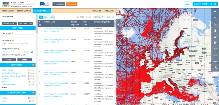
EMODnet Bathymetry - CDI Data and Discovery Access Service (SeaDataNet service)
Bathymetry Products Discovery service
The EMODnet Bathymety maintains a Catalogue service to document composite DTMs, DTM tiles and High Resolution DTMs, that have been contributed by a number of data providers. The Composite DTMs (CPRDs) are used as input for the EMODnet DTM together with the higher resolution survey data sets as described in the EMODnet Bathymetry - CDI Data and Discovery Access Service. The metadata of these CPRDs can be retrieved through interrogating the Source Reference map in the Central Map Viewing service. While the metadata and download links of the DTM tiles and the High Resolution DTMs can be found through the central Products Catalogue.
High-Resolution DTM Discovery and Access
EMODnet Bathymetry brings together already more than 200 DTMs in higher resolutions (higher than 1/16 arc minutes grid up to even 1/512 arc minutes grid) for selected areas, in particular for near coastal waters and coastal zones, and hotspots in open water with interesting seabed features. These are made available in the Central Portal Data Products Catalogue for browsing and downloading. Moreover, these HR-DTMs can be viewed in the High-Resolution map layer in the Map viewer.
Viewing and Download service
The various Bathymetry map layers are made available in the Central Portal Map viewer which allows users to view, browse and download digital bathymetry as DTM tiles and to obtain information about the underlying data sets used to compile the DTM. This map viewing service provides users with a range of functions for browsing and downloading the EMODnet DTM such as:
- Multiple map layers that can be switched on / off and each interrogated for their specific information;
- Zoom in - zoom out and panning;
- Retrieval of the DTM cell parameters such as minimum cell depth, maximum cell depth, average cell depth, standard deviation of the cell depth, number of depths used for interpolation of cell depth, number of subcells used for the computation of the average cell depth, source reference by CDI reference, composite DTM reference or GEBCO in case of missing data;
- Retrieval of depth profiles along a track;
- Addition of external WMS map layers as an overlay such as the CDI WMS layer;
- Activation of a source layer indicating for each cell its underlying prevailing data source;
- Downloading of DTM tiles in different formats: ESRI ASCII, XYZ, CSV, NetCDF, GeoTiff and SD for Fledermaus 3 D viewer software.
3D visualization of the latest EMODnet DTM
It is made possible without plug-ins. For this purpose a method and software were developed for generating a TIN model from the EMODnet DTM which is instrumental for supporting stable 3D viewing using Cesium. The approach for the 3D software is described in a document while the software source can be found at GitHub .
Data providers
In the field of bathymetry, a number of Data Centres in SeaDataNet manage bathymetric data sets, such as multibeam surveys from scientific cruises. There are other parties engaged in the provision of bathymetric data: Hydrographic Offices; Authorities; Research institutes; Industry.
Hydrographic offices
Hydrographic offices (HO) are responsible for surveying the navigation routes, fairways and harbour approach channels and producing from these the nautical charts on paper and as Electronic Nautical Charts (ENC), that are used for navigation. The HO's are members of the International Hydrographic Organisation (IHO), that has its data policy, which supports restrictions in the delivery of high resolution data sets, mostly for safety and security reasons. Moreover, nautical charts have a legal status. Every ship captain must use certified nautical charts and the production and publication of these is an activity which must follow stringent international procedures. The latter results in a condition that HO's are careful in delivering and distributing bathymetric survey data sets.
Authorities
Authorities are responsible for management and maintenance of harbours, coastal defences, shipping channels and waterways. These authorities operate or contract regular bathymetric monitoring surveys to assure that an agreed nautical depth is maintained or to secure the state of the coastal defences.
Research Institutes
Research institutes, that collect multibeam surveys as part of their scientific cruises.
Industry
Industry, especially the energy industry, that contracts multibeam surveys for pipeline and cable routes (in case of windfarms) and the telecommunication industry for phone and internet cable routes.
These organisations perform and manage bathymetric surveys, partly overlapping and mostly complementing their geographical coverages. Data are collected at different frequencies and even date back to previous centuries. In addition, Satellite Derived Bathymetry data products are experiencing increased uptake because it is becoming an operational and robust technology. Optical sensor images provide a rapid and effective way to derive bathymetry in coastal zones up to 15 metres depth depending on the transparency of the water column.
IHO DCDB Viewer service
EMODnet Bathymetry web services (OGC WMS and WFS) of available survey data sets by European data providers are integrated in the IHO DCDB Data Viewer, which is provided by the IHO Data Centre for Digital Bathymetry (DCDB). The IHO DCDB was established in 1990 to steward the worldwide collection of bathymetric data. The Centre archives and shares, freely and without restrictions, depth data contributed by mariners. The IHO DCDB is hosted by the U.S. National Oceanic and Atmospheric Administration (NOAA) on behalf of the IHO Member States. The IHO DCDB Data Viewer shows the global coverage of the DCDB's bathymetric data holdings as well as the spatial extent of data archived at other repositories via web services, such as the EMODnet Bathymetry collection of single and multibeam survey data sets.
Visit the IHO DCDB Viewer Service
Clicking on a survey line pops up references, by which more details about the surveys and their availability can be found.
Background
EMODnet Bathymetry was launched in 2009 with a steadily increasing number of services, metadata and data products.
-
End 2024 - Begin 2025Products and layers update
- Baseline and coastline data (2024)
- Best-estimate coastlines (version 2024) from satellite data
- DTM tiles for European seas and Caribbean (version 2024) at LAT and MSL
- Multi-resolution layer expanded with more HR-DTMs
- Quality Index layer 2024
-
End 2022 - Begin 2023Products and layers update
- Baseline and coastline data
- Best-estimate coastlines (version 2022) from satellite data
- DTM tiles for European seas and Caribbean (version 2022) at LAT and MSL
- Multi-resolution layer expanded with more HR-DTMs
- Quality Index layer
-
End 2020 - Begin 2021Products and layers update
- Baseline and coastline data
- Best-estimate coastlines (version 2020) from satellite data
- DTM tiles (version 2020) at LAT and MSL
- Multi-resolution layer expanded to HR-DTM
- Quality Index layer
-
End December 2020New DTM release
- DTM with a 1/16*1/16 arc-minutes (115 * 115 minutes) resolution
- Satellite Derived Bathymetry (SDB) datasets for coastal zones (Cyprus, Croatia & part of Denmark)
-
Middle 2020EMODnet Bathymetry World Base Layer (EBWBL) layer & OGC WMTS service
-
Early 2019New products and layers released
- Baseline and coastline data (21 national autorithies)
- Best-estimate coastlines were from satellite data combined with GTSM
- GTSM DTM tiles (version 2018) at LAT and MSL reference levels
- Multi-resolution layer of HR-DTMs for selected regions
- Quality Index map layer
-
Mid-September 2018New DTM release
- DTM with increased resolution (from 1/8 to 1/16 arc-minutes)
- DTM geographic coverage expanded to include European Arctic region and Barents Sea
- Satellite Derived Bathymetry (SDB) datasets for coastal zones (Spain & Greece)
- Upgrade of Viewing and Download service: 3D visualisation (no plugins needed)
-
Early October 2016New DTM release (16 tiles)
-
Early September 2015New DTM release
HR-DTM for coastal waters (German North Sea, French Mediterranean & Irish Dunmanus bay
-
Early February 2015Expanded digital bathymetry
- Geographic coverage: all European sea regions
- Increased resolution (from 1/4 to 1/8 arc-minutes)
- Upgrade of Viewing and Download service
-
July 2013Digital bathymetry updated
Iberian - Bay of Biscay region, Eastern Mediterranean and Adriatic Sea regions
-
July 2012Digital bathymetry updated
- Geographic coverage extension to include Madeira - Azores
- Browsing and downloading service extended with a Personal library
- Addition of Sextant Catalogue service to describe the composite DTMs metadata
-
June 2011Digital bathymetry updated
- Geographic coverage extension to include Atlantic region, Adriatic Sea, Ionian Sea & Eastern Mediterranean
- Major update of the 'Browsing and downloading service' to made more user-friendly and efficient
-
May 2010Digital bathymetry
Geographic coverage: North Sea, Celtic Seas, Channel, Western and Central Mediterranean Seas.
Partnership
EMODnet Bathymetry is operated and further developed by a European partnership. This comprises a network of marine research institutes, national hydrographic services, hydrographic survey companies, and members of the SeaDataNet consortium who support the data management challenges.
The partners combine expertises and experiences of collecting, processing, and managing of bathymetric data together with expertises in distributed data infrastructure development and operation and providing OGC services (WMS, WMTS, WFS, and WCS) for viewing and distribution.
You can find the full and update list of the consortium on the following section of the website “Partners”.
SeaDataNet
SeaDataNet is a leading infrastructure in Europe for marine & ocean data management, initiated and managed by the National Oceanographic Data Centres (NODC's). It is actively operating and further developing a Pan-European infrastructure for managing, indexing and providing access to ocean and marine data sets and data products, acquired via research cruises and other in-situ observational activities. The basis of SeaDataNet is interconnecting Data Centres into a distributed network of data resources with common standards for metadata, vocabularies, data transport formats, quality control methods and flags, and access
SeaDataNet is aiming for an extensive coverage of available data sets for the various marine environmental disciplines, such as physical oceanography, marine chemistry, biology, biodiversity, geology, geophysics and bathymetry. This is implemented by seeking active cooperation at a national scale with institutes and at a European scale with communities, that are engaged in data management for these disciplines, and by seeking opportunities for including their data centres and data collections in the SeaDataNet metadata and data provision.
Communication
In this section you will find thematic-specific communication material, and a direct link to the video gallery.