Our latest release of the well-established EMODnet Bathymetry Digital Terrain Model (DTM) marks another step forward in improving our understanding of the marine environment—an effort to which the European Commission and the EMODnet Bathymetry consortium remain fully committed.
This release has benefited from significant enhancements thanks to our extensive community of collaborators, contributors, and experts. The updated bathymetry product offers:
- Enhanced resolution of 1/16 × 1/16 arc minutes (approximately 115 × 115 meters), covering all European seas, including the Mediterranean Sea, the Black Sea, the Greater North Sea, the Baltic Sea, the North East Atlantic Ocean, the Arctic Ocean, the Barents Sea, and the Caribbean region.
- Bathymetric information derived from diverse observation sources, including acoustic data (multibeam, single beam, leadline), airborne bathymetric Lidar, and satellite multispectral imaging (such as Sentinel-2).
- A reference layer and a quality index layer directly linked to 22,063 dataset entries, comprising 21,890 bathymetric survey datasets and 173 composite DTMs. This marks an overall increase of 126 additional referenced datasets compared to the 2022 release, with multiple older surveys replaced by more recent data.
- Catalogued 43,092 unique descriptions of data surveys and 299 composite DTM or Satellite-Derived Bathymetry products, originating from European data holders, covering European coasts and extending to global ocean regions in cooperation with the European SeaDataNet infrastructure.
- Snapshots of higher-resolution DTM products.
- Updated coastline data for improved land-water separation.
- Integration of the latest global and regional bathymetric datasets, including GEBCO 2024, IBCAO 5, and GMRT.
- Enhanced OGC and REST web services.
- Support for both EPSG 4326 and Web Mercator (EPSG 3857) in OGC web services, viewable in the EMODnet Central Portal. The render resolution of web services has doubled compared to the 2022 release in both 2D and 3D viewers, delivering unprecedented detail in large-scale bathymetric web services. Combined with advanced hill shading algorithms, this update provides a vastly improved visualization experience.
- An associated DOI for reference and citation.
“This new version of the EMODnet Bathymetry product strengthens our understanding of European waters and parts of the global ocean, both in terms of coverage and quality. It represents a dedicated contribution from European bathymetric data holders and specialists towards the Nippon Foundation-GEBCO Seabed 2030 target,” Thierry Schmitt, Shom (Service Hydrographique et Océanographique de la Marine), Coordinator of EMODnet Bathymetry.
Enhanced Visualizations of the New Grid
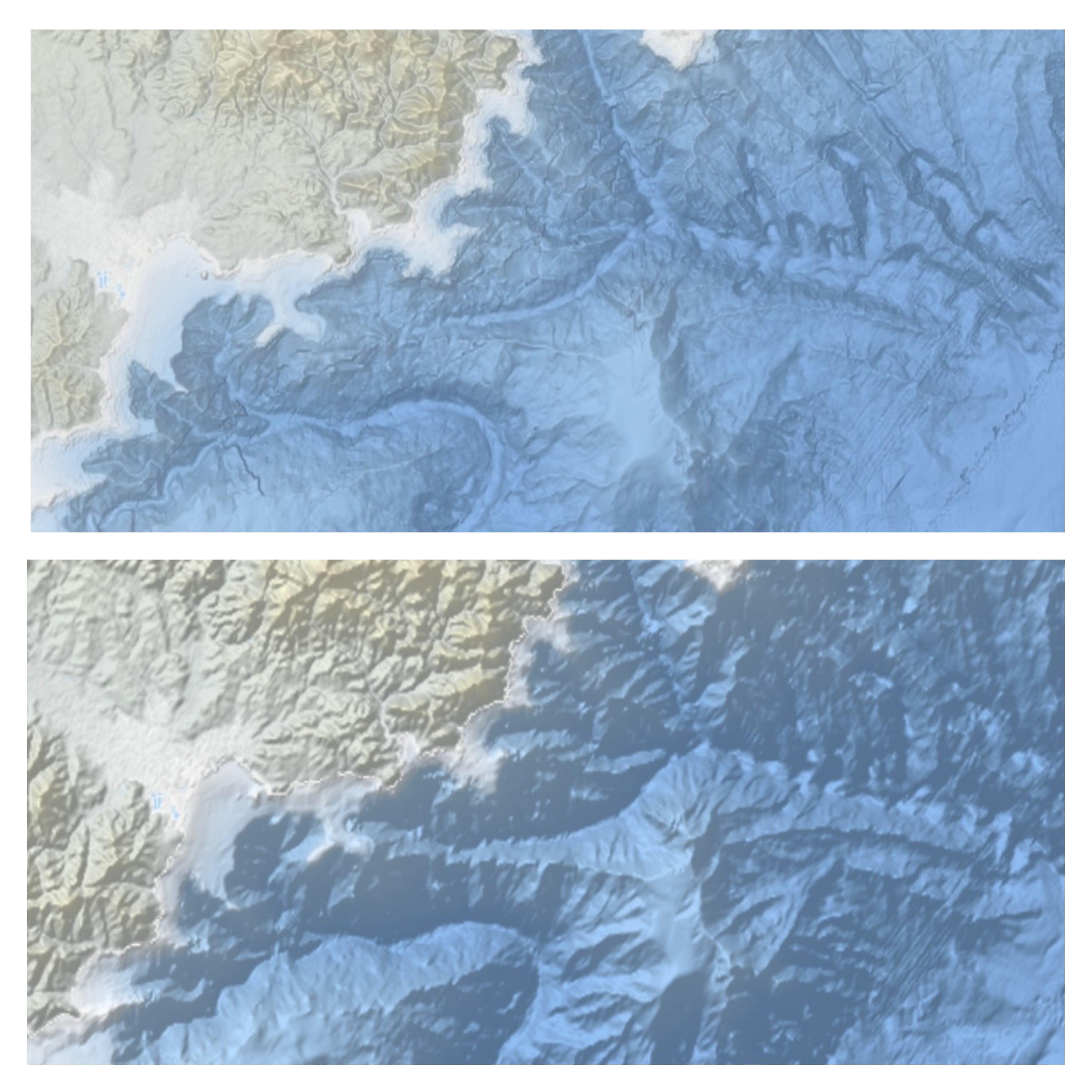
Figure 1: Rendering of the 2022 release vs the 2024 release. ©EMODnet Bathymetry
For more details, visit the EMODnet Bathymetry portal.
About EMODnet Digital Bathymetry
First launched in 2010, the EMODnet Digital Bathymetry (DTM) has become a widely used reference for government, science, and industry, making it the most popular EMODnet product. With thousands of monthly visitors and over 3,200 downloads per month, it provides the most detailed publicly available gridded bathymetry model for all European marine waters.
The EMODnet DTM allows users to:
- Activate and visualize bathymetry layers, contours, and underwater features.
- Zoom in/out, switch layers, browse data, and access metadata about the underlying data sources.
As part of its ambition to continuously improve quality and accuracy, particularly for European offshore waters and coastal zones, EMODnet welcomes high-resolution bathymetric data providers to contribute towards an even more refined DTM product. To learn more, visit EMODnet Data Ingestion.
About the UN Decade of Ocean Science for Sustainable Development
Proclaimed in 2017 by the United Nations General Assembly, the UN Decade of Ocean Science for Sustainable Development (2021-2030)—also known as the Ocean Decade—aims to advance ocean science and knowledge generation to reverse ocean decline and support sustainable development.
The Ocean Decade’s vision is: "The science we need for the ocean we want."
This initiative provides a global platform for scientists and stakeholders across sectors to:
- Develop scientific knowledge and partnerships.
- Accelerate ocean science advancements.
- Deliver science-based solutions for a sustainable ocean future.
The United Nations General Assembly has mandated UNESCO’s Intergovernmental Oceanographic Commission (IOC) to coordinate the Ocean Decade’s implementation.
For more details, visit the Ocean Decade website.
About The Nippon Foundation-GEBCO Seabed 2030 Project
Seabed 2030 is a collaborative initiative between The Nippon Foundation of Japan and the General Bathymetric Chart of the Oceans (GEBCO).
Launched at the United Nations Ocean Conference in June 2017, Seabed 2030 coordinates and oversees the sourcing and compilation of bathymetric data from its five regional centers, integrating them into the freely available GEBCO Grid.
To learn more about Seabed 2030, visit: Seabed 2030’s official website.