Download the full press release in PDF
The EMODnet Geology team recently released a series of products related to topics including Seafloor geology, Marine minerals, Seabed substrates, Geological Events and Probabilities, and Submerged landscape features.
Seafloor geology
Within EMODnet Geology, the German Federal Institute for Geosciences and Natural Resources (BGR) compiles and harmonises the European marine geology map data with regard to geomorphology and pre-Quaternary and Quaternary geology. The three data layers show the underlying geology from the Ancient Past (more than 2500 Million years ago) to Quaternary deposits and modern geomorphological features, and therefore map Earth’s evolution in the European marine part. ”Geology does not know political boundaries, neither at sea nor on land”, says Kristine Asch from BGR, ”EMODnet geology products help users from science, governments, industry, fisheries and tourism to find and visualise detailed marine geology data from across European Seas”.
The layers provide information about structures on the seafloor, important for geoscience research and investigations of future exploration of mineral and energy resources but also of biological resources. They are also a source of knowledge to show features of the seafloor geomorphology valuable for habitats of numerous species (fisheries, tourism). In addition, the layers provide information on the sea floor conditions to plan building infrastructures such as wind parks, a pipeline or a protection area for endangered species.
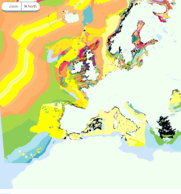
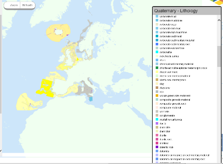
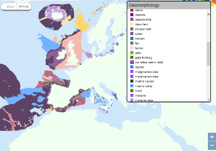
Upper: Pre-Quaternary geology (age) including data of IGMZ 5000 Overview Map of Europe and faults; Middle: Quaternary geology (lithology); Lower: Geomorphology. ©EMODnet
Marine minerals
The EMODnet Geology team responsible for the work package on Minerals, led by Geological Survey Ireland (GSI) with project partners from Russia to Iceland, Turkey to Portugal and all maritime countries, has accomplished broad ranging systematic mapping of recorded marine minerals known to accumulate in seas surrounding Europe. A first step consisted of creating guidance on marine mineral data layers and associated attributes which would allow partners to report important information on twelve mineral types. National data on marine minerals were then formatted and provided by project partners, and later merged into mineral type layers.
Information on the types of minerals has relevance to engineering disciplines including extractive industries, beach nourishment and reclamation projects. Those who draw policies on the designation of areas for protection as well as licencing for mineral extraction can use these data in planning. Environmental and climate scientists who may be interested in the sea level rise and chemical interactions within our oceans can glean useful information from some of the mineral types listed.
A project investigating the metallogeny and geological potential for strategic and critical raw materials on the European seabed called GeoERA MINDeSEA is already using EMODnet Geology Minerals data for analysis. “EMODnet data on ferromanganese crust and nodules, rich in cobalt, tellurium, rare earth elements and other strategic and critical metals, have been used by MINDeSEA as starting points to produce the first compilation of energy-critical elements in pan-European seas”, said Javier González, coordinator of MINDeSEA, from the Geological Survey of Spain. “EMODnet-Geology data will be very useful to plan future research and exploration targets for minerals with exploitation potential and to define areas for environmental protection”.
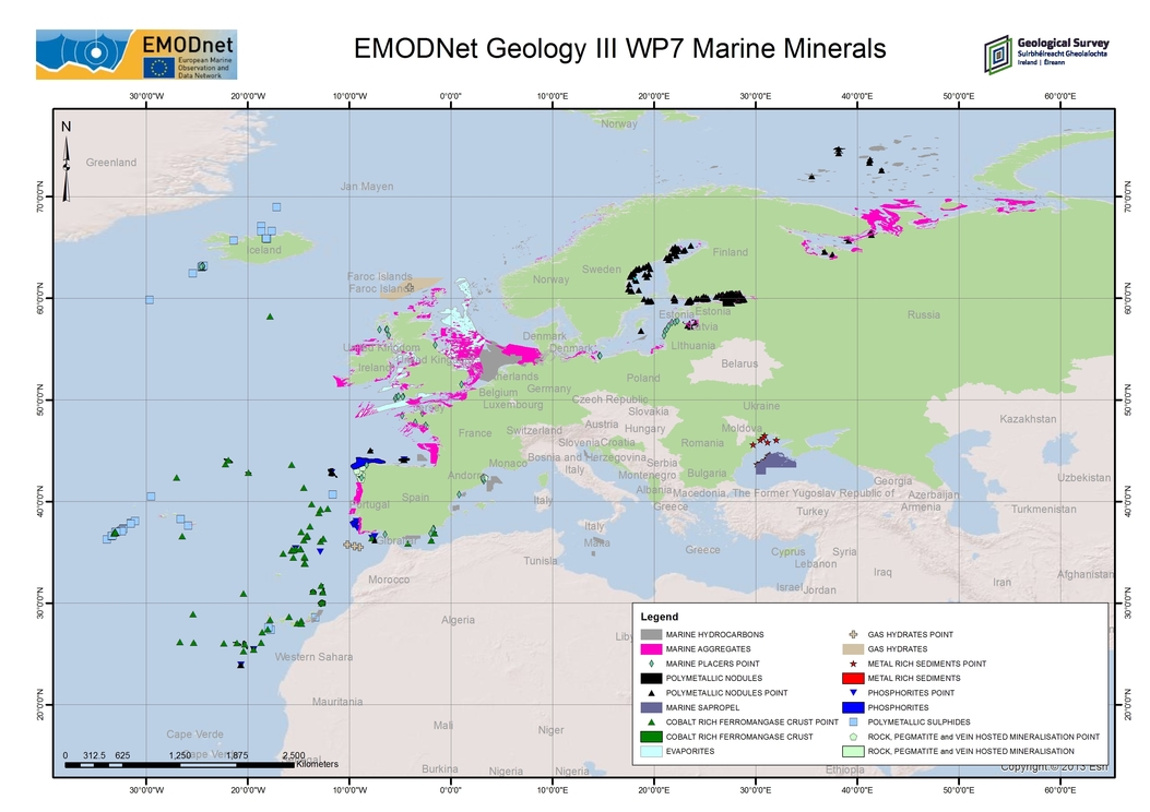
©EMODnet
Submerged landscapes
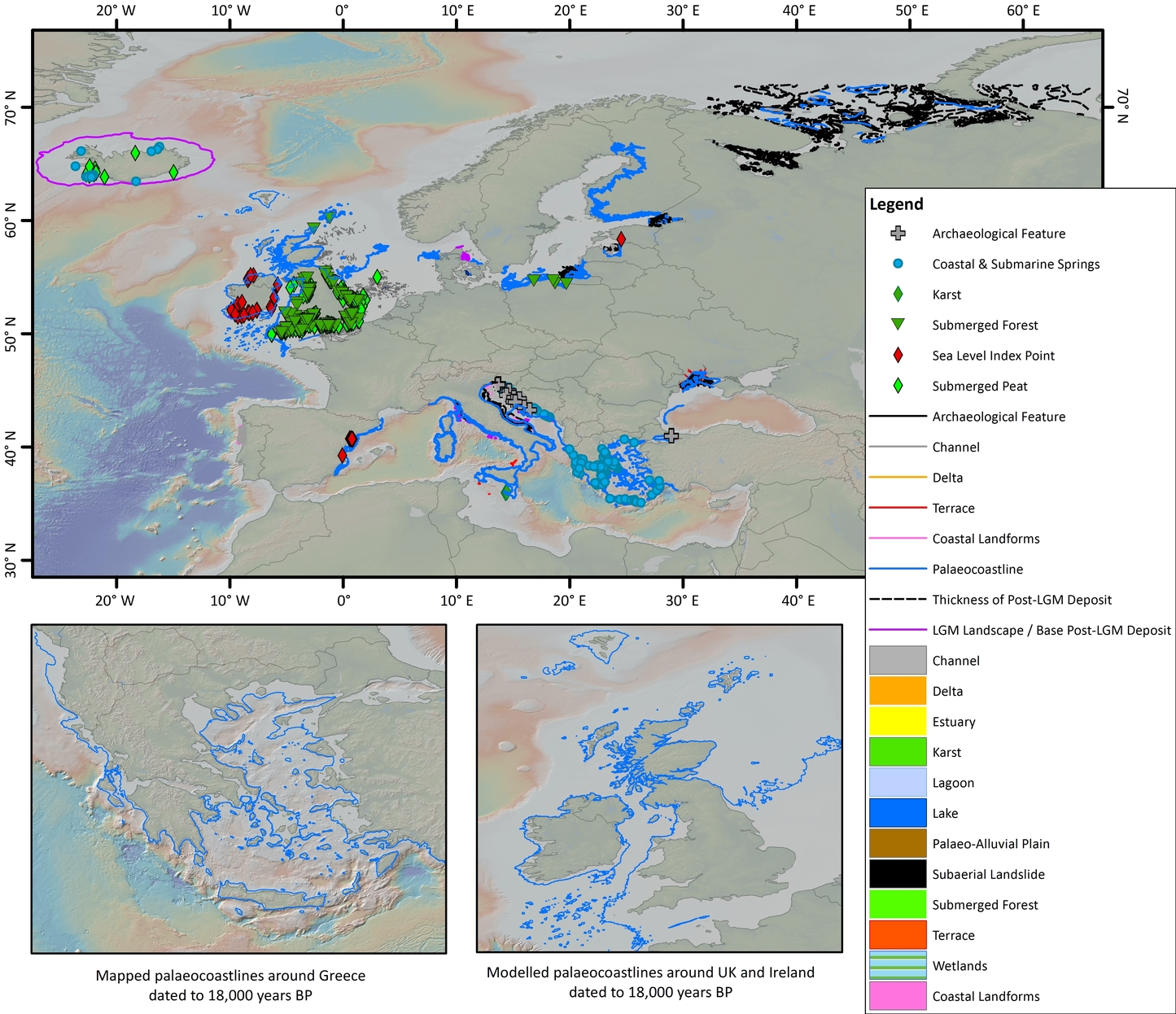
Landscape responses to changes in sea level over repeated glacial cycles and the preservation of these features on continental shelves around Europe, are an invaluable resource for improving our understanding of human history and environmental change over geological time. The EMODnet Geology team responsible for the work on Submerged Landscapes, led by the British Geological Survey (BGS), delivered a compilation of submerged landscape features and palaeo-environmental indicators, including estimated age where known. The fully attributed GIS-layer will be used to underpin palaeogeographic reconstructions across various time frames. “This is the first time information on the character and evolution of submerged landscape features have been collated and harmonised across European Seas”, said David Tappin, coordinator of the team delivering the compilation.
The aim of this activity was to compile and harmonise available information on submerged landscape features by integrating existing records of palaeo-environmental indicators with interpretations of geomorphology, stratigraphy and type of sediment. “Submerged landscape features have been mapped previously on many European shelf areas, but never before has a harmonised GIS been attempted”, David Tappin added.
©EMODnet
Geological events and probabilities
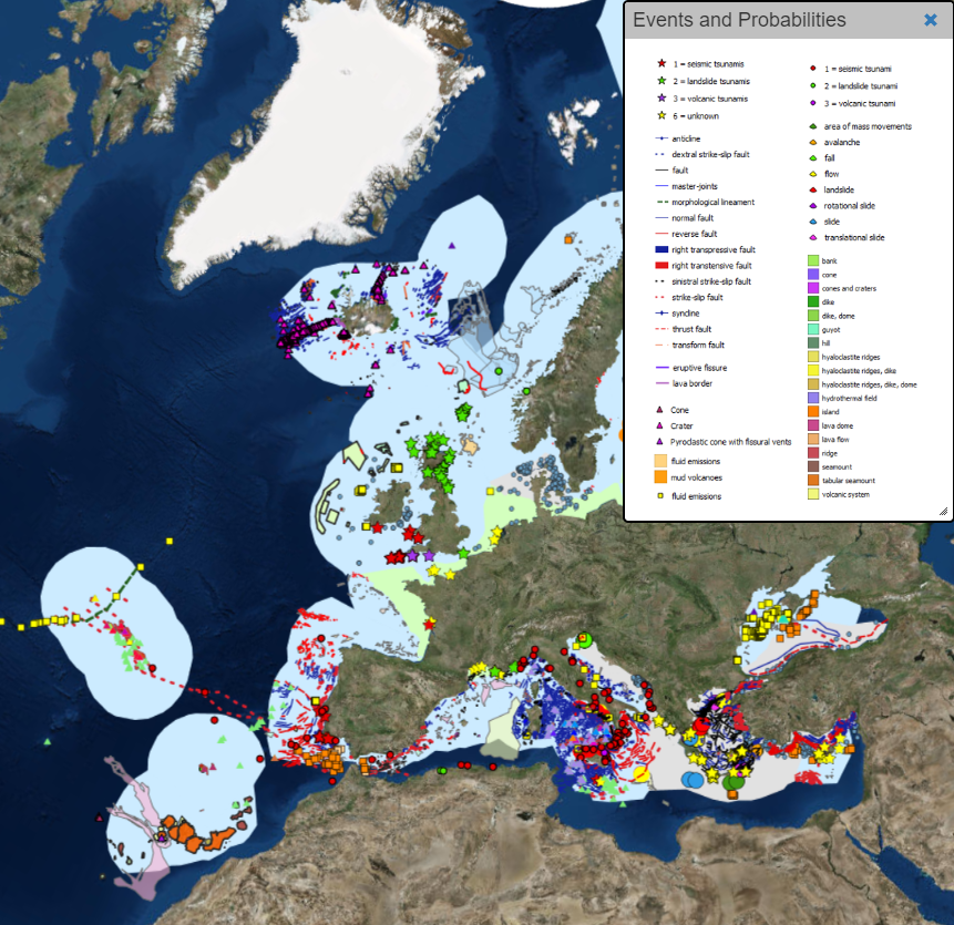
The Geological Survey of Italy (ISPRA) has led the production and release of new datasets on Geological Events and Probabilities. Twelve new GIS layers at a resolution of 1:100 000 were added, representing a systematic collection of harmonised data concerning geological events, providing information on the type of events that have taken place in the past and might potentially occur again, including dimensions, state of activity, morphological type and lithology. The layers concern earthquakes, submarine landslides, volcanoes, tsunamis, fluid emissions and Quaternary tectonics. These products complement and update the 1:250 000 scale GIS layers already displayed on the Geology Portal.
Particular attention has been devoted to the definition of the attribute tables in order to achieve the best degree of harmonisation and standardisation complying with the European INSPIRE Directive. Information contained in the attribute tables of the different shape files could be applied in the management of coastal areas and to support planning of further surveys. By combining the diverse information contained in the different layers, it might be possible to elaborate additional thematic maps which could support further research. Moreover, they potentially represent a useful tool to increase awareness of the hazards which might affect coastal areas.
©EMODnet
Seabed substrate
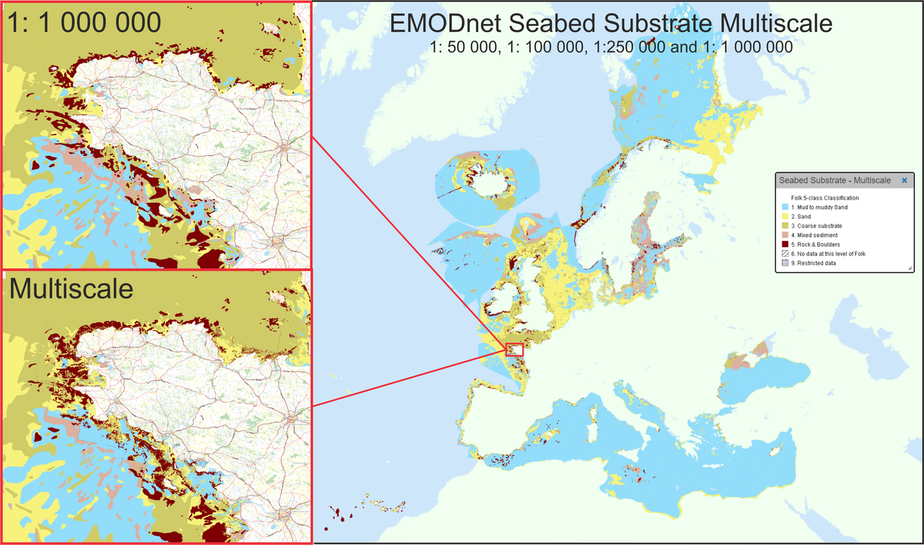
Another product released, led by The Geological Survey of Finland (GTK), consists of harmonised maps of the seabed substrate. Diverse national seabed substrate data classifications are brought together, harmonised and collated using the Folk classification system of 5, 7 and 16 classes. The multiscale maps illustrate seabed properties at different scales – 1:50 000, 1:100 000, 1:250 000 (250 k) and 1:1 000 000 (1 M) – covering all European maritime areas in one product. The broad scale data (250 k and 1 M) describes the seabed substrate at a general level, suitable for the decision-making, research and large-scale spatial planning. More detailed scale data are needed, for instance for habitat mapping purposes and planning local constructions like wind farms.
©EMODnet