“This new version of the EMODnet Bathymetry Digital Terrain Model is a further upgrade to the existing data product. The 2022 version integrates bathymetric data from even more data providers and diverse sources to deliver a number of key upgrades including higher resolution and updated coastlines of European seas, coupled with extended geographical coverage, including the Caribbean arc. All these upgrades make the 2022 DTM even more fit-for-use by EMODnet’s ever-expanding and diversifying user community, further strengthening EMODnet’s contribution to major global initiatives such as the United Nations Decade of Ocean Science for sustainable development and the Nippon Foundation-GEBCO Seabed 2030 project” states Thierry Schmitt from SHOM (Service hydrographique et océanographique de la marine), the French Naval Hydrographic and Oceanographic Service, Coordinator of EMODnet Bathymetry.
Beyond constant improvements brought to the well-known exiting DTM in the European waters at 100 meters resolution, the major breakthrough of the new EMODnet Bathymetry release is the extension of the coverage of interest to the Caribbean Sea as illustrated on the following view.
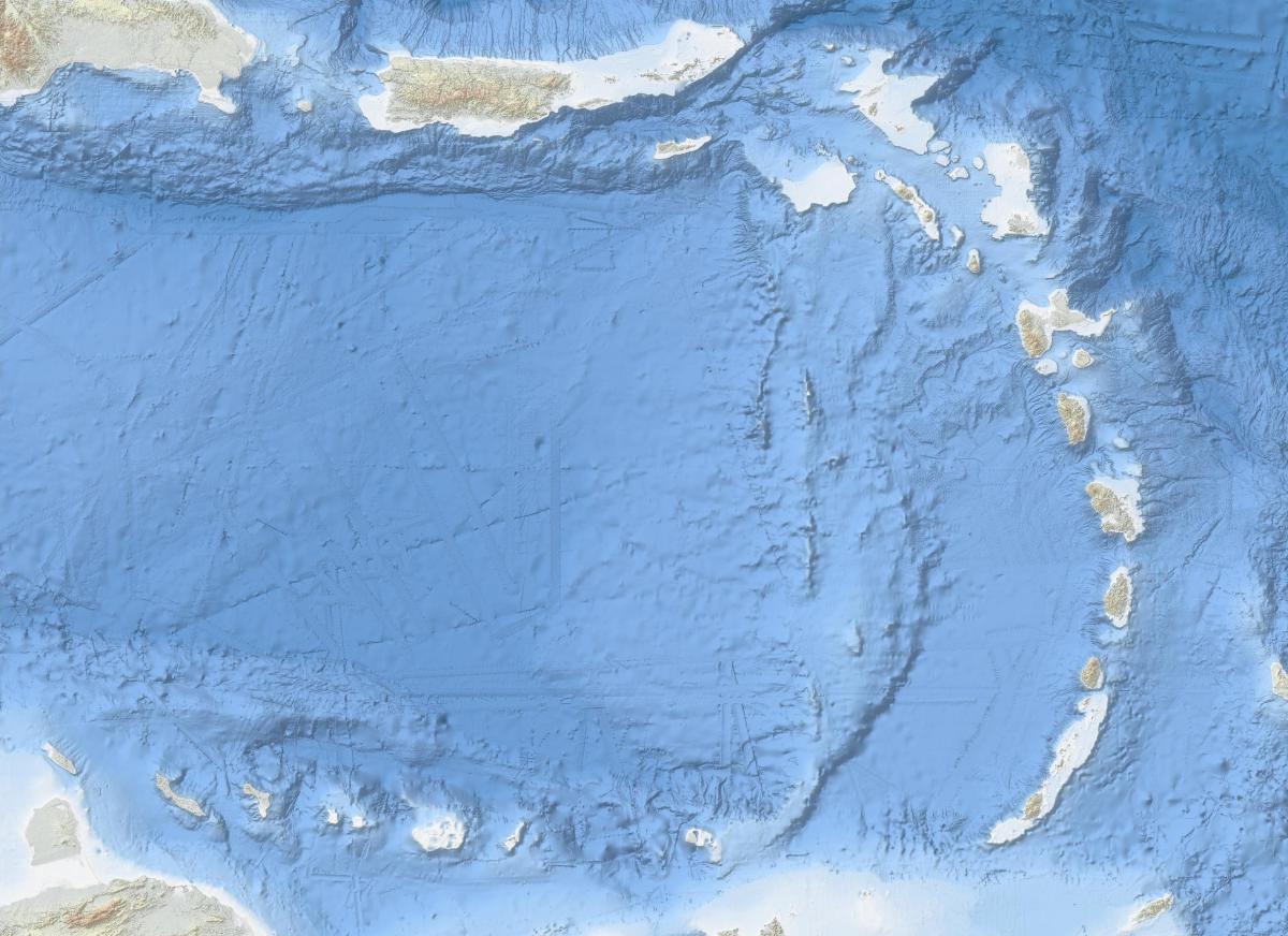
Carribean 2022
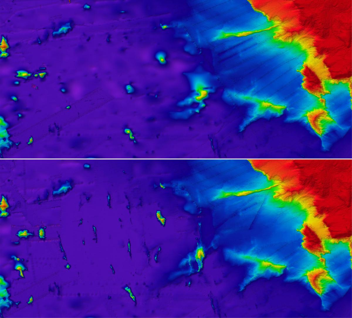
Atlantic Ocean, Porcupine abyssal plane
The new release Digital Terrain Model can be discovered, viewed and downloaded on https://emodnet.ec.europa.eu/en/bathymetry
For more details on the European Marine Observation and Data Network Bathymetry portal, visit https://emodnet.ec.europa.eu/en/bathymetry
Further information
European Marine Observation and Data Network (EMODnet)
For over a decade, more than 120 organisations involved in the European Marine Observation and Data Network (EMODnet) have been working together to aggregate observations and data from various sources, process them according to international standards and make that information freely available as interoperable data layers and data products for re-user by others. This "collect once and use many times" philosophy benefits all marine data users, including policy makers, scientists, private industry and the public. It has been estimated that such an integrated marine data service creates great savings in cost and effort, improves the accuracy of marine research as well as opens up new opportunities for innovation and growth.
On 25 January 2023 EMODnet reached a new stage as it launched its fully centralised marine data service, integrating all of its thematic services into one single portal. This thematic unification is a major upgrade, which simplifies access and enhances the EMODnet user experience. Central to the upgrade and major improvement is the release of the common map viewer, which offers the user easy and seamless access to discover, visualise and download marine data across seven thematics spanning marine environment and human activities and hundreds of data and data products from one place, powered by a searchable unified catalogue. By providing a single-entry point to all EMODnet data, data products and services, the new portal offers services more suited to today’s data driven world and supports next generation ocean data and information management, as well as new technologies and approaches such as Artificial Intelligence.
EMODnet Digital Bathymetry
First launched in 2010, the EMODnet Digital Bathymetry (DTM) has now become a reference for government, science and industry, being by far the most popular EMODnet product. Regularly visited by over 10.000 persons per month with over 3.000 downloads per month, it provides the most detailed publicly available gridded bathymetry model for all European marine waters. The EMODnet DTM allows users to activate and view bathymetry layers as well as contours and underwater features for the selected areas. Among other functionalities, it is possible to zoom in/out, to switch on/off several layers, as well as to browse data and look up metadata about the underlying data source.
Updated on a regular basis, key features of the 2022 release are:
- 1/16 * 1/16 arc minutes (circa 115 * 115 meters) including all European seas from the Mediterranean Sea, the Black Sea, the north-east Atlantic Ocean, up to the Arctic Ocean and Barents Sea and the Caribbean arc
- Bathymetric information brought in by complementary methods (mainly in situ observational data based on acoustics but also from airborne bathymetric Lidar and from satellite multispectral imaging (such as Copernicus Sentinel 2)
- A reference layer and a quality index layer pointing directly to one of the 17376 dataset entry (from which 17329 bathymetric survey data sets and 137 composite DTMs) used in the 2022 version
- Catalogued Over 41315 unique description of data surveys, 274 composite DTM or Satellite Derived Bathymetry product originating from European data holders, along European coasts and around the world in co-operation with the European SeaDataNet infrastructure
- Snapshot of higher resolution DTM products
- Updated coastline for land water separation
- Integration of the latest GEBCO 2022, IBCAO 4.2 and GMRT grids
- Associated OGC and REST web services Map
- Both EPSG 4326 and Web Mercator (EPSG 3857) are now selectable in the OGC webservices
- An associated Digital Object Identifier (DOI)
EMODnet Bathymetry services are continuously evolving and acknowledges the key role and contribution of data collectors and providers supplying bathymetric data that are harmonised, standardized and integrated into high resolution data layers underpinning the DTM product. With the ambition to refine further the quality and the accuracy of the DTM, considering both European offshore waters and coastal zones, EMODnet invites potential high-resolution bathymetric data providers to help generate an even better DTM product. Visit our EMODnet Data Ingestion portal to learn more!
About the UN Decade of Ocean Science for Sustainable Development
Proclaimed in 2017 by the United Nations General Assembly, the UN Decade of Ocean Science for Sustainable Development (2021-2030) (‘the Ocean Decade’) seeks to stimulate ocean science and knowledge generation to reverse the decline of the state of the ocean system and catalyse new opportunities for sustainable development of this massive marine ecosystem. The vision of the Ocean Decade is ‘the science we need for the ocean we want’. The Ocean Decade provides a convening framework for scientists and stakeholders from diverse sectors to develop the scientific knowledge and the partnerships needed to accelerate and harness advances in ocean science to achieve a better understanding of the ocean system and deliver science-based solutions to achieve the 2030 Agenda. The UN General Assembly mandated UNESCO's Intergovernmental Oceanographic Commission (IOC) to coordinate the preparations and implementation of the Decade. For more information, visit https://www.oceandecade.org/
About The Nippon Foundation-GEBCO Seabed 2030 Project
Seabed 2030 is a collaborative project between The Nippon Foundation of Japan and the General Bathymetric Chart of the Oceans (GEBCO). Launched at the United Nations (UN) Ocean Conference in June 2017, Seabed 2030 coordinates and oversees the sourcing and compilation of bathymetric data from its five centres into the freely available GEBCO Grid.
Key Contacts
For more information on the technical aspects of the EMODnet Services:
Thierry Schmitt
Deputy head of the Bathymetry Department of the French Hydrographic Service (SHOM) EMODnet Bathymetry Coordinator
Email: thierry.schmitt@shom.fr
Phone: +33 (0) 2 56 31 21 95
For more information on the EMODnet partnership and available communication materials:
Angelika Karampourouni
Communication & Partnership Relations Officer, EMODnet Secretariat
Email : angelika.karampourouni@emodnet.eu
Mobile : +32 (0) 493705752
The new EMODnet Portal and all data services are is available at
Please visit this exciting new service and
explore, visualise and download EMODnet data and products