Habitat models can be called a variety of names; Species Distribution Models, Habitat Suitability Models, Predictive Habitat Models to list but a few. Despite the numerous titles under which they can be categorised, there can’t be any disagreement with the importance that they have in building our understanding of the spatial distribution of marine habitats of conservation interest.
Models are particularly effective in predicting habitats in offshore areas that would otherwise be prohibitively expensive to map using conventional methods e.g. multibeam echosounder imagery and samples. The use of point observations and existing full-coverage environmental data products to predict the spatial distribution of a habitat is not only more cost-effective but also factors in other environmental conditions that might affect the presence or absence of a key species or habitat. In some instances, substrate maps or broad habitat type maps on their own, are insufficient to capture stakeholders' mapping requirements. A 2021 ICES workshop on the “Use of Predictive Habitat Models in ICES Advice” provided benchmark standards for the use of models in ICES advice related to the distribution of Vulnerable Marine Ecosystems (VMEs).
One advantage models have over conventional habitat maps is that they can be used to predict likely habitat distribution scenarios in the future. This is very important in planning for the mitigation of the detrimental effects of Climate Change and Ocean Acidification on marine habitats.
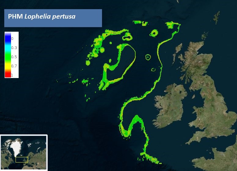
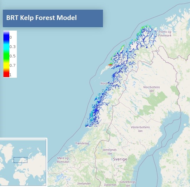
The EMODnet Seabed Habitats map viewer contains over 80 modelled maps of specific habitat type. Models showing the predicted presence/absence of OSPAR habitats such as Lophelia pertusa and the newly listed Kelp Forests, are available to view, download or add as a web mapping service (WMS). Models for other Regional Sea Convention areas include spatial distributions of coralligenous outcrops across the Mediterranean Sea and over 20 species distribution models in the Baltic Sea. Norway has the largest number of models submitted by any country to EMODnet Seabed Habitats with over 30 models showing the predicted distribution of important species and habitats on the map viewer.
Media