Objectives
Challenge 5 objectives had been divided in two main tasks:
- construct fishery data sets of fish landings, discards and by-catch for assessing the quality, extracting the synergies and identifying the gaps of the fishery data collection systems in the Mediterranean Sea.
- deliver maps showing the extent of the trawling fishing grounds for identifying the areas which are most disturbed by bottom trawling, and the changes in level of disturbance over the past ten years, as well as identifying the gaps in fishing vessels’ tracking systems for the Mediterranean Sea.
Methodology
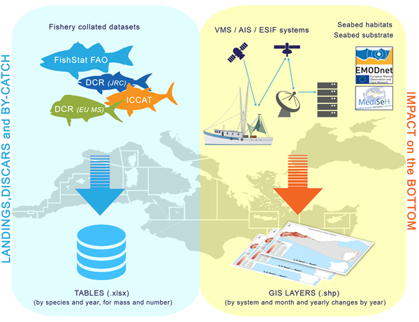
For the first task the landing, discard and by-catch data are compiled using the information gathered in the framework of DCR/DCF, FAO-FishStat and ICCAT databases.
For the second task the impact of trawling on the sea bed is estimated using data recorded by Vessel Monitoring System (VMS), Automatic Identification System (AIS) and GPS logger data collected by the ESIF system (developed within EU project “Energy Saving In Fisheries” financed in the framework of the open call for tenders Fish/2006/17-LOT3). Biota-biology and seabed layers (seabed habitats and substrate) are considered to evaluate the impact on the bottom.
Data Sources
The production of the targeted products were based on the following input characteristics:
- Fish and shellfish catch statistics, mass of landings of fish by species, country and year (excluding shellfish) from ICCAT Statistical Bulletin, DCR/DCF (European Commission) and FAO FishStat
- Fish and shellfish catch statistics, mass of discards of fish by species, country, year (excluding shellfish), DCR/DCF (European Commission)
- Horizontal platform movement, maps by France, Italy, Cyprus, Greece, Slovenia and Malta – VMS data from fishing vessels
- Horizontal platform movement, AIS raw data from fishing vessels
- Horizontal platform movement, GPS logger raw data from fishing vessels (ESIF system, CNR-ISMAR)
- Map of seabed substrate (EMODnet- Geology portal)
- Map of seabed habitats (MediSeh project)
Targeted Products
Final Challenge Report: MedSea Checkpoint Challenge 5 (Fishery Management): Description of Targeted Products, the methodology and the expert evaluation of fitness for purpose
How to Cite: “Fabi, G., Scarcella, G., Tassetti, A. N., Ferra’, C., Pellini, G., Sala, A., … Simoncelli, S. (2017). EMODnet MedSea CheckPoint Challenge 5 (Fisheries Management) Report. European Marine Observation and Data Network. https://doi.org/10.25423/cmcc/medsea_checkpoint_challenge5“
Team Involved
Gianna Fabi (CNR – ISMAR), Giuseppe Scarcella (CNR – ISMAR), Nora Tassetti (CNR – ISMAR), Carmen Ferrà Vega (CNR-ISMAR), Giulio Pellini (CNR – ISMAR), Antonello Sala (CNR – ISMAR), Emilio Notti (CNR – ISMAR), Fabrizio Moro (CNR – ISMAR), Jacopo Pulcinella (CNR – ISMAR)