This week, the European Atlas of the Seas will be at the Science is Wonderful! science fair in Brussels. A good opportunity to discuss marine open data which can be visualised thanks to maps in the Atlas.
Have you heard of “open data”? Open data is data that anyone can access, use and share. Open data can help bring diverse benefits to governments, businesses and civil society [1]. The European Union (EU) aims to strengthen European cooperation through open data initiatives, such as the European Open Data Days 2025. Taking advantage of open data’s potential, data providers, enthusiasts, and users will come together for the EU Open Data Days on 19-20 March 2025 [2]. The participants will share success stories, discuss challenges, explore data visualisation, promote skill-building and innovation, while also supporting EU initiatives like the European Open Data Directives, which aims to enhance the data economy and promote digital innovation.
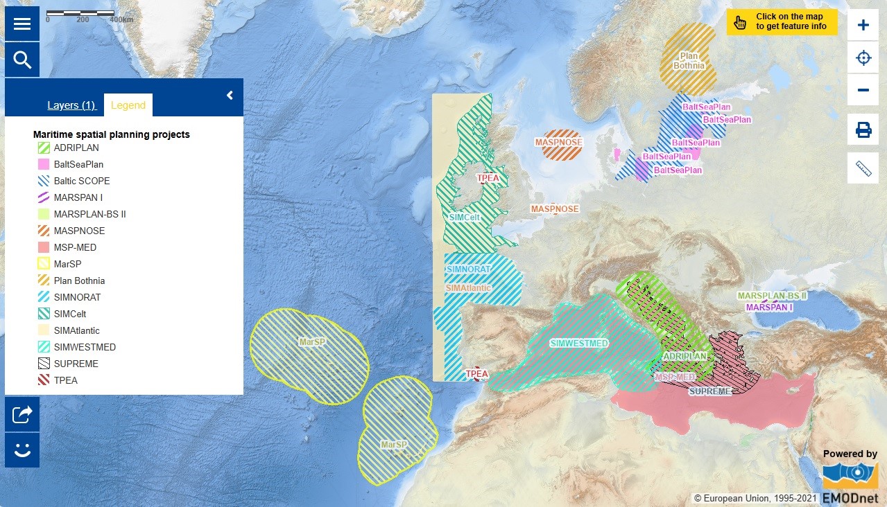
Open data is of interest, for example, for Marine Spatial Planning (MSP). Ocean resources are limited, and to prevent overexploitation of these resources, it is vital to plan the timing and execution of human activities that occur. Our ocean and seas support many human activities, such as transport, fishing, energy, minerals, tourism, and recreation, from which open data can be collected. Marine Spatial Planning utilises this data to manage our ocean and seas, providing a better understanding of the impact, and ensuring human activities are conducted efficiently, safely and sustainably [4]. There are currently 15 MSP projects spanning Europe, as seen in the Atlas MSP map layer above, that turn quality open marine data into spatial information to make accurate and sustainable decisions regarding human activities. Through the European Commission’s creation of a Maritime Spatial Planning Data Framework, MSP projects are provided with a standard process and structure which helps organise the partial information and manage these data sources more efficiently. This Framework directive supports various open data sources, including EMODnet Physics (EMODnet: European Marine Observation and Data Network), which provides data for oceanographic characteristics and climate, and EMODnet Human Activities, which offers data for maritime activities and planning [5].
To address global ocean challenges, it is important to share open marine data and research results by mobilising partners outside the EU, which is why the IOC-DG TRD Roadmap was created. This collaborative framework between the Intergovernmental Oceanographic Commission (IOC) of UNESCO and the Directorate-General for Research and Innovation (DG RTD) of the European Commission aims to strengthen cooperation on the Ocean Decade. In particular, it gives priority to key contributors like the EU Mission Ocean and waters that utilise and share open marine data to support long-term ocean initiatives, such as the European Digital Twin Ocean (EU DTO) project. This project, an interactive, digital replica of the ocean, is a great example of how open data can provide the knowledge and understanding needed for sustainable policymaking on marine environmental issues, such as those that MSPs face.
Wish to know more about open data initiatives, events, and resources?
Explore the EU projects: Check out projects like EDITO and Blue-Cloud2026 that support open ocean data sharing.
EMODnet Open Sea Lab 4.0 Hackathon: The EMODnet Open Sea Lab 4.0 Hackathon is happening soon! Register before March 21st to use open data and explore innovative solutions to relevant ocean challenges! Follow along with the EMODnet LinkedIn for updates #OSL4.0
European Open Data Days: Mark your calendars for the European Open Data Days on 19-20 March, taking place in Luxembourg! If you can’t attend in person, you can watch the speakers live online. Don’t miss Kate Larkin, the EMODnet Secretariat Head, presenting EMODnet as a marine domain best practice at midday on Day 2!
Ocean Data Sharing Toolkit: Do you need help with data-sharing, finding data, or data management? Explore this Ocean Data Sharing Toolkit that provides guidelines on ocean data sharing!
Will you also be at the Science is Wonderful! science fair? Come to see us at booth 19 ‘Be a Blue Citizen: Know and Protect Our Ocean!’
The data in the map are provided by the European Commission.
[1] https://data.europa.eu/en/academy/introducing-open-data
[2] https://data.europa.eu/en/euopendatadays#open-data-days-nav-home-11246
[3] https://digital-strategy.ec.europa.eu/en/policies/legislation-open-data
[4] https://oceans-and-fisheries.ec.europa.eu/ocean/blue-economy/maritime-spatial-planning_en