Objectives
Assess eutrophication evolution in the Mediterranean Sea over the last decade* based on the available historical, remote and in situ information of the time for eutrophication indicators.
Methodology
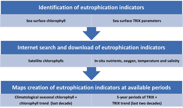
Freely online available data, i.e., public data sets, for eutrophication indicators from the last decade* was searched and collected to assess the level of Mediterranean Sea eutrophication.
Eutrophication indicators or variables which allowed the estimation of indicators were: surface chlorophyll pigment concentrations, nitrate, phosphate and dissolved oxygen concentrations, along with sea surface temperature and salinity.
Maps of chlorophyll concentration, seasonal climatologies, and trend, along with maps of the average TRIX indices and TRIX trend, were created.
Data covering the last two decades* were processed only when data for the (target) last decade were limited and prevented estimating trends.
Data Sources
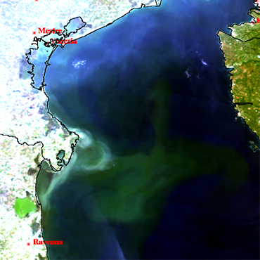
- Sea surface, satellite-derived chlorophyll pigment concentration in the water column (from Marine Copernicus).
- Sea surface in-situ nitrate, phosphate and dissolved oxygen concentrations along with temperature and salinity data (from EMODnet, NOAA, Perseus FP7 project and MedAtlas).
Targeted Products
Final Challenge Report: MedSea Checkpoint Challenge 6 (Marine Environment): Description of Targeted Products, the methodology and the expert evaluation of fitness for purpose.
How to Cite: “Cruzado, A., Bahamon, N., Falcini, F., Sammartino, M., & Simoncelli, S. (2017). EMODnet MedSea CheckPoint Challenge 6 (Marine Environment) Report. European Marine Observation and Data Network. https://doi.org/10.25423/cmcc/medsea_checkpoint_challenge6“
Team Involved
Antonio Cruzado (Oceans.cat), Nixon Bahamon (Oceans.cat) ,Federico Falcini (CNR)