The International Oceanographic Data and Information Exchange (IODE) of the Intergovernmental Oceanographic Commission (IOC) of UNESCO has awarded the Ocean Best Practices System Endorsement Certificate to EMODnet Chemistry’s Guide for the management of microlitter datasets. These data, along with the data on beach and seafloor litter, were used to produce the latest marine litter data collections downloadable from the EMODnet Products Catalogue. The collections in turn are used to create the maps; their latest edition was recently published in the EMODnet Map Viewer.
The EMODnet Chemistry partnership celebrates two important results.
Firstly, the guideline entitled ‘EMODnet Chemistry Guidelines and formats for gathering and management of micro-litter data sets on a European scale (floating and sediment micro-litter)’ has received the Endorsement Certificate of the Ocean Best Practices System (OBPS). The OBPS is the searchable repository for ocean best practices founded by the International Oceanographic Data and Information Exchange (IODE) of the Intergovernmental Oceanographic Commission (IOC) of UNESCO. As specified in the endorsement documents: "The aim of endorsement is for recognized ocean organizations to follow a systematic process for community inputs to their practices and sufficient practice documentation to share methods leading to uptake by the broader ocean community."
Secondly, the latest version of the maps visualising the spatial and temporal distribution of marine litter is available on the EMODnet map viewer. It contains 18 maps for beach litter, 9 maps for seafloor litter and 15 maps for floating microlitter (Figure 1). These data products are based on the latest data collections published in 2024, and downloadable from the EMODnet Product Catalogue.
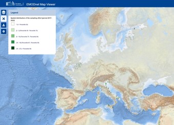
Figure 1. Floating microlitter data: Spatial distribution of the sampling effort (period 2017-2022) ©EMODnet Chemistry
EMODnet began managing data on marine litter on beaches and the seafloor in 2016. The corresponding pan-European centralised marine litter databases (MLDBs) were released in 2017. They were developed in collaboration with technical groups and regional conventions and built on existing protocols, networks and data systems. The beach litter database has been used for various assessments and reports, including the EU coastlines macro litter trends and the compilation of EU marine litter baselines (MSFD). In 2021, EMODnet Chemistry started working on microlitter data, for which there was no coordinated effort at regional or European level, resulting in a rather fragmented and heterogeneous management system. Given this situation, EMODnet Chemistry has involved the SeaDataNet network of national oceanographic data centres to collect data on floating microlitter and in sediment. In addition, special SeaDataNet data transport formats have been developed.
Back to the new maps, let’s look at the process that led to their publication. This came after the EMODnet Chemistry board of experts on the MSFD approved some changes to the maps published in 2023. These changes were proposed during the meeting on 24 March 2025 to present the new and updated visualisations for marine litter and to gather feedback for improvements from the MSFD Expert Board. Neil Holdsworth from the International Council for the Exploration of the Sea (ICES), EMODnet Chemistry's partner, chaired the meeting as this expert consultation is part of ICES' commitment to ensure the implementation of EU legislation and wider open data initiatives through interaction with key stakeholders. Visit the EMODnet portal for more information on the MSFD Expert Board.
During the meeting, OGS, the coordinator of EMODnet Chemistry, and IFREMER, a key partner of EMODnet Chemistry and responsible for producing the marine litter maps, explained the process used to produce the data products, including the quality assurance steps used for the recent updates of the marine litter datasets and map products.
François Gaudin from IFREMER informs that the existing litter maps for beaches and seafloor litter have been updated by integrating the Join list of litter categories for the monitoring of marine macro-litter. The maps for floating microlitter have also been updated to reflect international standard units and changes in vocabularies and to integrate a new methodological document into the metadata. For both floating microlitter and seafloor litter, he also proposed to add the map type for the spatial distribution of sampling effort over the last 6-year period for which data are available, reflecting an MSFD assessment period.
The experts agreed on the proposal and gave useful advice to improve the understanding and usability of the maps. It was also agreed that the new floating microlitter and seafloor sampling effort distribution maps could potentially be used for decision makers of monitoring programmes at regional or national level to assess spatial/temporal gaps in their marine litter sampling effort.
Explore the maps in the EMODnet map viewer and find out more in the EMODnet Product Catalogue.
“The most satisfying aspect of this work is knowing that the EMODnet Map Viewer allows a quick visual display and easy access to harmonised, validated and filtered data that users can download to study marine litter at regional/sub-regional or more local scales, make comparisons, calculate tendencies, cross with other data, etc. The new products on the distribution of the spatial effort could also be of interest for scientists and decision-makers in deploying future monitoring strategies, maintaining those already in place and/or reviving abandoned surveys. I was pleased to note that the great majority of the MSFD board of experts found these new maps very useful. The dialogue we had also reinforced the necessity of proposing up-to-date documents detailing the methodologies we adopted for beach litter, floating micro-litter and seafloor litter.”François Gaudin, IFREMER, EMODnet Chemistry Partner