Improved knowledge of coastal response to marine processes (resilience) and risk of coastal change (vulnerability) is crucial for coastal management in response to climate change. The new EMODnet Geology coastal resilience/vulnerability data product is a pan-European visualization, at variable scales, derived from a database of > 900 studies. Lower, intermediate and higher levels of coastline resilience/vulnerability are shown, with information on the wide range of methodological approaches used in their assessment indicating that geology and coastline shape (geomorphology) are key factors.
Improved knowledge of coastal resilience and vulnerability is crucial for sustainably governing and managing the coast. The new EMODnet Geology coastal resilience/vulnerability data product provides a map visualization at various scales, indicating lower, intermediate, and higher levels of coastline resilience/vulnerability to erosion and flooding. It is underpinned by a detailed review of >900 studies of coastal hazard, risk, resilience and vulnerability conducted across the shorelines of Europe and North Africa, the first time such a large dataset has been consolidated in a user-friendly map. Details of the wide range of methods used to assess coastal resilience and vulnerability are also accessible on the platform.
‘This new EMODnet geology map is the first time such a large dataset of coastal resilience/vulnerability studies have been consolidated and visualized in a user-friendly map. It highlights regional patterns, and the wide range of approaches used to assess coastal resilience/vulnerability. Complementing existing EMODnet geology maps of coastal migration and type, it contributes new insights for improving the resilience of coastal communities.’ Dr Ad van der Spek, coastal and marine geologist, TNO Geological Survey of the Netherlands.
Resilience is a measure of a system’s ability to withstand, and recover from, a major disruption. In coastal systems such major disruptions are often associated with external drivers such as wave impact and marine flooding, usually linked with storms and sea-level rise. But internal drivers, including the strength properties of coastal materials (geology), and the shape of the coastal ribbon (geomorphology), also determine the sensitivity of the coastline to change and are key in influencing its resilience. Coastal resilience can be considered as the ability of a coastline to absorb and recover from erosion or flooding before a critical state, that may require intervention, is reached.
Vulnerability is a measure of the susceptibility of a system to change. The greater the resilience, the lower the susceptibility and, therefore, vulnerability to change. Coastal vulnerability is a function of geological and geomorphological controls on resilience, alongside marine, ecological and socio-economic factors. Assessing coastal resilience/vulnerability is an important step in informing sustainable governance and management of the coast to build adaptive capacity at multiple scales for resilient coastal communities1.
With input from all EMODnet Geology partners, we have developed the most complete inventory to date of case studies on coastal vulnerability, including studies that focus on related issues: coastal hazard, risk and resilience. The literature database includes scientific journal articles as well as national databases and reports for the EMODnet Geology coastline. These data are integrated into a shoreline GIS file containing one of three classes of coastal resilience and vulnerability, classified as lower, intermediate or higher. A ‘no data’ class is defined to indicate where data are not currently available or openly accessible. The underpinning GIS file, produced by Edge Hill University, UK, was processed by TNO, the Netherlands, to visualize the data at different zoom levels, enabling the user to view and interpret data at a range of scales. The zoom levels represent point layers with average class categories of the shoreline underneath to give a regional overview of the coastal resilience and vulnerability as shown in the image.
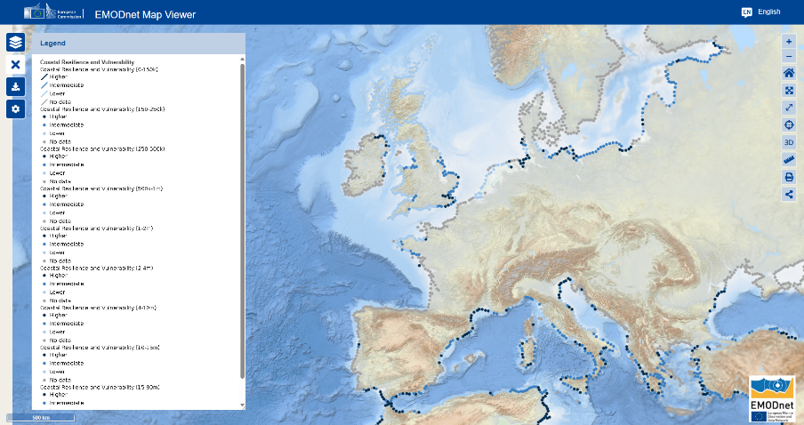
Map of Europe showing lower, intermediate and higher levels of coastal resilience/vulnerability derived from available data © EMODnet Geology
The new data product provides a tool for users who are interested not only in the pan-European distribution of coastal resilience and vulnerability, but also in the wide range of methodological approaches used in their assessment.
1Villasante, S., Richter, K., Bailey, J., Blenckner, T., Farrell, E., Mongruel, R., Timmermann, K., Bouma, T., Melaku Canu, D., Chen, M., Lachs, L., Payo, A., Sousa Pinto, I. (2023) Building Coastal Resilience in Europe. Alexander, B., Muñiz Piniella, A., Kellett, P., Rodriguez Perez, A., Van Elslander, J., Bayo Ruiz, F., Heymans, J. J. [Eds.] Position Paper N°. 27 of the European Marine Board, Ostend, Belgium. 126pp. ISSN: 0167-9309. ISBN: 9789464206197. DOI: 10.5281/zenodo.8224055
