We’re delighted to announce the release of a new data product available on EMODnet Human Activities: traffic density maps. Based on AIS data from ships, these maps were prepared by the European Maritime Safety Agency (EMSA) in response to a series of ad-hoc requests to complement specific studies or projects.
As EMODnet marks 10 years since its initiation in 2009, experts from EMODnet and across the global ocean observation, monitoring and data communities were in Hawai’i for the decadal Conference OceanObs’19. In its third edition, OceanObs’19 has expanded to 1500 participants, with 2480 authors contributing to 128 Community White Papers, 600 posters and 60 exhibits from academia, industry and management, all at the Hawai’i Convention Center, Honolulu.
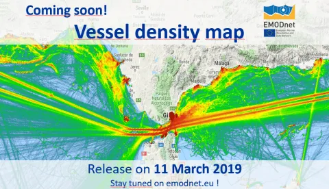
In March 2017, EMODnet Human Activities was mandated to create vessel density maps of EU waters showing the average number of vessels of certain type (cargo, passenger, fishing etc.) in a given period within a grid cell. Vessel density maps are by far the most requested GIS data product by EMODnet Human Activities users, according to a survey carried out in 2016. The maps went live on EMODnet Human activities for visualisation and download on 11 March 2019.
For the first time those responsible for monitoring shipping emissions, identifying the best routes to lay pipelines and cables, assessing the impact of fishing on the seafloor or planning offshore wind farms can have free and open access to maps and the underlying raster files of vessel activity.
The new EMODnet digital vessel density maps, released today, allows users to visualise vessel movement patterns and the distribution of maritime traffic in European waters.
As we do every year in January, we take stock of what we have achieved the previous year and look forward to what you can expect from us in the coming year. This time we have many updates for you as 2018 was a very productive year for EMODnet, with many achievements in the first full year of the third phase of EMODnet development (2017-2020).