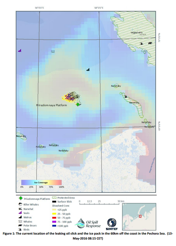
At 10:27 (BST) on 10/05/2016, the Arctic Checkpoint was alerted that an explosion had occurred at 08:15 (CET) on the Prirazlomnaya Platform, 60 km off the coast in the Pechora Sea. Oil was leaking subsurface, at a rate of 800m³/day: this is expected to be reduced to 500 m³/day following emergency repairs within 24 hours, with the leak being stopped completely within 72 hours.
Initial modelling was carried out using RPS ASA’s 2D OILMAPTM model. Because of the entrainment of the oil in the ice, the hydrodynamic data was made equal to the ice velocity fields and wind action has been switched off. Forecast Modelling on the 12th May and 13th May were carried out using SINTEF’s 3D OSCAR model that provides additional information about the oil in the water column. Metocean data was sourced from The Met.no website. A long range forecast (out to six months) was carried out using the Lagrangian particle-tracking software package, Ariane in conjunction with a 20 year output from the leading edge 1/12th degree resolution NEMO ocean model coupled to LIM2 ice model.

The oil spill was in a complex, ice infested environment that reduces the reliability of any oil spill forecast. In this case, the Prirazlomnaya Platform was in pack ice flowing westward at upto 0.5 m/s. The oil, which is lighter than water, can be expected to rise to the underside of the ice pack where it will be trapped into the moving ice sheet. During the first 72 hours, more and more oil was transported north-westward as the ice sheet flowed over the top of where the leak wass. The ice pack was currently breaking up, making an accurate prediction of where the oil can be recovered very difficult.

Please follow the links below to find the bulletins produced 24, 48 and 72 hours after the spill:
All Sea Basin Checkpoints performed this stress test. A summary of results can be found at the Martime Forum.
The unannounced exercise was a challenging scenario that included ice covered waters. As early as 1979, an experimental scientific release of oil and gas under ice was conducted in order to be better prepared for a well blowout under ice. The T/V Kurdistan oil spill occurred in 1979, spilling approximately 7000 tons of bunker C into ice infested waters in Cabot Strait. Other published oil spills in ice covered waters are the Runner 4 in the Gulf of Finland (2006) and the Godafoss in Norway (2011). Only through continued research and preparedness exercises can the community of scientists, responders and Decision Makers have the best knowledge and tools within their immediate reach in order to best respond to oil spills.
Why?
Because Spills of National Significance are not all alike, and our scientific knowledge and technology continues to advance: see the new capping stack for subsurface well blowouts from the Deepwater Horizon oil spill.
The SINTEF and OSRL teams combined have decades of experience with research/experimental oil spills and with accidental oil spills in open water and in ice covered waters. Those active on the exercise have experience with spill drills and oil spill responses: counting real spills in the hundreds, including the Deepwater Horizon. The EU Seabasins Checkpoint Arctic was an opportunity for the two teams to focus on gathering historical information, connect modeling systems to key forecasting systems for winds, currents and ice, and pull together natural resources at risk. Each time we do this, we learn something: new data is available in real-time and new research may be applicable. Preparedness is continuous learning and practice in order to create quality integrated systems for prediction and analysis.
Did you know that subsurface dispersant application was first tried in the 1969 Santa Barbara oil spill?
The Deepwater Horizon is the second confirmed application of chemical dispersant, in that case the initiation of Subsurface Dispersant Injection (SSDI). Through continued research since 2010, we are close to having the capability to control and monitor the oil droplet size distribution resulting from SSDI in near-real time. Controlling the droplet size distribution in turn controls where the oil goes (ocean surface or remaining the ocean to biodegrade), so responders can best apply the suite of response options (mechanical recovery, chemical dispersants, in situ burns) toward the best outcome for the environment and ecosystem as a whole.

