
EMODnet Data Ingestion seeks to identify, reach out and give support to potential data providers to ingest their marine datasets for further processing, publishing as open data and contributing to practical applications for society through EMODnet. These can concern research institutes, governmental organisations, companies, and NGOs who collected and manage marine and ocean data sets for many purposes, such as research, environmental management, engineering projects, EU Research Projects, offshore license procedures, and many others. EMODnet Data Ingestion streamlines the data ingestion process from data release to safekeeping and subsequent distribution through EMODnet. This also concerns operational oceanography data streams from monitoring platforms and initiatives. EMODnet Ingestion works together with each of the EMODnet thematic groups who might use the data as extra input for their added-value products and services.
The EMODnet Data Ingestion Service is temporarily unavailable. It will be resumed in the coming weeks.
All other EMODnet services remain operational.
You can contact the EMODnet (technical) Helpdesk at: helpdesk@emodnet.ec.europa.eu
We apologise for the inconvenience.
Objectives
EMODnet Data Ingestion aims:
- To identify and reach out to organisations from public, research and private sectors who are managing marine datasets for bathymetry, geology, physics, seabed habitats, chemistry, biology and/or human activities and who are not yet connected and contributing to the existing European marine data management infrastructures
- To motivate and support those potential data providers to contribute to EMODnet
- To facilitate the inclusion and harmonisation of those marine datasets, with standardised and complete metadata, in the EMODnet data, data services and products.
Approach
Rapid access to reliable and accurate marine data and information is vital for addressing threats to the marine environment, for the development of policies and legislation to protect vulnerable coastal and oceanic areas, for supporting evidence-based research to understand the complexity of marine ecosystems and their evolutions, and for forecasting future changes. Likewise, better quality and more easily accessible marine data is a prerequisite for further sustainable economic development, so-called ‘blue growth’, and to achieve the ambitious targets of the EU Green Deal and EU Mission: Restore our Ocean and Waters.
For their data throughput, the EMODnet thematic groups rely on and interact with European marine data infrastructures such as SeaDataNet, EurOBIS, EGDI, ICES, and others. Their data centres offer validation, long term stewardship, and FAIR documentation, following agreed community standards, for data, observed by currently more than a thousand data originators from public, research and private sectors in the European marine data landscape. From these data sets, EMODnet experts create pan-European thematic data products that are fully open and accessible for use such as the Bathymetry Digital Terrain Model, EUSeaMap broad-scale seabed habitat map for European seas, Vessel Density composite maps, and others.
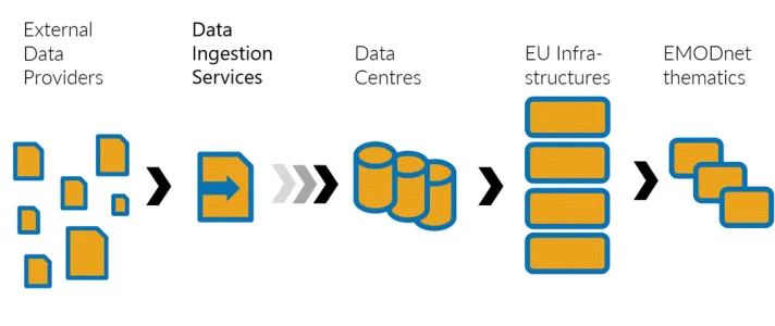
EMODnet Data Ingestion adds an extra component to the existing pathways for data towards EMODnet thematic groups. It provides services and support for new data providers to ingest and make their data sets available and fit for use by EMODnet thematics, which then can use the data as additional input for generating EMODnet data products and services. For this purpose, EMODnet Ingestion operates a large network of data centres, experts in managing specific data types and which are connected to the European data management infrastructures that feed the EMODnet thematic groups. This is illustrated in the image below.
EMODnet Data Ingestion supports data providers with:
- An online Data Submission service to submit marine dataset packages including metadata description, which then can be processed together with expert data centres from the EMODnet Ingestion network;
- Guidance about formats and tools to be used by data providers for making their metadata and data fit for uptake in the European marine data management infrastructures, which feed EMODnet thematic groups;
- Facilitating inclusion of operational oceanography data streams in the European data exchange organised by EMODnet Physics with EuroGOOS, Copernicus Marine Service, and SeaDataNet;
- Publishing submitted multi disciplinary data sets and operational oceanography data streams at the EMODnet Portal.
A distinction is made between 2 phases in the life cycle of a data submission
- Phase I: from data submission to publishing of the submitted datasets package ‘as is’;
- Phase II: further elaboration of the datasets package and integration (of subsets) in national, European and EMODnet thematic infrastructures.
The same distinction is also made for operational oceanography data streams, where metadata and data from monitoring platforms, once connected, are published ‘as-is’ in Phase I, while Phase II includes elaboration of metadata and data to the common standards as used for better documentation, harmonisation, and interoperability to achieve FAIRness.
Services
EMODnet Data Ingestion provides a range of services and functionalities to data providers for ingesting their metadata and data and includes these in the data pools that are used by EMODnet thematic groups for generating and publishing EMODnet data products and services. Moreover, there are services provided for users to find and download the ingested data sets. Currently the following key services and functionality are provided:
- Data Submission Service provides online functionality to data providers to prepare and submit metadata and data packages;
- Ingesting Operational Oceanography data streams to facilitate operators of operational oceanography platforms and networks to connect to the European operational oceanography exchange;
- EMODnet Products Catalogue Service allows data providers and users to find the submissions that have been published, to browse their metadata, and to download the associated data sets;
- EMODnet Map Viewer Service provides functionality to view maps with locations of the operational oceanography stations that have been connected through EMODnet Ingestion as part of the European operational oceanography data exchange, to retrieve metadata about these observations and to download the associated data sets.
Data Submission Service
EMODnet Data Ingestion focuses on data providers and their data sets that are not yet handled and part of the mainstream arrangements and data handling processes of the EMODnet Data Centres. The latter are National Oceanographic Data Centres (NODC), National Geological Surveys, Biology Institutes, and National Hydrographic Agencies in European countries.

The EMODnet Data Ingestion Service is temporarily unavailable. It will be resumed in the coming weeks.
All other EMODnet services remain operational.
You can contact the EMODnet (technical) Helpdesk at: helpdesk@emodnet.ec.europa.eu
We apologise for the inconvenience.
Details about the submission workflow and the metadata elements of the submission form can be found in the Data Submission form elements document.
The online Data Submission service provides an easy means for potential data providers to submit marine dataset packages, that they have collected and are managing. Each package should consist of a collection of datasets and relevant documentation, accompanied with a clear submission form of metadata describing the datasets collection.
Potential data providers are marine data holders that are not yet routinely submitting data sets to national data centres and not (yet) used to practices and standards as used by the international marine data management community. To ease the process of submission, completion of the submission form is shared between the data submitter (part 1) and the data centre (part 2) that is processing the submission.
As data submitter you are asked to complete Part 1 of the submission form with key metadata and to upload your datasets as a zip package. Please include also relevant documentation on the in-situ observation activity, applied quality assurance, if relevant, specification of formats (data and metadata), for optimal review and elaboration of your submission for publishing by the assigned data centre.
The data centre is a member of the EMODnet Ingestion network and will review and complete Part 2 of the submission form consisting in a number of additional metadata fields. A data tracking service is integrated in the Data Submission service to allow data submitters to follow up the submission process and to ease communications between data centre and data submitter in case of questions or needs for clarification.
Tips for data submitters:
- The submission should concern datasets for observations and/or analysed samples together with documentation and not just stand-alone reports. Furthermore, you are encouraged to submit data packages which rather concern collections of datasets, for example resulting from a project, cruise, monitoring programme etc., and not individual datasets. Do not forget to include relevant documentation too in the zip package that you submit.
- You are advised not to upload too large data collections per data package because of upload performances, but also to restrict having too many different data sets in a data package. Therefore, you might divide data packages at least by theme and possibly by observation methods in order to get smaller and more harmonised data packages. This implies that you should build series of data packages for specific projects which will be beneficial for the further processing and uptake in data repositories.
- Most submission metadata fields are supported by SeaDataNet controlled vocabularies while allowing also free text entries. In those cases, you are urged to use existing terms and only to enter free text if you cannot find the relevant terms.
- The assigned data centre will review and curate your data submission in order to make these fit for long term storage and stewardship in their data management system and to share it with the appropriate EMODnet thematic group. However, there is a great variety of data types and formats around and as demonstrated in the regular practice of the data centres, it can take significant human efforts and time for processing, validating, converting and documenting of incoming data sets. To ease and accelerate or even to make this process feasible, data submitters are encouraged to adopt common formats for metadata and data for the submitted datasets. Guidance information can be found under the section Marine Data Management Guidelines.
How to register as data submitter
The EMODnet Portal is public domain. However, a user registration is required for data users to act as a data submitter for using the Data Submission service with its range of functions. The user registration is required to ensure that data submitters have a unique logon which will be instrumental for managing their submissions and for tracking the processing of their submissions. As part of the registration, data submitters will need to agree with the terms of use of the EU ECAS service that is used by EMODnet Data Ingestion for user registration, authentication and authorisation.
Data submitters must register once in the EU ECAS system in order to get a personal logon name and password. This is done by filling a web form and confirming that the user accepts the terms of use.
How will your datasets be processed and published
Completed submission form and dataset package will be stored in the EMODnet Data Ingestion cloud infrastructure with a unique ticket number (UUID) allowing further monitoring and managing of the submission.
The EMODnet Ingestion managers will do a first quality check and assign a data centre that is the best suited for further processing. The data centre will undertake further processing and publishing following 2 phases in the life cycle of the data submission:
- Phase I: from data submission to publishing of the submitted datasets package ‘as is’;
- Phase II: further elaboration of the datasets package and integration (of subsets) in national and European data infrastructures and the EMODnet portal.
The workflow process from data submission to publishing of the submitted data package during both phases is illustrated below.
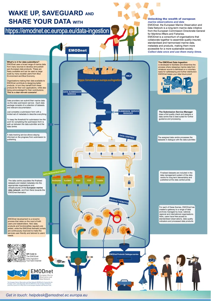
Phase I: the assigned data centre will review the submitted metadata and datasets package (datasets collection and associated documentation) and complete the submission form with extra metadata. There will be contact with the data submitter in case of questions. Once ready, the data centre will request approval of the data submitter for publishing the complete submission form and the original data package ‘as is’. The data submitter then has 2 weeks for a response; otherwise, approval is given automatically. Once the metadata is fully agreed, the submission form and dataset package will be released for publishing. This will take place by means of the EMODnet Products Catalogue service. Using this service any user can search the submission forms and download the related dataset packages ‘as is’ without any restrictions. The data submitter can follow the process via the tracking information in the submission form.
Phase II: The datasets package will be further processed and curated by the assigned data centre, in dialogue with the data submitter, in order to make it, or its subsets, fit for long term storage and stewardship in their data management system, and to share it with the appropriate European infrastructure (SeaDataNet, EurOBIS, EGDI, ICES, COGEA) and EMODnet thematic group(s). The validation and processing of data submissions will be made easier and more straightforward if data submitters already apply standard data formats to their datasets collections and also provide relevant documentation as part of their submissions. Those measures will greatly optimise the efforts and time needed for Phases I and II. Therefore, data submitters are advised to read the marine data management guidelines for different data types and for EU projects.
Finalised datasets (possibly subsets of the original data package) will be included in the data management system of the data centre for long term stewardship and published at the data centre portal. The national, European and EMODnet URLs will be added to the data submission form in the EMODnet Products Catalogue service, so that all links can be followed by users.
Also have a look at the Manual for Data Submitters, the Manual for Data Centres and the submission process overview .
All datasets submitted through the Submission service will be considered as open data.
The submitted datasets will be published with acknowledgements to data providers and data originators. In principle this will be at organisation level to respect privacy of data submitters. However, in case of specific requests by the data submitter, also names of researchers might be published, as this might be important for data citation purposes.
Internally the Submission service works with contact details of data submitters and assigned data centres in order to allow for direct communication relevant for processing the submitted datasets. These personal details will not be published.
How can you track the processing
The data submission process has a dedicated workflow, decribed above, with interactions between the data submitter and the assigned data centre. Both data submitters and data centres can track the progress of completing the submission form and data package upload by means of a ‘Process Info’ section in each submission form.
What are the conditions of use of submitted data sets
Data sets are included and published in EMODnet by data submitters on behalf of data originators, who own the intellectual property rights of the data sets. Users are granted a non-exclusive and non-transferable right to retrieve and use these data sets under the following terms:
- Retrieval, by electronic download, and the use of data sets is free of charge;
- Regardless of whether the data are quality controlled or not, EMODnet, data submitters and data originators do not accept any liability for the correctness and/or appropriate interpretation of the data. Interpretation should follow scientific rules and is always the user’s responsibility. Correct and appropriate data interpretation is solely the responsibility of data users;
- Users must acknowledge data sources when publishing by referring to the data sets in EMODnet which give proper attribution of data originators;
- Users should not give the data sets to third parties, but rather inform them about how to find and get the data sets at EMODnet.
Where possible, ingested data sets are further processed and elaborated by expert data centres. Finalised data sets (possibly subsets of the original data package) will be included in the data management system of the data centre for long term stewardship. Action will be undertaken to populate the finalised curated datasets and related metadata into the appropriate European infrastructures (SeaDataNet, EurOBIS, EGDI, ICES, COGEA) and from there towards the EMODnet portal. Each of these infrastructures make use of their own data policies; however, the core conditions of use are comparable to those listed above for EMODnet.
Ingesting Operational Oceanography data streams
EMODnet Ingestion aims at making marine data part of the European data management infrastructures. This concerns marine data from the European seas and coastal waters from diverse governmental, research and private sources. It concerns data that have been collected by all kinds of surveys, campaigns, and projects. It also concerns operational oceanography that is the systematic and long-term routine measurements, interpretation and dissemination of the ocean (and atmosphere) data. These data are collected by fixed and moving platforms such as fixed stations, moorings, buoys, tide gauges, surface drifters, ferryboxes, argo floats, gliders, HF radars and other platforms.
For operational oceanography, EMODnet Ingestion works closely together with EMODnet Physics. Operational data are made available in the EMODnet Map Viewing service with map layers under EMODnet Physics and EMODnet Ingestion. This is particularly important to provide users a single place where to see what, where, how is collected at the sea as well as to reduce duplication of effort among agencies, to improve quality and reduce costs related to geographic information, thus making oceanographic data more accessible to the public and helping to establish key partnerships to increase data availability.
Currently, EMODnet provides access in the EMODnet Map Viewing service to data timeseries of more than 200.000 platforms. Each platform may provide one or more physical parameters of the sea, namely sea surface temperature, temperature in the water body column, sea surface salinity, sea salinity in the water column, sea surface currents, sea level, wave direction, wave peak, waves frequency, atmospheric pressure at sea level, sea turbidity, and chlorophyll(a). EMODnet is also offering a unique and valuable product on rivers outflow timeseries.
Operators of physical oceanography monitoring platforms that are not yet available in the EMODnet portal are encouraged to get connected and make their data streams available in near real time, as monthly time series, and as archived and validated long timeseries.
The connection of near real time data flow towards EMODnet is split into two distinct phases:
- An inclusion of the source “as is” (phase one). This includes and exploits machine-to-machine technologies ranging from the use of FTP file access to web APIs for RT exchange, to the adoption of a Data Access Broker (DAB) service, and to the adoption of ERDDAP. Phase 1 is achieved once a new operational data source is ingested into the data layer and a data-collection is added to the ingestion ERDDAP data server.
- The next step is the inclusion of the source into a harmonized and validated data collection (phase two) for long term stewardship. This depends on data centres assessing the added-value of the submitted data and the efforts needed for elaborating their operational data output to common formats, if anyhow possible. Elaboration includes activities like review, validation, conversions to standard formats, and further population to the relevant European or global infrastructures such as Copernicus Marine Service In Situ TAC, SeaDataNet, ICES database and others, depending of the theme, the platform, and the provider. This step requires further elaboration, and data and metadata harmonization and may not always be possible.
For operational and (near) real-time connections, use can be made of ERDDAP. An EMODnet docker package is available to organizations interested in adopting this as connector. See the GitHub page.
The GitHub also includes a preliminary version of a light and easy installable mapviewer that consumes data from the ERDDAP docker. In other words, if the provider installs the docker following the provided examples/templates, he can also install this light mapviewer and see its data from a local interface that can easily adapted and expanded for internal purpose. This way the provider can deploy its own mapviewer and at the same time is adopting standards that facilitate immediate interoperability towards EMODnet Ingestion. See the GitHub page for the map viewer.
Are you interested to adopt ERDDAP and connect your operational data streams to the RT pilot, then contact us.
The European operational oceanography data exchange and the Marine In situ Collaboration
Governmental agencies and research institutes are managing physical oceanography observation systems and take care of the first level of data processing for their own applications. An organisation collects, controls and distributes data in principle according to its own rules. However, the development of Operational Oceanography at regional and global scales involves major investments which are difficult to be made by a single country. Active cooperation has thus always been a key issue for the development of the Global Ocean Observation System (GOOS) towards the development of a global ocean observing system truly responsive to the needs of end users, able to mitigate mounting pressures on the ocean and enable resilient and sustainable blue economies. GOOS is organized in Regional Alliance (GRA), GRAs are particularly important for incorporating both coastal and open ocean observations, and for engaging with the users of operational services and the beneficiaries of marine ecosystem health.
The European component of the GOOS is EuroGOOS that serves 48 members and supporting five regional systems in Europe. EuroGOOS working groups, networks of observing platforms (task teams), and regional systems (ROOS), provide fora for cooperation, unlock quality marine data and deliver common strategies, priorities and standards towards the European Marine Services. EuroGOOS acts as a pillar for streamlining the operational data flow towards the Copernicus Marine Service (In Situ TAC) and EMODnet Physics.
The Copernicus Marine Service In Situ Thematic Assembly Center is a component of the Copernicus Marine Service and it gathers and bundles the in situ observations from the EuroGOOS ROOSs and from international operational networks and processes these into quality controlled data collections to serve Copernicus Marine Service operational marine forecasting components. The Copernicus Marine Service INS TAC cooperates with EMODnet Physics on the operational data collection and provision.
SeaDataNet is a pan-European network of professional data centres providing on-line integrated databases of standardised quality and developing and promoting standards for marine data management. It is developing and operating an infrastructure for managing, indexing and providing access to ocean and marine environmental data sets and data products (e.g. physical, chemical, geological, and biological properties) and for safeguarding the long term archival and stewardship of these data sets. Data resources are quality controlled and managed at distributed data centres that are interconnected by the SeaDataNet infrastructure and accessible for users through an integrated portal. The data centres are mostly National Oceanographic Data Centres (NODCs). In the context of the EMODnet Physics goals, SeaDataNet arranges the provision of archived and further validated long time series of oceanography data.
In this framework, the MIC -Marine In situ Collaboration- has been established, formed by members of EMODnet (Ingestion, Physics, Chemistry) Copernicus Marine Service INSTAC, EuroGOOS, SeaDataNet, to identify and gather new in-situ datasets and in-situ data providers to support EMODnet, Copernicus Marine Service and international initiatives on Ocean Observations. The team aims to streamline a common ingestion procedure, to provide near real-time data to the operational community and facilitate its availability in National Oceanographic Data Centers and other official repositories for long-term stewardship of these valuable data.
The MIC team is actively working to make all operational in situ data accessible through EMODnet and to include all data relevant to Copernicus Marine Service into the INSTAC.
Once the operational data is linked in the EMODnet DB, the SeaDataNet network of NODCs might take over and undertake efforts for arranging the provision of archived and further validated long time series of oceanography data.
Products Catalogue Service for viewing published submissions
The completed data submissions (phase 1 and phase 2) are published in the EMODnet Products Catalogue Service. This service allows users to search, browse metadata, and download the datasets that have been submitted via the Submission service and that have been reviewed and completed in metadata by assigned data centers. In phase 1, these datasets are published “as-is”, while as phase 2 they will have been further inspected and elaborated, and taken up in national and European data infrastructures that are feeding EMODnet. These URLs are made available as part of the publishing.
Map Viewer Service for operational oceanography
Stations and data sets from operational oceanographic data providers that have been connected to EMODnet via the cooperation of EMODnet Physics and EMODnet Ingestion are published and made available in the EMODnet Map Viewing service. This is done by map layers which can be found under EMODnet Physics and EMODnet Ingestion. These maps provide users a geographical overview and access to further metadata and related data sets.
Marine Data Management Guidelines
Marine data include a very wide range of measurements and variables derived from a broad spectrum of multidisciplinary research projects and monitoring programmes. The data are collected by different institutes, governmental organizations or private companies using heterogeneous instruments and sensors installed in various observing platform. Depending on the data type, the acquisition systems, the delivery time frame or operations of the archiving centre, there is not a unique used data model and structure and the original measurement format may not be the same with the format that the archiving centre can accept. In general, the archiving format should:
- Be independent from the computer (and libraries),
- Ensure that any isolated data includes enough meta-data to be processed (eg. Location and date),
- Be compatible and include at least the mandatory fields (meta-data) requested for the exchange format(s),
- Include additional textual or standardized “history” or “comment” fields to prevent any loss of information,
- Provide similar structure and meta-data for different data type such as vertical profiles and time series.
Alongside the data, additional information (metadata) is needed not only for quality control and archiving, but also for exchanging data or integration of them into regional or global data sets. For all types of data, information is required about:
- What has been measured (parameters and units)
- Where the data were collected: location (preferably as latitude and longitude) and depth/height
- When the data were collected (date and time in UTC or clearly specified local time zone)
- How the data were collected (e.g. sampling methods, instrument types, analytical techniques)
- How you refer to the data (e.g. station numbers, cast numbers)
- Who collected the data, including name and institution of the data originator(s) and the principal investigator
- What has been done to the data (e.g. details of processing and calibrations applied, algorithms used to compute derived parameters)
- Watch points for other users of the data (e.g. problems encountered and comments on data quality)
The great variety of data submitters are strongly advised to adopt the common formats for metadata and data with the existing marine community practices and make use of these common standards for their data packages submissions. This will enable the easiest integration of their data sets into the current data systems and make them re-usable. A summary of these basic data management guidelines used by the marine community can be found under guidelines for different data types.
For the process and guidelines for managing operational data check the specific section.
See also the section on EMODnet Guidelines for European projects data submissions.
Guidelines for different data types
Data submitters are encouraged and strongly advised to adopt the common formats for metadata and data with the existing marine community practices and make use of these common standards for their data packages submissions. This will enable the easiest integration of their data sets into the current data systems and make them re-usable. These basic data management guidelines as used by the marine community are summarised below.
International Oceanographic Data and Information Exchange:
The main objective of the programme "International Oceanographic Data and Information Exchange" (IODE) of the "Intergovernmental Oceanographic Commission" (IOC) is to facilitate the exchange of oceanographic data and information between participating Member States. For that purpose, IODE maintains the IODE Ocean Data Practices repository that is a data and information management of best practices repository of community practices that enables those who are going to embark on a new project and need to prepare a data management plan, to look for methodology already used by other projects or data/information centres (“best practices”).
ICES Marine Data:
The ICES Data Centre accepts a wide variety of marine data and meta-data types into its databases that are used in various assessments for expert groups and regional sea conventions. In order to ensure comparable data with high quality, guidelines have been developed and adopted specific to the type of data and whether it is associated with a marine convention monitoring programme. Each guideline addresses the data and metadata requirements of a specific data type, targeted toward physical-chemical-biological data types collected on oceanographic research vessel cruises. They cover three main areas:
- What the data collector should provide to the data centre (e.g. collection information, processing, etc)
- How the data centre handles data supplied (e.g. value added, quality control, etc)
- What the data centre can provide in terms of data, referral services and expertise back to the data collector
Access the ICES guidelines.
SeaDataNet marine and oceanographic data standards:
SeaDataNet maintains and operates a Pan-European data management infrastructure for marine and oceanographic data and provides metadata discovery and data access services to the data holdings of a distributed network of more than 100 connected marine data centres from 35 countries. Specific data file formats have been developed and used for data exchange:
- SeaDataNet ODV4 ASCII for profiles, time series and trajectories,
- SeaDataNet NetCDF with CF compliance for profiles, time series and trajectories,
- SeaDataNet MedAtlas as optional extra format,
- NetCDF with CF compliance for 3D observation data such as ADCP.
Access here the manuals and guidelines on the data transport formats. In addition, there are available options and methods to connect to the infrastructure and contribute to its metadata discovery system.
EMODnet Chemistry - European Marine Litter database and formats:
EMODnet Chemistry has built and is maintaining the first pan European Marine Litter Database (MLDB). The MLDB stores and validates observation data sets for Beach Litter and Sea Floor Litter. The associated data formats, vocabularies and classifications have been formulated, following the advice of the MSFD Technical Group on Marine Litter. The data entries are retrieved from a variety of sources, including Regional Sea Conventions, EU Member States, EMODnet partners and a number of research or monitoring projects. A majority of data sets originates from monitoring projects (e.g. by OSPAR and ICES DATRAS).
The MLDB is a great step forwards in the gathering and harmonizing of Marine Litter data at European level. The MLDB has been actively used by EU JRC to compute EU Marine Beach Litter Baselines and EU Marine Beach Litter Thresholds. The MLDB is also used to generate derived data products, such as EMODnet Chemistry Marine Litter maps, which are published at the Map Viewer service of the EMODnet Portal, and to monitor Marine Litter in and along European seas.
In addition to the MLDB, EMODnet Chemistry gathers, manages, and publishes data of Floating Micro Litter, which are retrieved from EMODnet partners and research projects.
Access the Marine Litter guidelines for gathering and formatting Marine Litter data (beach litter, sea floor litter, micro litter).
All gathered Marine Litter data sets are made accessible through the CDI Data Discovery and Access service of EMODnet Chemistry . The data are available for downloading in the EMODnet Chemistry formats, depending on the specific sharing policy (public /restricted) applied by the originator.
Reporting on Marine Spatial Planning (MSP) information by Member States:
EU DG-MARE aims at building an EU-wide dataset on Marine Spatial Planning (MSP), that are published and made available as part of EMODnet Human Activities. The data set represents the marine spatial plans adopted by the Member States following the Directive 2014/89/EU. This requires gathering of information on national MSP plans. Therefore, Member States are encouraged to make use of the Submission service of EMODnet Ingestion for submitting their information. The following Guidance Document gives further information on the procedure and advised data model for submission.
European Ocean Biogeographic Information System (EurOBIS):
The European Ocean Biogeographic Information System – EurOBIS – is an online marine biodiversity database compiling data on all marine biota. It is a core service in EMODnet Biology. The principle aims of EurOBIS are to centralize the largely scattered biodiversity data on marine species collected by European institutions or European projects and researchers collecting data outside European waters and to make these data freely available and easily accessible. Integration and quality control of biodiversity data from many different sources requires a minimum of standardization and quality control before sound and useful integration becomes possible. EurOBIS follows a number of international standards and runs a number of quality control procedures on each received dataset, in order to be able to estimate the quality of the provided data and to define the fitness for purpose of the data for our various users. Access the basic overview of the standards and basic quality control (QC) procedures and standards.
Data can be submitted using different data formats. The accepted data formats are:
- Excel spreadsheet (.xls, .xlsx)
- Access database (.mdb, .accdb)
- Comma/tab separated values (.csv)
- Text file (.txt)
Data providers (especially those from EU funded HORIZON projects) are encouraged to submit their data in DwC format. A file template, in excel, is available for data providers. A self-paced, free online training course is also available for data providers and will guide you through all the steps required to create a DwC file and perform quality control. The quality control can be done on data tables (files) by the use of an R package which is available on the EMODnet GitHub .
This webpage gives more information on the EurOBIS data formats.
Marine Environmental Data and Information Network (MEDIN):
MEDIN is a partnership of UK organisations committed to improving access to marine data and easier data sharing. MEDIN Data Guidelines provide a list of information that should be collected with the data to ensure they can be re-used in the future. The guidelines are tailored to different methods and are arranged by theme aiming to improve interoperability between organizations by providing a format which can be used to import and export data.
Access the MEDIN data guidelines including details of formats.
MEDIN Submission guidelines for geology, geophysics and backscatter are managed by the British Geological Survey. For geosciences and related disciplines, a webpage is available regarding data information on how to deposit data at the NERC National Geoscience Data Centre (NGDC).
International Hydrographic Organization (IHO):
Standardisation of hydrographic methods and the provision of information is a fundamental part of achieving the IHO objectives. The Organization began developing standards and guidelines intended for use by the wide community of professionals with responsibilities in the fields of hydrography, nautical cartography, safety of navigation and related matters.
IHO standards are compiled and maintained by various Working Groups made up of volunteer representatives from IHO Member States (usually from HOs), together with expert contributors representing industry and the various other stakeholder groups. Standards must be authorised by a majority of IHO Member States before they can enter into force.
Access the list of the IHO standards.
Guidelines for European projects data submissions
EMODnet Data Ingestion, in collaboration with EMODnet Thematic Coordinators and the Secretariat, have produced an EMODnet Guidance document on European project data submissions to EMODnet. This is an output from the webinar 'EMODnet for Horizon Europe and Mission: Restore our Ocean and Waters' on 28th February 2024, organised by EMODnet, in collaboration with EC DG MARE. Watch the video.
The new EMODnet guidance document is primarily aimed at European Research and Innovation projects that seek advice and guidelines on preparing and submitting data to EMODnet. It is designed to inform EU project data management plans, and to optimise the pipeline of marine knowledge from data collection and curation to submission into the EMODnet service, where Europe's in situ marine data capability is offered as pan-European FAIR data, data products and metadata, for open and free use by all. Read more about the webinar and guidance document.
Software tools
There is a vast range of software tools, both open and commercial licenses, that can be applied for formatting and quality checking of marine data types. The following listing gives an initial overview.
ICES Marine Data Tools:
ICES offers a rich collection of applications, software, calculators and dictionaries that potential data providers may find useful either to work with the ICES data sets or for processing their data packages before submission. These tools range from web services for the expert data miner, to information on how the different data types are formatted for input into the ICES databases. Get access to the relevant tools.
SeaDataNet Tools:
SeaDataNet has developed a number of common tools to provide an integrated and harmonised overview and access to data resources, managed by distributed data centres. Software tools are, freely available to Data Centres and/or end users
SeaDataNet Data reformatting tools:
- OCTOPUS: a multi-format splitter and converter tool to to convert files in a given SeaDataNet format to another SeaDataNet format (e.g. : ODV to NetCDF, MedAtlas to NetCDF, MedAtlas to ODV)
- NEMO javatool: for conversion of any ASCII format to all SeaDataNet data formats (ODV ASCII, NetCDF (CF) and MedAtlas)
SeaDataNet Metadata reformatting tools:
- MIKADO javatool: for editing and generating XML metadata entries for the for the SeaDataNet directories EDMED, CSR, EDMERP, CDI and EDIOS.
- EndsAndBends: Tool for the generation of spatial objects from vessel navigation during observations
SeaDataNet Quality Controls Tools:
- Ocean Data View software package: adapted for quality control, analysis and visualizations of data sets
- DIVA software tool (Data-Interpolating Variational Analysis) allows to spatially interpolate (or analyse) observations on a regular grid. It can be used to compute error maps and to identify areas with poor coverage.
Integrated Publishing Toolkit (IPT) for biodiversity data:
Data can be submitted using different data formats (see data management guidelines). In addition, data can be prepared through the Integrated Publishing Toolkit (IPT) developed by GBIF. The IPT is a freely available open source web application that makes it easy to share biodiversity-related information. The user is guided by the application through a series of steps to format their data, fill in the necessary metadata and publish the dataset.
Offshore license procedures
EMODnet, the European Union's central hub for in situ data, data products, and services related to the ocean, marine, and coastal waters, plays a pivotal role in shaping the landscape of marine data practices within the European Union. A recent analysis conducted as part of EMODnet Ingestion, with a specific focus on offshore aquaculture and renewable energy activities, has revealed diverse approaches and practices related to the availability of marine datasets collected in the framework of offshore licenses. This diversity presents an excellent opportunity to refine our understanding and explore the feasibility of a more harmonized approach.
Therefore, EMODnet Ingestion has organized February 29, 2024, an online Workshop 'Data Management in Offshore Licensing Procedures', aimed at governmental stakeholders in offshore licensing procedures. The workshop focused specifically on advancing management practices across member states for marine data acquired in the framework of licensing.
Current Practices in Offshore Renewable Energy and Aquaculture Licensing were presented as use cases of offshore renewables by officials from Italy, Malta, Estonia, and United Kingdom and as use cases of offshore aquafarming by officials from Bulgaria and France. These were utilized to initiate discussions on the feasibility and desirability of a harmonized approach. During the discussion, it became apparent that the majority of the participants were in favour of a more harmonized approach for data management in offshore licensing procedures. They also agreed, that efforts for harmonization should primarily focus on the EU level. Only a limited number of participants indicated that the focus should be more on the national level. Furthermore, it was discussed which role EMODnet could play in supporting activities towards a harmonized approach.
The workshop served as a first step in exploring the opportunities for a more harmonized approach in data management within licensing procedures. The outcomes have been used as input to define the scope and activities of the next phase of the EMODnet Ingestion project. As part of this, a roadmap will be developed in co-creation with stakeholders to promote the harmonization of data management within offshore licensing procedures. This roadmap will be finalized and presented in the first quarter of 2026.
Read the short summary of the successful workshop.
Partnership
The EMODnet Data Ingestion activities are undertaken by a European network of 46 organisations from 29 coastal countries, including 1 international organisation. Geographically the network has nodes in the countries around all European marine basins and it covers all EMODnet data themes. Most partners are data centres and are qualified as National Oceanographic Data Centres (NODC), National Geological Surveys, Biology Institutes, or as National Hydrographic Agencies. Moreover, the consortium includes the coordinators of the EMODnet thematics through which also those networks are involved.
This list provides an overiew of the consortium.
By clicking on the names in the list you can call up more details of each partner from the European Directory of Marine Organisations (EDMO), managed by the SeaDataNet network. The consortium includes many national data centres. These are highly skilled and have been actively engaged in data management for many decades and have the essential capabilities and facilities for data quality control, long term stewardship, retrieval and distribution. They are actively involved in national research and monitoring activities and have established arrangements for managing the resulting data on a national and thematic basis. Furthermore, the data centres work together on a pan-European and international scales in organisations such as IODE, ICES, EuroGeoSurveys, EuroGOOS, and IHO, and for pan-European marine data management infrastructures such as SeaDataNet and EurOBIS. The latter are feeding into several EMODnet thematic lots.
Communication
In this section you will find thematic-specific communication material, and a direct link to the overall EMODnet video gallery.
Watch the wake up your data video.
Learn in this video how EMODnet Data Ingestion works your data!
Rewatch the webinar for Horizon Europe and EU Mission projects.