European Marine Observation and Data Network (EMODnet)
Use Cases
Submit your Use Case
To understand the full benefits of EMODnet, users are kindly asked to describe how EMODnet supports them in their daily work and activities.
If you have developed an application using EMODnet products that you would like to share with us or if you use EMODnet data for other purposes, submit your use case by contacting helpdesk@emodnet.ec.europa.eu.
NIVA Denmarkis a regional office under the Norwegian Institute for Water Research (NIVA), an institution with over 50 years experience in applied aquatic science. NIVA Denmark is focussed on applied research in aquatic ecosystems and evidence-based consultancy. Their key areas of research include eutrophication, hazardous substances, biodiversity and ecosystem health, as well as the implications of multiple human activities in aquatic environments.
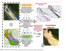
The ADRIPLAN project (10 December 2013 until 10 June 2015) was funded by the European Commission and worked towards an ADRiatic-Ionian maritime spatial PLANning (ADRIPLAN). The project focused on improving the ongoing process to develop Maritime Spatial Planning (MSP) in the region to overcome barriers of full participation of all neighbouring countries in the process.
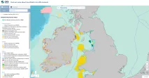
SIMCelt was a two-year cross-border project involving partners from the UK, Ireland and France. It's objectives were to support co-operation between EU Member States on the implementation of the Maritime Spatial Planning (MSP) Directive in the Celtic Seas.
The European Commission (EC) supports policy development and implementation within the EU, working to support the EU’s framework for marine environmental protection. The Commission is also responsible for ensuring that member States apply EU environmental law correctly, helping them to comply with agreed legislation, as well as following up on complaints from citizens and non-governmental organisations.
Marine Scotland Science (MSS) is the scientific division of the Marine Scotland Directorate, the branch of the devolved Scottish Government responsible for the marine and coastal environment. The purpose of MSS is to provide expert scientific, economic and technical advice and services on issues relating the to the marine environment, to provide evidence to support policies and regulatory activities of the Scottish Government, to perform regulatory and enforcement acti
The Marine Strategy Framework Directive (MSFD, 2008/56/EC) requires European threshold values (TVs) for all descriptors to be defined. In particular, for marine litter (descriptor 10), the MSFD Technical Group on Marine Litter (TG ML) decided that coastline macro litter, commonly referred as beach litter, would be the first marine litter issue to be faced.
The conservation or the achievement of the Good Environmental Status (GES) is a priority for any environmental policy mechanism of both EU and non-EU countries. Coherent data management and quality control are fundamental whenever data from different sources are required as in the case of the assessment of environmental status at regional or sub-regional scale sensu Marine Strategy Framework Directive (MSFD).
EMODnet Chemistry delivered the first pan-European Marine Litter database. It has been used to compute EU Marine Litter quantitative Baseline, representing a fundamental step of the MSFD Implementation Strategy to provide comparable assessments and to monitor the effectiveness of litter-reduction measures.
The European contribution to the Ocean Biogeographic Information System (OBIS) is significant with EMODnet playing a pivotal role: around 20 million of these records are provided by EMODnet Biology.
Undertaking a regional cumulative impact assessment requires a vast amount of spatial data. EUSeaMap v2016 was a key data source for defining ecosystem components in reporting on the 2011-2016 HELCOM ‘State of the Baltic Sea’.