The ADRIPLAN project (10 December 2013 until 10 June 2015) was funded by the European Commission and worked towards an ADRiatic-Ionian maritime spatial PLANning (ADRIPLAN). The project focused on improving the ongoing process to develop Maritime Spatial Planning (MSP) in the region to overcome barriers of full participation of all neighbouring countries in the process. While promoting scientifically based political decisions with the aim of promoting a coherent transnational approach to the spatial planning of the marine environment. The wider study area contained the Adriatic-Ionian Macroregion.
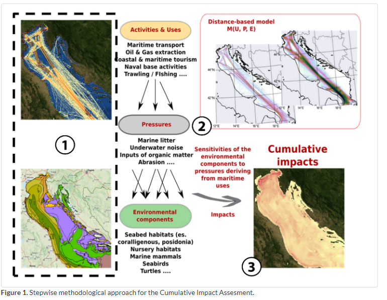
During the project, the users were aiming to create a Cumulative Impact (CI) assessment tool for use in supporting MSP under an Ecosystem-Based Approach (EBA), by assessing the potential cumulative impacts of maritime activities on the marine environment. Data on the location and extent of marine benthic habitats was required to feed into the spatial modelling component of this study, with users looking to a range of sources to fulfil this requirement.
EMODnet Seabed Habitats' Data on the location and extent of Posidonia habitat (Essential ocean variables – seagrass extent dataset) were combined with geospatial datasets on human activities, including offshore industries, fisheries, transport and tourism, and environmental components such as seabed habitats, fish nursery areas and marine species sightings. Sensitivity scores were determined by associating a pressure generated by human use and the target environmental component, considering the extent, level and recovery time of the impact. The impacts of pressures were then combined to visualise the cumulative impact of pressures across the study area. EMODnet provided publicly available data on the extent of the vulnerable seagrass habitat across the study area, without which the impacts on this habitat would not have been able to be assessed.
The main outputs of the CI tool were the cumulative impact maps, sea use overlay analysis maps, the generation of statistical outputs on impact scores for single sea uses and environmental components, and the analysis of gaps in terms of data availability and input data based on data availability maps and statistical outputs. This information supported the MSP implementation process in the study area, ensuring sustainable development of the marine environment whilst conserving potentially impacted habitats. The tool was tested for the Adriatic-Ionian sub-basin, but can be deployed to any research area around the globe.