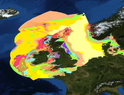
EMODnet Geology - Sea-floor (bedrock)
EMODnet Geology has succeeded providing harmonised, high quality geological information for Europe’s seas. It brings together data from national geological surveys and research organisations to deliver consistent, multi scale information on seabed geology, sediment distribution, coastal behaviour, geological events, mineral resources, and submerged landscapes.
By integrating diverse and often fragmented datasets into standardised products, EMODnet Geology improves access to marine geological knowledge and supports a wide range of users, including policymakers, researchers, industry, and the wider public. The service contributes to a better understanding of the structure, processes, and resources of the seafloor, supporting evidence based decision making and sustainable management of marine environments.
EMODnet Geology aims at providing harmonised information on marine geology in Europe for the entire European seas.
Objectives
The service provides open access to harmonised geological data products and metadata from a distributed network of geoscience organisations across Europe, supporting a better understanding of the seafloor, its processes, and resources. Data and products are delivered in accordance with international standards and made available at multiple scales, ranging from regional overviews to more detailed levels where data coverage allows. The geographical scope covers the European regional seas and extends to the Caribbean Sea, ensuring broad and consistent access to marine geological information for a wide range of users.
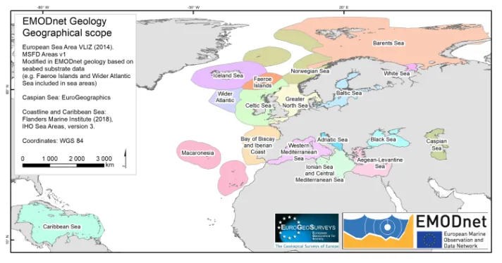
Geology - Sea regions
Data Products
EMODnet Geology provides harmonised map layers and datasets covering seabed substrates, seafloor geology and geological structures, coastal processes, hazards, resources, and palaeoenvironments, supported by Index layers for underlying data. The following data products are already available for Geology:
- Seabed Substrates, Sedimentation rates, Seabed erosion (Index)
- Sea-floor Geology: Pre-Quaternary geology (incl. lithology and stratigraphy), Quaternary geology and geomorphology; General physiographic features
- Coastal Behavior: Satellite and Field data based Coastal migration, Coastal types; Coastal resilience and vulnerability
- Geological Events and Probabilities (e.g. earthquakes, submarine landslides, volcanoes, and Quaternary tectonics, fluid emission, tsunamis, Geological event distribution, landslide susceptibility);
- Marine minerals (e.g. aggregates, hydrocarbons, gas hydrates, marine placers, polymetallic nodules, Marine critical and non critical minerals);
- Submerged landscapes (e.g. Palaeocoastlines, Submerged landforms, springs, Last glacial maximum landscapes, Sea level index points)
- Entity indexes (borehole and grab samples, Seismic and multibeam survey data).
Background
EMODnet Geology has been collecting and harmonising marine geological data from European sea areas since 2009 through successive projects, and is now in its fifth phase. After more than fifteen years, it has established itself as one of the leading providers of publicly available, harmonised in situ seabed data.
Phase I (2009-2012)
During the preparatory phase of EMODnet (Phase I), 14 organisations from 14 countries demonstrated that geological information could be compiled and harmonised at 1:1 million scale to provide map information and supporting data for Northern parts of the regional seas of Europe.
The first phase of the project focused on identifying and assessing the geological information that exist in each country represented in the project and making data freely available at the web portal. All the themes, especially Seabed substrates, Seafloor geology and Coastal behaviour, made significant progress assembling and delivering the data that exists for the European seas.
Phase II (2013-2016)
Phase II started in October 2013. Extended consortium consisted of 36 partners who were able to provide geological information from all the European seas and, by including organisations from Iceland, Norway, and Russia, to expand the information coverage into the North Atlantic Ocean and to the margins of the Arctic (Barents Sea and White Sea). In addition, national and regional networks were established for the better co-ordination of information for example in Iceland, Italy and in the Adriatic and North Sea regions.
The geological data that were compiled in the preparatory project phase I and in the phase II, included Seabed substrate at 1:250 000 scale and at 1:1 000 000 scale where the higher resolution data was not available, Sedimentation rates, Seafloor geology – lithology and stratigraphy, Coastal behaviour, Mineral occurrences (e.g. oil and gas, aggregates, metallic minerals) and Geological events and probabilities (e.g. earthquakes, submarine landslides, volcanic centres). Besides pre-Quaternary seafloor geology, Phase II also included the start of compilations of Quaternary information, and agreement on geomorphological information that should be included in the EMODnet-Geology outputs.
Phase III & III.2 (2017-2019 & 2019-2021)
Phase III of EMODnet Geology project started 12. April 2017 with same consortium as in phase II, added with experts from three universities (Dipartimento Scienze della Terra Università La Sapienza, Roma, Italy; Department of Geology, University of Tartu, Estonia; Foundation for Research and Technology Hellas - Institute of Computer Science, Crete, Greece) in order to fulfil the new task in this phase: Submerged Landscapes. The third phase of the project focused on compiling and delivering map information for each work package but this time in a higher resolution, 1:100,000 or finer where the underlying data permit. The formerly used EUROSION data for coastal behaviour was updated with new field and satellite information, new focus was put on coastal resilience. The EMODnet Geology portal was moved to the EGDI (European Geological Data Infrastructure) portal which considerably improved the quality and performance of the portal service.
Phase III was extended with a new contract into phase III.2 which included the same specifications, except that the geographical coverage of EMODnet Geology was extended into the Caspian Sea. The extension phase started 25. September 2019.
Phase IV (2021-2023)
Phase IV started with a new contract immediately after the Phase III.2 contract ended on 24 September 2021. The specifications of the service contract remained largely similar to those of the previous phase but included new deliverables, notably the seabed erosion rate product and an updated approach to coastal behaviour, expressed through indicators such as migration direction, rate and volume, morphology, and resilience. During this phase, the EMODnet Central portal was also launched, enhancing access to and integration of marine data services. In addition, the geographical scope of EMODnet Geology was extended to include the Caribbean Sea.
Phase IV.2 (2023-2025)
During Phase IV.2, activities continued largely under the same specifications as in the previous phase, ensuring consistency in data production and service delivery. Collaboration with EDITO was initiated during this phase, supporting integration and interoperability efforts. Product development advanced with the refinement of the erosion rate product into an index format, alongside the continued development of additional layers such as coastal vulnerability. Regular updates incorporated new and improved datasets, enhancing overall data quality and coverage. In parallel, cooperation expanded internationally with ASGMI joining the initiative through Caribbean activities, including the establishment of a dedicated working group led by IGME, which has proven to function effectively and foster strong regional collaboration.
Phase V (from 2025 onwards)
In Phase V, activities continue largely under the same specifications as in the previous phases, ensuring consistency in data production and service delivery. However, this phase places increased emphasis on the integration of new datasets, metadata, and thematic products, including organic carbon content of sediments, radiocarbon (C14) measurements of strata, geotechnical properties of the seabed, and information on flora and fauna associated with submerged landscapes. The geographical scope has been adjusted with the exclusion of the Caspian Sea, but cooperation with ASGMI and Caribbean partners continues, further strengthening international collaboration. In addition, new pilot activities and case studies, such as those focusing on lithotectonic units, seabed erosion and method development for quantitative analysis of the distribution of coarse sediments within seabed imagery have been initiated, supporting the development of more advanced and harmonised geological interpretations.
Partnership
The partnership brings together a broad network of partner organisations and subcontractors representing many European countries, with a strong core of national geological surveys from coastal and maritime states. Most of the organisations are also members of the Geological Surveys of Europe (EuroGeoSurveys), providing a stable framework for long-term collaboration and supporting the continuity and visibility of geological survey activities across Europe.
As principal holders of marine geological information, the partnership contributes datasets from across European regional seas and beyond. The project builds mainly on datasets held by the consortium while also connecting to external data providers through interoperable services such as Web Map Services (WMS). This approach enables integration of complementary information sources, for example from organisations compiling seismic or environmental data, without duplicating existing efforts. The use of open standards for data access and delivery supports interoperability and helps ensure long-term sustainability and accessibility of up-to-date marine geological information.
A characteristic of EMODnet Geology is its focus on harmonised, interpreted map products rather than the underlying raw data used to generate them. However, the datasets include information on data origins, enabling users to trace back to the original sources and access more detailed national-scale information where available.This approach strengthens sustainability by maintaining data stewardship at source while enabling consistent access to integrated geological information at the European level.
You can find the full and update list of the consortium on the following section of the website “Partners”.
Communication
In this section you will find thematic-specific communication material, and a direct link to the video gallery.
StoryMap: EMODnet Geology - seafloor mapping
Finding and compiling spatial data of the seafloor is a challenge, because data and information on the seafloor is hardly findable, scattered, rarely compatible and often usable only by insiders. The main reason for this situation is the inaccessibility of the ocean floor and the need to use and rely on mostly geophysical methods. This StoryMap shows the long process of mapping of the seafloor by multibeam echo sounder (MBES), interpretation of the results and the compilation of detail and overview map data (example: seafloor mapping Northeast of Iceland).
StoryMap: EMODnet Geology - Western Baltic Sea Prototype Area
Marine geological data are often collected using different methodologies, classifications, and data models, making it challenging to harmonise and integrate information across national boundaries. Through its Seafloor Geology work package, EMODnet Geology works to harmonise marine geological data and improve their accessibility, interoperability, and usability for a wide range of applications.
This StoryMap presents the Western Baltic Sea prototype area and demonstrates how partners from Germany (BGR), Denmark (GEUS), Poland (PGI-NRI) and Sweden (SGU) collaborated to harmonise geological datasets across borders. Through semantic and geometric harmonisation, national data have been integrated into a coherent transboundary geological dataset of the Quaternary geology, supporting marine research, environmental management, and maritime spatial planning. Explore the StoryMap to discover the harmonisation process and the value of a shared geological knowledge base for the Western Baltic Sea.
StoryMap: Submerged Landscapes. Discover ancient submerged landscapes across Europe
Our coastline is a dynamic zone between land and sea. Beneath the waves lies a submerged landscape that includes palaeocoastlines, drowned forests and evidence of prehistoric settlements from our ancient ancestors. The Submerged Landscapes data layers from EMODnet Geology compile datasets across Europe. With this StoryMap we show a selection of key sites, now preserved at the bottom of the sea, that reveal how these landscapes responded to sea-level change since the last ice-age. Results provide clues to understanding human migration and environmental change. As marine development and natural erosion threaten these fragile baseline records, EMODnet data and data products offer a resource for researchers and developers. Dive into the StoryMap to explore some of these sites and imagine the stories they have to tell.