European Marine Observation and Data Network (EMODnet)
Use Cases
Submit your Use Case
To understand the full benefits of EMODnet, users are kindly asked to describe how EMODnet supports them in their daily work and activities.
If you have developed an application using EMODnet products that you would like to share with us or if you use EMODnet data for other purposes, submit your use case by contacting helpdesk@emodnet.ec.europa.eu.
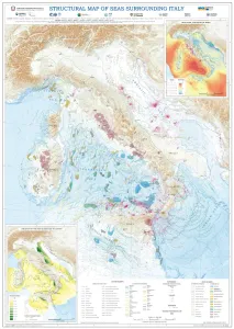
Using EMODnet Geology data, the Department for the Geological Survey of Italy (ISPRA) characterised the structural settings of the seas surrounding Italy. The EMODnet data, particularly from the "Geological events and probabilities" work package, provided insights into tectonic activity, including earthquakes, volcanoes, and submarine landslides. The EMODnet Bathymetry Digital Terrain Model (DTM) helped outline submarine volcanoes, while seabed rock data from the "Seafloor geology" work package aided in understanding geological strata. This comprehensive information allows for the identification of various marine geological settings, forming a solid basis for future studies on marine geohazard assessment, land management, and applied geology.
This study focused on developing an effective route planning methodology for unmanned sea vehicles (USVs), particularly Remotely Operated Vehicles (ROVs) combining EMODnet data and third-party systems.
The Maritime Spatial Planning (MSP) Challenge is an open-source platoform developed by Breda University of Applied Sciences. It hels users manage the blue economy and marine enviornmeny by simulating the impact of decisions on energy, shipping, and marine life. The simulations encourage users to utilize the best available data for assessing the current status and planning the future development of sea space. The data includes EMODnet services, which were used in an MSP Challenge to map bathymetry, biology, human activity and seabed habitat data for a simulation game supporting educational and stakeholder engagement.
The Portuguese Institute for Sea and Atmosphere (IPMA), one of the EMODnet partners, is a state laboratory whose mission is to promote and coordinate scientific research, technological development, innovation and services on sea and atmosphere. IPMA is responsible for executing the geophysical, geological, geotechnical and environmental studies in the REPowereu project, which has the aim of developing up to 10 GW of electrical production centers in the offshore of Portugal, based on oceanic renewable energy until 2030.
The University of Southampton and its Southampton Marine and Maritime Institute is a major European centre for oceanography and marine geoscience. The Southampton Marine and Maritime Institute (SMMI) is the largest entity of its kind in the world, with expertise in everything from naval architecture to social sciences and work to address issues in the natural ocean environment (marine) and human use of the sea (maritime).
MPA Europe project (https://mpa-europe.eu/). The MPA Europe project is using a holistic range of measures of biodiversity from species to ecosystems, including habitats, to map the optimal areas for Marine Protected Areas implementation in Europe. Areas will be prioritised using systematic conservation planning software, which enables alternative weighting of variables and multiple scenarios and thus support wider marine spatial planning. OBIS (https://obis.org/) is responsible for WP3, which will generate species distribution models for at least half of all marine species in Europe to be utilized in the prioritization process.
The Flanders Marine Institute (VLIZ) is an autonomous Belgian non-profit organization which conducts interdisciplinary research on the ocean, seas, coast and estuaries. Its mission is to strengthen science-based knowledge and share it as widely as possible. VLIZ uses new technologies, such as robotics, and focuses on innovation and valorisation. Research areas include the ocean and seas, coasts and tidal systems as well as areas where Flemish marine scientists are or were active.
The Horizon Europe MSP4Bio project used EMODnet multidisciplinary marine in situ data, including from Bathymetry, Biology and many other thematic data, to inform an Ecological-Socio-Economic (ESE) management framework used for science-based MSP to safeguard and restore biodiversity in a coherent European MPA network.
University of Girona used EMODnet datasets in the Horizon EU project Blue-Paths, to develop a dashboard demonstrator with the goal to inform the wider audience about the geographic and social, ecological and economic characteristics of the high-potential areas for offshore wind energy in the Spanish sea space in a dynamic manner.
The University of Aegean is a partner in the MUSICA (Multiple Use of Space for Island Clean Autonomy) project, that developed a smart multi-usage of space (MUS) platform for the concurrent use of three types of renewable energy – wind, photovoltaic and wave – at small islands. The MUS also contributed to the advancement of a successfully tested multi-use platform (MUP), which was previously developed by the University of Aegean and the private company EcoWindWater. In the process of finding optimal siting areas for the MUP, MUSICA used EMODnet map services and data to highlight areas of potential constraints.
, including overlaid datasets for submarine cable routes, offshore wind farm locations, and coastline data. © Osman Onur AKIRMAK. All rights reserved.")


")
